Difference between revisions of "Carmel River Watershed: Map of Soil Type"
From CCoWS Wiki
(→Processing Steps) |
(→Links) |
||
| Line 55: | Line 55: | ||
* [[Maps of the Carmel River Watershed]] | * [[Maps of the Carmel River Watershed]] | ||
| + | * [[Useful Data Sources]] | ||
Latest revision as of 11:34, 6 February 2011

Contents
Metadata
- Original source of data: SSURGO - http://soils.usda.gov/survey/geography/ssurgo/]
- Map produced by: Pam Krone-Davis
- Projected Coordinate System: NAD_1983_UTM_Zone_10N
- Projection: Transverse_Mercator
- Geographic Coordinate System: GCS_North_American_1983
- Datum: D_North_American_1983
- Prime Meridian: Greenwich
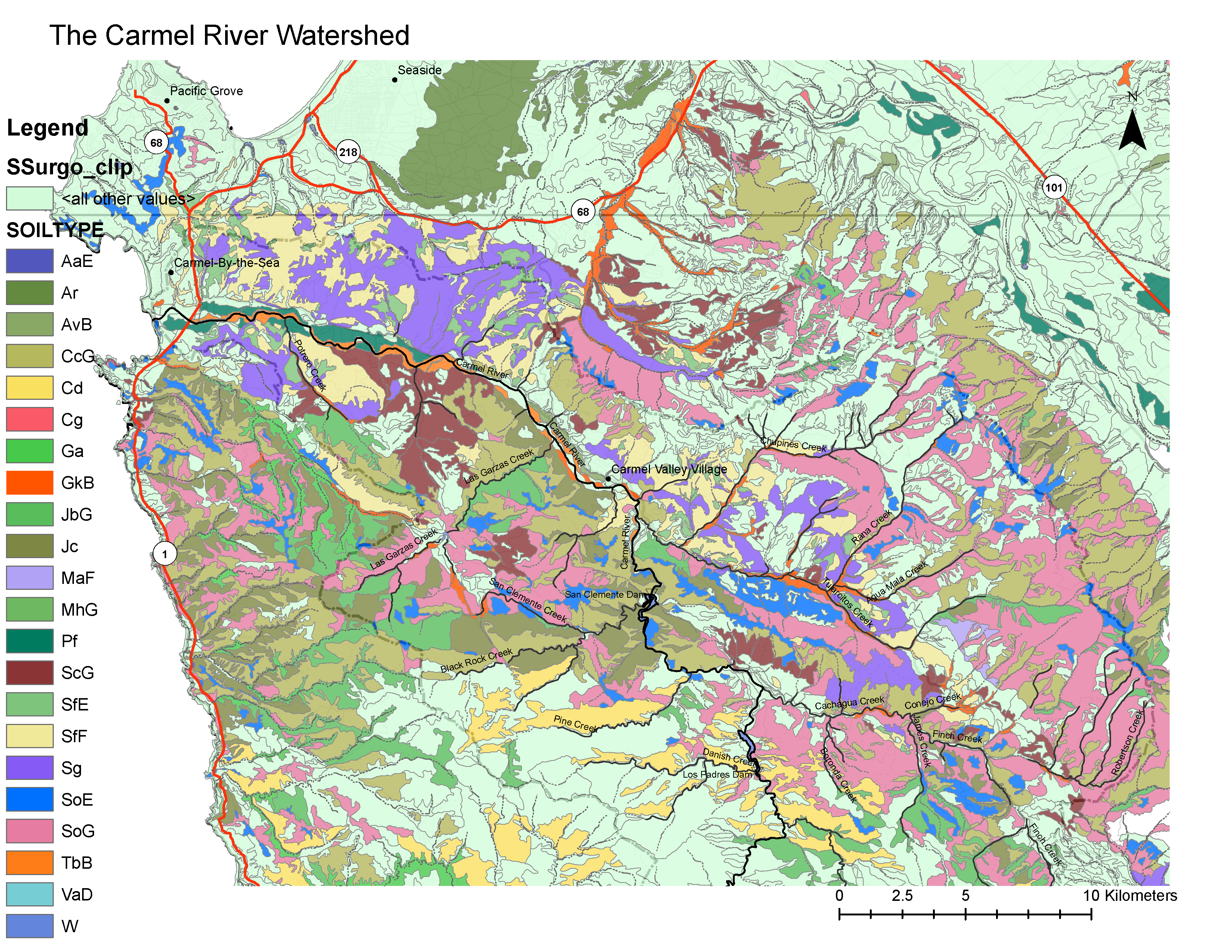
Most Prevalent Soils Adjacent to Streams
From: http://soildatamart.nrcs.usda.gov/manuscripts/CA053/0/monterey.pdf
- AaE: Alo, silty clay, 15 to 30% slopes
- Ar: Arnold/ Santa Ynez, variable soil
- AvB: Arroyo Seco, Gravelly Loam
- CcG Cieneba, Gravelly Sandy Loam on 30-75% slopes
- Cd: Cieneba/ Rock Outcorp, Variable
- Cg: Clear Lake, Clay
- Ga: Gambo/ Sur/ Junipero, Variable
- GkB: Gorgonio Sandy Loam, 0 to 5 % slopes
- JbG: Junipero sandy loam, 30 to 75% slopes
- Jc: Junipero Sur complex
- MaF: McCoy clay loam, 15 t0 30% slope
- MhG: Millsholm loam, 30-50% slopes
- Pf: Pico fine sandy loam
- ScG: San Andreas fine sandy loam, 50 to 75% slopes
- SfE: Santa Lucia shaly clay loam, 2 to 15% slopes
- SfF: Santa Lucia shaly clay loam, 30-50% slopes
- Sg: Santa Lucia-Reliz association
- SoE: Sheridan course sandy loam, 15-30% slopes
- SoG: Sheridan course sandy loam, 30 – 75% slopes
- TbB: Tujunga fine sand 0-5% slope
- VaD: Vista course sandy loam, 5-15% slopes
- W: not defined
Processing Steps
- Added Soil Layer to Carmel River Watershed map from SURGO file.
- Added the acreage for each soil type and displayed only the prevalent ones to reduce number of soil types from 160 to about 20.
- Reviewed which soils displayed and modified the list in order to insure those soils nearest the rivers and streams were shown.
- Created the legend for the soils layer.
- Modified the colors to better distinguish between soil types.