Difference between revisions of "File:Elkhorn Slough Watersheds.jpg"
From CCoWS Wiki
(Map of watersheds surrounding the Elkhorn Slough estuary (map adapted from CSUMB 2007). The white dot on the map indicates the area where Salinas River waters intermittently enter the Old Salinas River Channel and Elkhorn Slough. Copied from: [http://www) |
(No difference)
|
Latest revision as of 08:48, 7 February 2011
Map of watersheds surrounding the Elkhorn Slough estuary (map adapted from CSUMB 2007). The white dot on the map indicates the area where Salinas River waters intermittently enter the Old Salinas River Channel and Elkhorn Slough. Copied from: Elkhorn Slough Foundation
File history
Click on a date/time to view the file as it appeared at that time.
| Date/Time | Thumbnail | Dimensions | User | Comment | |
|---|---|---|---|---|---|
| current | 08:48, 7 February 2011 | 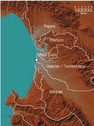 | 316 × 422 (91 KB) | Rogera (Talk | contribs) | Map of watersheds surrounding the Elkhorn Slough estuary (map adapted from CSUMB 2007). The white dot on the map indicates the area where Salinas River waters intermittently enter the Old Salinas River Channel and Elkhorn Slough. Copied from: [http://www |
- You cannot overwrite this file.
File usage
There are no pages that link to this file.