Difference between revisions of "California Central Coast Gage Locations"
From CCoWS Wiki
| Line 84: | Line 84: | ||
* [http://ccows.csumb.edu/home/weather.htm CCoWS list of local links for weather, rivers, lagoons etc.] | * [http://ccows.csumb.edu/home/weather.htm CCoWS list of local links for weather, rivers, lagoons etc.] | ||
* [http://waterdata.usgs.gov/ca/nwis/current?huc_cd=18060004&huc_cd=18060005&huc_cd=18060006&huc_cd=18060011&huc_cd=18060012&index_pmcode_STATION_NM=1&index_pmcode_DATETIME=2&index_pmcode_00065=3&index_pmcode_00060=4&index_pmcode_MEAN=&index_pmcode_MEDIAN=&index_pmc USGS list of local stream gages] | * [http://waterdata.usgs.gov/ca/nwis/current?huc_cd=18060004&huc_cd=18060005&huc_cd=18060006&huc_cd=18060011&huc_cd=18060012&index_pmcode_STATION_NM=1&index_pmcode_DATETIME=2&index_pmcode_00065=3&index_pmcode_00060=4&index_pmcode_MEAN=&index_pmcode_MEDIAN=&index_pmc USGS list of local stream gages] | ||
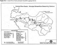
| − | * This MPWMD map has gages named and marked: [[Image:Carmel MPWMD Gages Map FromUnknownReport.jpg| | + | * This MPWMD map has gages named and marked: [[Image:Carmel MPWMD Gages Map FromUnknownReport.jpg|200px]] |
* This CCoWS map has gages marked on it: [http://ccows.csumb.edu/pubs/maps/crwa/Poster/Carmel_Map1-2_36x44.pdf http://ccows.csumb.edu/pubs/maps/crwa/Poster/Carmel_Map1-2_36x44.pdf] | * This CCoWS map has gages marked on it: [http://ccows.csumb.edu/pubs/maps/crwa/Poster/Carmel_Map1-2_36x44.pdf http://ccows.csumb.edu/pubs/maps/crwa/Poster/Carmel_Map1-2_36x44.pdf] | ||
* [http://www.mediawiki.org/wiki/Help:Tables How to edit tables in MediaWiki] | * [http://www.mediawiki.org/wiki/Help:Tables How to edit tables in MediaWiki] | ||
Revision as of 12:36, 22 February 2009
| Watershed | Name | Agency | Easting | Northing | ID Number |
| Carmel | Carmel River below Los Padres | MPWMD | ... | ... | ... |
| Carmel | Carmel River at Sleepy Hollow Weir | MPWMD | ... | ... | ... |
| Carmel | Carmel River at Robles del Rio | USGS | 613917 | 4037311 | 11143200 |
| Carmel | Carmel River at Don Juan Bridge (Garland Park) | MPWMD | ... | ... | ... |
| Carmel | Carmel River near Carmel | USGS | 601108 | 4044069 | 11143250 |
| Carmel | Carmel River at Highway 1 Bridge | MPWMD | ... | ... | ... |
| Carmel | Carmel Lagoon (scroll down) | ... | ... | ... | |
| ... | ... | ... | ... | ... | |
| Gabilan | USGS Gabilan Creek near Salinas | ... | ... | ... | |
| Gabilan | USGS Reclamation Ditch near Salinas | ... | ... | ... | |
| ... | ... | ... | ... | ... |
Links
- CCoWS list of local links for weather, rivers, lagoons etc.
- USGS list of local stream gages
- This MPWMD map has gages named and marked:
- This CCoWS map has gages marked on it: http://ccows.csumb.edu/pubs/maps/crwa/Poster/Carmel_Map1-2_36x44.pdf
- How to edit tables in MediaWiki
- Carmel Watershed
- Clickable map of USGS Surface Water Gages: http://waterdata.usgs.gov/nwis/rt
- Coordinates on USGS web sites are probably not as accurate as coordinates you can get from Google Earth.
- To get coordinates from Google Earth, find the gage, and create a Placemark. The coordinates will be displayed. To get them in a different projection, go to Tools --> Options
- Gages in Monterey are consolidated on this website: http://waterdata.usgs.gov/ca/nwis/current?huc_cd=18060004&huc_cd=18060005&huc_cd=18060006&huc_cd=18060011&huc_cd=18060012&index_pmcode_STATION_NM=1&index_pmcode_DATETIME=2&index_pmcode_00065=3&index_pmcode_00060=4&index_pmcode_MEAN=&index_pmcode_MEDIAN=&index_pmc [1]
