Difference between revisions of "Arundo donax in California's Central Coast Region"
(→Arundo donax in the Central Coast) |
|||
| Line 8: | Line 8: | ||
==''Arundo donax'' in the Central Coast== | ==''Arundo donax'' in the Central Coast== | ||
| − | [[File:arundo-infestation-within-the-salinas-river-watershed.jpg|250px|thumb|Figure 2: Encroachment of ''Arundo donax'' along Salinas River. Map by DENDRA Inc. <ref name="rcdmc"[https://www.rcdmonterey.org/salinas-river-arundo-and-tamarisk-control / RCDMC (Resource Conservation District of Monterey County. Salinas River Arundo and Tamarisk Control. Salinas River Watershed Arundo Control Program.] </ref>.] | + | [[File:arundo-infestation-within-the-salinas-river-watershed.jpg|250px|thumb|Figure 2: Encroachment of ''Arundo donax'' along Salinas River. Map by DENDRA Inc. <ref name="rcdmc">[https://www.rcdmonterey.org/salinas-river-arundo-and-tamarisk-control / RCDMC (Resource Conservation District of Monterey County. Salinas River Arundo and Tamarisk Control. Salinas River Watershed Arundo Control Program.] </ref>.] |
river water used by arundo | river water used by arundo | ||
flood probability | flood probability | ||
Revision as of 20:16, 3 April 2018

An environmental summary created by the ENVS 560/L Watershed Systems class at CSUMB.
Contents
Arundo donax: Invasive Plant
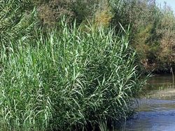
Giant reed (Arundo donax) is a perrenial invasive grass native to Eastern Asia. It is a persistent rhizomatous grass with high biomass production that was introduced to other continents by humans, for building material since many years [2]. This grass can reach up to 20 feet tall in height when healthy, with long, flat, and green leaves [3]. It is considered an ecological threat since it spreads when its rhizomes come in contact with soil within wetlands. This grass spreads along riparian zones and lake shores, and competes with native vegetation for sunlight, water, and nutrients.
flood history
Arundo donax in the Central Coast
[[File:arundo-infestation-within-the-salinas-river-watershed.jpg|250px|thumb|Figure 2: Encroachment of Arundo donax along Salinas River. Map by DENDRA Inc. [4].] river water used by arundo flood probability flood history
Resource Conservation Districts: RCD Monterey County
RCDMC :Special District rcdmc and mcrwa working on arundo
RCDMC Arundo Control Program
why it started two step process of pesticide and burning before and after google earth images
References
- ↑ / CALIPC (California Invasive Plant Council). Arundo donax. Cal-IPC.
- ↑ / Pilu R, Bucci F, Badone FC, Landoni M. 2012. Giant reed (Arundo donax L.): A weed plant or a promising energy crop? African Journal of Biotechnology 11(38) 9163-9174.
- ↑ / Swearingen J, Bargeron C. 2016. Invasive Plant Atlas of the United States. University of Georgia Center for Invasive Species and Ecosystem Health.
- ↑ / RCDMC (Resource Conservation District of Monterey County. Salinas River Arundo and Tamarisk Control. Salinas River Watershed Arundo Control Program.
Disclaimer
This page may contain student work completed as part of assigned coursework. It may not be accurate. It does not necessary reflect the opinion or policy of CSUMB, its staff, or students.