Difference between revisions of "California Central Coast Gage Locations"
From CCoWS Wiki
| Line 8: | Line 8: | ||
| '''Northing''' | | '''Northing''' | ||
| '''ID Number''' | | '''ID Number''' | ||
| + | | '''Close to''' | ||
|- | |- | ||
| Carmel | | Carmel | ||
| [http://www.mpwmd.dst.ca.us/wrd/riverflows/2009/wy2009_bl.htm Carmel River below Los Padres] | | [http://www.mpwmd.dst.ca.us/wrd/riverflows/2009/wy2009_bl.htm Carmel River below Los Padres] | ||
| [[MPWMD]] | | [[MPWMD]] | ||
| + | | ... | ||
| ... | | ... | ||
| ... | | ... | ||
| Line 29: | Line 31: | ||
| 4037311 | | 4037311 | ||
| 11143200 | | 11143200 | ||
| + | | ... | ||
|- | |- | ||
| Carmel | | Carmel | ||
| [http://www.mpwmd.dst.ca.us/wrd/riverflows/2009/wy2009_dj.htm Carmel River at Don Juan Bridge (Garland Park)] | | [http://www.mpwmd.dst.ca.us/wrd/riverflows/2009/wy2009_dj.htm Carmel River at Don Juan Bridge (Garland Park)] | ||
| [[MPWMD]] | | [[MPWMD]] | ||
| + | | ... | ||
| ... | | ... | ||
| ... | | ... | ||
| Line 43: | Line 47: | ||
| 4044069 | | 4044069 | ||
| 11143250 | | 11143250 | ||
| + | | Via Mallorca Rd | ||
|- | |- | ||
| Carmel | | Carmel | ||
| [http://www.mpwmd.dst.ca.us/wrd/riverflows/2009/wy2009_h1.htm Carmel River at Highway 1 Bridge] | | [http://www.mpwmd.dst.ca.us/wrd/riverflows/2009/wy2009_h1.htm Carmel River at Highway 1 Bridge] | ||
| [[MPWMD]] | | [[MPWMD]] | ||
| + | | ... | ||
| ... | | ... | ||
| ... | | ... | ||
| Line 53: | Line 59: | ||
| Carmel | | Carmel | ||
| [http://www.wrh.noaa.gov/cnrfc/versprod.php?sid=RSA&node=KRSA&versnum=0 Carmel Lagoon] (scroll down) | | [http://www.wrh.noaa.gov/cnrfc/versprod.php?sid=RSA&node=KRSA&versnum=0 Carmel Lagoon] (scroll down) | ||
| + | | ... | ||
| ... | | ... | ||
| ... | | ... | ||
| ... | | ... | ||
|- | |- | ||
| + | | ... | ||
| ... | | ... | ||
| ... | | ... | ||
| Line 65: | Line 73: | ||
| Gabilan | | Gabilan | ||
| [http://waterdata.usgs.gov/nwis/uv?cb_00060=on&cb_00065=on&format=gif_default&period=60&site_no=11152600 USGS Gabilan Creek near Salinas] | | [http://waterdata.usgs.gov/nwis/uv?cb_00060=on&cb_00065=on&format=gif_default&period=60&site_no=11152600 USGS Gabilan Creek near Salinas] | ||
| + | | ... | ||
| ... | | ... | ||
| ... | | ... | ||
| Line 71: | Line 80: | ||
| Gabilan | | Gabilan | ||
| [http://waterdata.usgs.gov/nwis/uv?cb_00060=on&cb_00065=on&format=gif_default&period=60&site_no=11152650 USGS Reclamation Ditch near Salinas] | | [http://waterdata.usgs.gov/nwis/uv?cb_00060=on&cb_00065=on&format=gif_default&period=60&site_no=11152650 USGS Reclamation Ditch near Salinas] | ||
| + | | ... | ||
| ... | | ... | ||
| ... | | ... | ||
| ... | | ... | ||
|- | |- | ||
| + | | ... | ||
| ... | | ... | ||
| ... | | ... | ||
Revision as of 15:00, 3 March 2009
Flow Gages
| Watershed | Name | Agency | Easting | Northing | ID Number | Close to |
| Carmel | Carmel River below Los Padres | MPWMD | ... | ... | ... | ... |
| Carmel | Carmel River at Sleepy Hollow Weir | MPWMD | ... | ... | ... | |
| Carmel | Carmel River at Robles del Rio | USGS | 613917 | 4037311 | 11143200 | ... |
| Carmel | Carmel River at Don Juan Bridge (Garland Park) | MPWMD | ... | ... | ... | ... |
| Carmel | Carmel River near Carmel | USGS | 601108 | 4044069 | 11143250 | Via Mallorca Rd |
| Carmel | Carmel River at Highway 1 Bridge | MPWMD | ... | ... | ... | ... |
| Carmel | Carmel Lagoon (scroll down) | ... | ... | ... | ... | |
| ... | ... | ... | ... | ... | ... | |
| Gabilan | USGS Gabilan Creek near Salinas | ... | ... | ... | ... | |
| Gabilan | USGS Reclamation Ditch near Salinas | ... | ... | ... | ... | |
| ... | ... | ... | ... | ... | ... |
Precipitation Gages
| Watershed | Gage name | Hourly?' | Source | Coordinates | ID Number |
| Carmel | Carmel | Yes | CIMIS | ... | 201 |
| Arroyo Seco | Arroyo Seco | Yes | CIMIS | ... | ... |
Gages to insert into above table/s:
- CDEC
- [1]
- Precip hourly:
- CAH Cahoon - dead
- ARY Arroyo Seco
- HTG Hastings
- PPN Point Pinos
- FO1 Fort Ord #1
- FO2 Fort Ord #2
- FTD Fort Ord
- Precip tipping bucket event:
- CHW Chews Ridge
- PNR Ponciano Ridge
- VTC Ventana Cone
- Precip - accumulated - manual entry:
- BGS Big Sur State Park
- River:
- RDR Carmel River at Robles Del Rio
- CML Carmel River near Carmel
- CMR Carmel River at Hwy 1 Bridge
- Stage:
- SLG Salinas River at Lagoon
- Precip hourly:
- [1]
Links
- CCoWS list of local links for weather, rivers, lagoons etc.
- USGS list of local stream gages
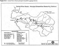
- This MPWMD map has gages named and marked:
- This CCoWS map has gages marked on it: http://ccows.csumb.edu/pubs/maps/crwa/Poster/Carmel_Map1-2_36x44.pdf
- How to edit tables in MediaWiki
- Carmel Watershed
- Clickable map of USGS Surface Water Gages: http://waterdata.usgs.gov/nwis/rt
- Coordinates on USGS web sites are probably not as accurate as coordinates you can get from Google Earth.
- To get coordinates from Google Earth, find the gage, and create a Placemark. The coordinates will be displayed. To get them in a different projection, go to Tools --> Options
- Gages in Monterey are consolidated on this website: http://waterdata.usgs.gov/ca/nwis/current?huc_cd=18060004&huc_cd=18060005&huc_cd=18060006&huc_cd=18060011&huc_cd=18060012&index_pmcode_STATION_NM=1&index_pmcode_DATETIME=2&index_pmcode_00065=3&index_pmcode_00060=4&index_pmcode_MEAN=&index_pmcode_MEDIAN=&index_pmc [2]
