Difference between revisions of "Carmel River Watershed: Map of Elevation"
From CCoWS Wiki
| Line 10: | Line 10: | ||
* Coordinate system: UTM Zone 10 | * Coordinate system: UTM Zone 10 | ||
* Datum: NAD 83 | * Datum: NAD 83 | ||
| + | |||
| + | == Links == | ||
| + | |||
| + | * Maps of the Carmel River Watershed | ||
Revision as of 23:52, 5 February 2009

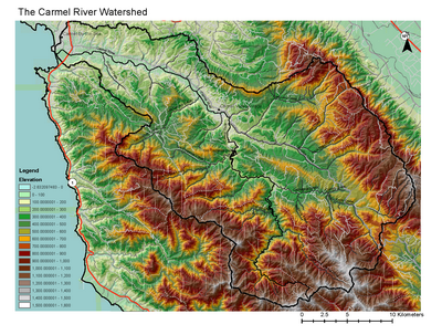
Metadata
- Original source of data: USGS
- Data anlysis: USGS data collated and processed by Wendi Newman and Fred Watson at CSUMB
- Map produced by: Fred Watson
- Coordinate system: UTM Zone 10
- Datum: NAD 83
Links
- Maps of the Carmel River Watershed