Carmel River Watershed: Potero, Pine and Garzas Creeks Flow Duration Analysis
Hydrologic Setting
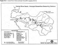
The Carmel River begins in the Santa Lucia Mountains, flowing northwest through the Carmel Valley and drains into the Carmel Lagoon and eventually the ocean at Carmel State Beach. There are two dams in the watershed. The first dam is the San Clemente dam, built in 1921 for the storage of drinking water and flood control. Los Padres dame was built in 1949 to try and slow the loss of capacity in San Clemente dam due to sedimentation. As the Carmel River runs through the Carmel Valley it supplies water to the Carmel Aquifer. This aquifer is the major source of water for the towns of Carmel-by-the-sea, Pebble Beach, Pacific Grove, Monterey and parts of Seaside. The Carmel River and Carmel Lagoon are some of the best remaining steelhead habitat on the central California Coast. Attempting to manage the watershed as a source of municipal water and steelhead habitat has caused it to be one of the most monitored watersheds in central California. There is an extensive network of flow gauges between the US Geological Survey and Monterey Peninsula Water Management District.
Analysis
Summary
Reference
- CSUMB-CCoWS Carmel Watershed Assessment
Links
- The Carmel River Watershed: http://ccows.csumb.edu/pubs/maps/crwa/Poster/Carmel_Map1-2_36x44.pdf
- The network of USGS and MPWMD gauges:
