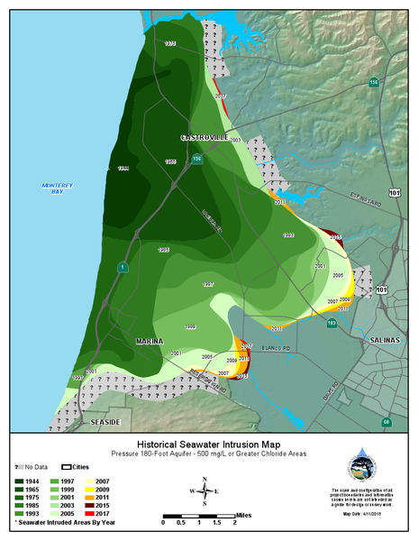
File:2018HistoricSeawaterInstrusionMap180ftAquifer.pdf
From CCoWS Wiki

Size of this preview: 463 × 599 pixels. Other resolution: 464 × 600 pixels.
Original file (816 × 1,056 pixels, file size: 503 KB, MIME type: image/png)
File history
Click on a date/time to view the file as it appeared at that time.
| Date/Time | Thumbnail | Dimensions | User | Comment | |
|---|---|---|---|---|---|
| current | 13:15, 29 March 2019 |  | 816 × 1,056 (503 KB) | StefanieK (Talk | contribs) | Reverted to version as of 20:14, 29 March 2019 |
| 13:15, 29 March 2019 |  | 816 × 1,056 (503 KB) | StefanieK (Talk | contribs) | Reverted to version as of 20:14, 29 March 2019 | |
| 13:15, 29 March 2019 |  | 816 × 1,056 (503 KB) | StefanieK (Talk | contribs) | ||
| 13:14, 29 March 2019 |  | 816 × 1,056 (503 KB) | StefanieK (Talk | contribs) | ||
| 13:06, 29 March 2019 | No thumbnail | (600 KB) | StefanieK (Talk | contribs) |
- You cannot overwrite this file.
File usage
The following page links to this file: