Fort Ord Regional Trail and Greenway (FORTAG)
Contents
Summary
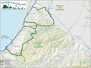
The Fort Ord Rec Trail and Greenway (FORTAG) is a proposed 30-mile network of paved trails and greenways aimed at connecting communities to open space. [1]The proposed route connects the existing Coastal Rec Trail to the communities of Marina, Seaside and Monterey, creating a streamlined, accessible trail network connecting existing public lands and parks, residential communities, California State University Monterey Bay (CSUMB), Fort Ord National Monument and existing transportation corridors. The total cost of te project is estimated at $40 million. In November 2016, Monterey County voters approved $20 million in funding for FORTAG are a part of the transportation bill Measure X. FORTAG construction is pending incorporation of FORTAG into various jurisdictional planning documents, prioritization of Measure X projects and grant funding [2]
Route
FORTAG is composed of two main loops:
- Northern
History
Timeline
Measure X funding
The
Key stakeholders
Maps
Current progress
Links
References
- ↑ http://www.fortag.org/vision.htm
- ↑ "Measure X paves way for new trail network from Monterey to Marina", Monterey County Weekly http://www.montereycountyweekly.com/news/local_news/measure-x-paves-way-for-new-trail-network-from-monterey/article_ff0d851e-cd35-11e6-bd01-b78888f8ec80.html
Disclaimer
This page may contain student work completed as part of assigned coursework. It may not be accurate. It does not necessarily reflect the opinion or policy of CSUMB, its staff, or students.
