Difference between revisions of "Hollister Hills State Vehicle Recreation Area (SVRA)"
| Line 15: | Line 15: | ||
===Hudner and Renz Acquisitions=== | ===Hudner and Renz Acquisitions=== | ||
| − | From the mid-1980s through the mid-1990s, the SVRA acquired just over 3000 acres of land through the purchasing of two adjacent parcels to the north and northeast of the park. | + | From the mid-1980s through the mid-1990s, the SVRA acquired just over 3000 acres of land through the purchasing of two adjacent parcels to the north and northeast of the park.<ref name = "HHSVRA-HR">LSA Associates, Inc., Dillingham Associates, J.J. Van Houten & Associates, Inc., David Chavez Associates. Hollister Hills State Vehicular Recreation Area Final Environmental Impact Report for the Hudner and Renz acquisitions. February 2001. </ref> |
===Mudstone Ranch=== | ===Mudstone Ranch=== | ||
| Line 67: | Line 67: | ||
====1999 & 2001 Hollister Hills SVRA Hudner and Renz Acquisitions EIR==== | ====1999 & 2001 Hollister Hills SVRA Hudner and Renz Acquisitions EIR==== | ||
| − | Following the creation of the Hollister Hills SVRA in the mid-1970s, [[California Department of Parks and Recreation | State Parks]] determined that acquiring adjacent parcels would be beneficial to the unit. The acquisition required the creation of an EIR, and mitigation/monitoring measures are briefly described below: <ref | + | Following the creation of the Hollister Hills SVRA in the mid-1970s, [[California Department of Parks and Recreation | State Parks]] determined that acquiring adjacent parcels would be beneficial to the unit. The acquisition required the creation of an EIR, and mitigation/monitoring measures are briefly described below: <ref name = "HHSVRA-HR"</ref> |
* Geologic hazards: | * Geologic hazards: | ||
** Following seismic activity reconnaissance of all trails will be conducted and any damages to roads or trails will be addressed with a restoration program. | ** Following seismic activity reconnaissance of all trails will be conducted and any damages to roads or trails will be addressed with a restoration program. | ||
Revision as of 12:21, 8 April 2020
An environmental summary by the ENVS 560/L Watershed Systems class at CSUMB.
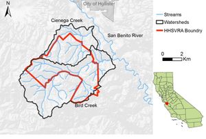
The Hollister Hills State Vehicle Recreation Area (SVRA) is located just south of the City of Hollister in San Benito County, California (Image 1). The park became a designated SVRA as part of the Chappie-Z'Berg Off-Highway Motor Vehicle Law as a state-wide effort to reduce the negative environmental impacts of OHV riding.[1]

Contents
History
The Hollister Hills State Vehicle Recreation Area (SVRA) began as 600 acres of privately owned land purchased by Jesse Whitton after an expedition through the area with John C. Fremont in 1846.[2] In 1959, Jesse Whitton's great grandson, Howard Harris, inherited the land and created a privately operated motorcycle park in the 1950s.[3][4]
Off-highway vehicle (OHV) recreation became increasingly popularized in the 1970s through the onset of dirt bike and motocross racing,[5] and the desire to ride motorcycles off paved roads surged.[5] Unmanaged and unrestricted OHV use began raising environmental concerns, resulting in recognition of the need for designated spaces for regulated OHV recreation.[4][6] In 1975, the Hollister Hills SVRA was acquired by the California Department of Parks and Recreation and became the the first of nine SVRAs in California as part of as a state-wide effort to reduce the negative environmental impacts of OHV riding reduce the negative environmental impacts of OHV riding.[4]
Hudner and Renz Acquisitions
From the mid-1980s through the mid-1990s, the SVRA acquired just over 3000 acres of land through the purchasing of two adjacent parcels to the north and northeast of the park.[7]
Mudstone Ranch
The Mudstone ranch makes up the northern side of the SVRA. In 2016, this area was opened to the public, and is specifically dedicated to hiking, biking, and equestrian use. Additionally, a number of cattle ranchers still use the ranch for grazing purposes. [8] Mudstone Ranch is considered a buffer zone between the motorized trails and nearby housing developments. Maintaining this buffer zone helps to reduce noise from the vehicular use at the SVRA.
Park Amenities
The park encompasses 6,800 acres of land and a total of 152 miles of trails, 128 of which are designated for OHV use only.[4] A map of all trails within the SVRA can be found here. While the park is popular for its OHV trails, it also provides several other amenities and recreational opportunities including:
- Hiking, biking, and equestrian riding trails
- Motocross tracks
- Camping
- Special events including:
- Weddings
- Film shoots
- Four-wheel drive vehicle training for local agencies
Management
Since it's inception, Hollister Hills SVRA has been carefully managed to achieve environmental sustainability while simultaneously balancing the community's desire for vehicular recreation.
Environmental Challenges
OHV use can affect soil, vegetation, wildlife, air and water quality, and overall watershed function. Specific environmental effects include[9][10]:
- Loosening/removal of topsoil and soil compaction
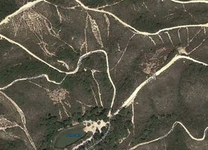
- Gullying/erosion (Image 2)
- Increased severity of landslides
- Reducing vegetation cover through:
- Crushing/breaking
- Diminished plant growth from soil compaction
- Disrupting photosynthesis from dust
- Permitting encroachment of invasive plant species by reducing native plant cover
- Wildlife disturbance through
- Reduced habitat/ habitat fragmentation
- Noise pollution
- Vehicle/animal collisions
- Sedimentation, high turbidity, and pollution in aquatic ecosystems
- Decreased air quality from dust and combustion by-products
Environmental Impact Reports
1977 Environmental Impact Report (EIR) & SVRA Plan
Following the acquisition of Hollister Hills SVRA into the California State Park system in 1975, an EIR was prepared to support the development of the recreation area. This document identified a number of impact mitigation measures that are summarized below: [11]
- Erosion control and management through:
- Addressing problems while they're still minor
- Restricting recreation use that causes severe or uncontrollable erosion
- Using "rotation and rest" techniques allowing for the natural rehabilitation of an erosion event
- Construction of catchment basins and diffusion of water from the basins to reduce downstream erosion
- Revegetation by means of discing, seeding, and the application of hay and fertilizer.
- Reduction of air and noise pollution by discouraging visitors from "revving" their engines.
- Cultural Resource protection through research, surveys, and storage and collection of artifacts prior to development.
- Lowering of aesthetic impacts by designing trails away from highways or other high traffic viewsheds and the use of landscaping to hide objectionable views.
- Mitigation of fire risk by requiring vehicle spark arresters, leveraging prescription burns, and restricting fires/smoking to specific areas
- Wildlife Management through the encouragement of wildlife
1999 & 2001 Hollister Hills SVRA Hudner and Renz Acquisitions EIR
Following the creation of the Hollister Hills SVRA in the mid-1970s, State Parks determined that acquiring adjacent parcels would be beneficial to the unit. The acquisition required the creation of an EIR, and mitigation/monitoring measures are briefly described below: Cite error: Closing </ref> missing for <ref> tag
Cite error: <ref> tags exist, but no <references/> tag was found
