Difference between revisions of "Los Osos Groundwater Basin and Sewer"
(→Sewer) |
(→Los Osos Groundwater Basin) |
||
| Line 11: | Line 11: | ||
== Los Osos Groundwater Basin == | == Los Osos Groundwater Basin == | ||
| − | The Los Osos Groundwater Basin provides residential, commercial and agricultural water for Los Osos. The basin covers about 10 square miles with a maximum depth of approximately 1,000 feet. The basin is underlain by unconsolidated deposits such as alluvium, ancient sand dunes and mostly impermeable Paso Robles Formation and basement Franciscan Complex <ref> Yates and Wiese. 1988. Hydrogeology and water resources of the Los Osos Valley ground-water basin, San Luis Obispo County, California. U.S. Geological Survey. Water-Resources Investigations Report 88-4081. [https://pubs.usgs.gov/wri/1988/4081/report.pdf] </ref>. Water is extracted from the multi-level Paso Robles Formation, underneath which lies the Franciscan Complex. The Franciscan Complex does not bear water and confines the basin to the west <ref> Michael Brandman Associates. 2008. Draft Environmental Impact Report County of San Luis Obispo: Los Osos Wastewater Project. Irvine, California. [http://www.slocounty.ca.gov/Assets/PW/LOWWP/document+library/DEIR.pdf] </ref>. | + | The Los Osos Groundwater Basin provides residential, commercial and agricultural water for Los Osos. The basin covers about 10 square miles with a maximum depth of approximately 1,000 feet. The basin is underlain by unconsolidated deposits such as alluvium, ancient sand dunes and mostly impermeable Paso Robles Formation and basement Franciscan Complex <ref> Yates and Wiese. 1988. Hydrogeology and water resources of the Los Osos Valley ground-water basin, San Luis Obispo County, California. U.S. Geological Survey. Water-Resources Investigations Report 88-4081. [https://pubs.usgs.gov/wri/1988/4081/report.pdf] </ref>. Water is extracted from the multi-level Paso Robles Formation, underneath which lies the Franciscan Complex. The Franciscan Complex does not bear water and confines the basin to the west <ref name="DEIR"> Michael Brandman Associates. 2008. Draft Environmental Impact Report County of San Luis Obispo: Los Osos Wastewater Project. Irvine, California. [http://www.slocounty.ca.gov/Assets/PW/LOWWP/document+library/DEIR.pdf] </ref>. |
Saltwater intrusion was first recorded in the Los Osos Groundwater Basin in 1972 by the Department of Water Resources. Saltwater has subsequently increased on the western edge of the basin where the water table is shallow, impacting water purveyor's access to fresh water. Overdraft of the lower aquifer in response to nitrate pollution of the upper aquifer has increased sea water intrusion <ref name="Basin Plan"> Cleath and Associates. 2005. Draft Final Report: Seawater intrusion assessment and lower aquifer source investigation of the Los Osos Valley Ground Water Basin San Luis Obispo, California. Prepared for: Los Osos Community Services District </ref>. The annual advance of saltwater intrusion from 2005-2015 was approximately 190 feet <ref name ="LO Basin Plan"> Cleath-Harris Geologists. 2016. Los Osos Basin Plan: Groundwater Monitoring Program 2015 Annual Monitoring Report. </ref>. | Saltwater intrusion was first recorded in the Los Osos Groundwater Basin in 1972 by the Department of Water Resources. Saltwater has subsequently increased on the western edge of the basin where the water table is shallow, impacting water purveyor's access to fresh water. Overdraft of the lower aquifer in response to nitrate pollution of the upper aquifer has increased sea water intrusion <ref name="Basin Plan"> Cleath and Associates. 2005. Draft Final Report: Seawater intrusion assessment and lower aquifer source investigation of the Los Osos Valley Ground Water Basin San Luis Obispo, California. Prepared for: Los Osos Community Services District </ref>. The annual advance of saltwater intrusion from 2005-2015 was approximately 190 feet <ref name ="LO Basin Plan"> Cleath-Harris Geologists. 2016. Los Osos Basin Plan: Groundwater Monitoring Program 2015 Annual Monitoring Report. </ref>. | ||
Revision as of 17:34, 5 April 2017
A watershed-related issue examined by the ENVS 560/L Watershed Systems class at CSUMB.
Contents
Summary
Los Osos, on the central coast of CA,
Location
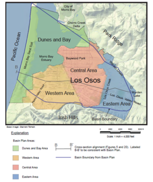
Los Osos is an unincorporated community south of Morro Bay in San Luis Obispo County, CA with a population of 14,276 in 2010 [1]. The town's water supply is locally sourced from the Los Osos Groundwater Basin, which is managed by three water providers: Los Osos Community Services District (LOCSD), Golden State Water Company, and S&T Mutual Water Company [2].
Los Osos Groundwater Basin
The Los Osos Groundwater Basin provides residential, commercial and agricultural water for Los Osos. The basin covers about 10 square miles with a maximum depth of approximately 1,000 feet. The basin is underlain by unconsolidated deposits such as alluvium, ancient sand dunes and mostly impermeable Paso Robles Formation and basement Franciscan Complex [3]. Water is extracted from the multi-level Paso Robles Formation, underneath which lies the Franciscan Complex. The Franciscan Complex does not bear water and confines the basin to the west [4].
Saltwater intrusion was first recorded in the Los Osos Groundwater Basin in 1972 by the Department of Water Resources. Saltwater has subsequently increased on the western edge of the basin where the water table is shallow, impacting water purveyor's access to fresh water. Overdraft of the lower aquifer in response to nitrate pollution of the upper aquifer has increased sea water intrusion [5]. The annual advance of saltwater intrusion from 2005-2015 was approximately 190 feet [6].
Rainfall and runoff percolation accounts for the majority of aquifer recharge. Additional sources of basin recharge are from irrigation and septic system return flow, as the town has strictly used septic systems for wastewater treatment until recently [5].
Sewer
Los Osos residents have used septic systems for wastewater treatment for over 40 years [4].
Cost
Current Status
References
...Proust, M. 1901. Poetica nausea. J. Nauseum. pp 1-9999.
Disclaimer
This page may contain student work completed as part of assigned coursework. It may not be accurate. It does not necessary reflect the opinion or policy of CSUMB, its staff, or students.
Cite error: <ref> tags exist, but no <references/> tag was found
