Difference between revisions of "Maps of the Carmel River Watershed"
From CCoWS Wiki
(→Table of thumbnails) |
(→Table of thumbnails) |
||
| Line 20: | Line 20: | ||
| Land cover [[Media:Carmel_land_use_and_land_cover.pdf|PDF]] | | Land cover [[Media:Carmel_land_use_and_land_cover.pdf|PDF]] | ||
[[Image:Carmel_land_use_and_land_cover.png|100px]] | [[Image:Carmel_land_use_and_land_cover.png|100px]] | ||
| − | | | + | | Land Cover and ownership [[http://ecoviz.csumb.edu/wiki/index.php/Image:Carmel_LandUse_Map.pdf]] |
|- | |- | ||
|} | |} | ||
| Line 45: | Line 45: | ||
## Mean temperature of coldest month | ## Mean temperature of coldest month | ||
## Mean temperature of warmest month | ## Mean temperature of warmest month | ||
| − | # Land ownership | + | # Land ownership |
# Points of interest | # Points of interest | ||
Revision as of 22:32, 5 February 2009
Table of thumbnails
Elevation PDF
|
Slope PDF | Fires of 2008 PDF
|
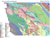
Geology PDF
|
Precipitation PDF
|
Soil type PDF
|
Soil erosion index PDF
|
Land cover PDF
|
Land Cover and ownership [[1]] |


- Terrain
- Elevation
- Slope
- Land use / land cover:
- Geology
- Lithology and Faults
- Carmel River Watershed Geology/Faults Meta Data
- Lithology and Faults
- Soils
- Soil type:
- Carmel_River_Watershed_Soils Meta Data
- Soil erosion index
- Soil type:
- Fires
- 2008 Basin Complex Fire:
- Carmel River Watershed Burn Severity Meta Data
- Historical fires
- 2008 Basin Complex Fire:
- Climate
- Mean annual precipitation:
- Carmel_River_Watershed_Precipitation Meta Data
- Mean temperature of coldest month
- Mean temperature of warmest month
- Mean annual precipitation:
- Land ownership
- Points of interest