Difference between revisions of "Municipal Water Service Boundaries in Southern Monterey Bay Region"
From CCoWS Wiki
(→CalAM Boundaries) |
(→References) |
||
| Line 32: | Line 32: | ||
== References == | == References == | ||
| − | + | <references> | |
== Disclaimer == | == Disclaimer == | ||
This page may contain student work completed as part of assigned coursework. It may not be accurate. It does not necessary reflect the opinion or policy of [[CSUMB]], its staff, or students. | This page may contain student work completed as part of assigned coursework. It may not be accurate. It does not necessary reflect the opinion or policy of [[CSUMB]], its staff, or students. | ||
Revision as of 12:12, 4 April 2016
In Progress. Summary of southern Monterey Bay's municipal water boundaries.
Contents
Summary
...a few sentences...
Location
...Name the smallest watershed (or other applicable region) within which the issue occurs...
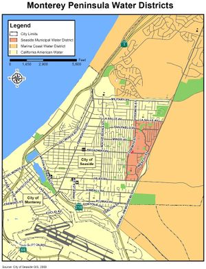
Southern Monterey Bay Municipal Water Agencies
Multiple agencies serve Monterey Bay's water needs including, but not limited to:
- California American Water Company (CalAm)
- Seaside Municipal Water System [1]
- Marina Coast Water District (MCWD)
- Private wells
CalAM Boundaries
In 1966 CalAm purchased the southern Monterey Bay's water infrastructure from the California Water and telephone Company [2].
Seaside Municipal Water System Boundaries
Between CalAm and MCWD boundaries is the Seaside Municipal Water System within the City of Seaside. The Seaside Municipal Water System is small municipal water system composed of one groundwater well and two 500,000 gallon water tanks.
MCWD Boundaries
...
