Pajaro Valley Groundwater Overdraft Concerns
Pajaro Valley Groundwater Overdraft Concerns examined by the ENVS 560/L Watershed Systems class at CSUMB.
Contents
Summary
The Pajaro Valley is an agriculturally import part of the California Central Coast area and provides jobs and homes for many in the area. Over the past several decades, groundwater pumping for agriculture and an increasing population has led to an overdraft of the aquifer that threatens the agricultural and municipal freshwater supplies in the area. Groundwater overdraft occurs when pumping rate exceeds the recharge rate over an extended period of time. As a result of groundwater overdraft, seawater intrusion into the aquifer could impair future freshwater use in the valley. To further complicate the matter, aquifer recharge is a very lengthy process that takes tens or even hundreds of years even after mitigating steps have been taken.s west into Monterey Bay and north to the Soquel-Aptos basin. It is bound to the South by Elkhorn Slough and to the East by the San Andreas fault.[1] [2]
Location
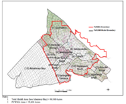
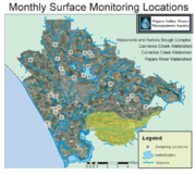
The Pajaro Valley lies in Central California and includes parts of Monterey, Santa Cruz, San Benito, and Santa Clara counties. The Pajoro Valley aquifer extends west into Monterey Bay and north to the Soquel-Aptos basin. It is bound to the South by Elkhorn Slough and to the East by the San Andreas fault. The watershed above this aquifer covers approximately 80,000 acres. [3] The Carneros Creek Watershed is the southern boundary of the Pajaro Valley and designates a groundwater ridge between the Salinas Valley.


Resources at stake
Groundwater overdraft in a coastal region increases the risk of seawater intrusion. As the groundwater level diminishes, saline water will fill the void left by the overdraft, rendering the ground useless for agriculture and contaminating the freshwater aquifer. If the groundwater overdraft in the Pajaro Valley is not mitigated, parts of Monterey, Santa Cruz, Santa Clara, and San Sebastian counties within the Pajaro Valley could experience an agricultural collapse and a freshwater shortage that would require complicated and costly drinking water delivery schemes. The effects of agricultural disruption could have economic ramifications for the Central Coast and the State.
Stakeholders
The Pajaro Valley includes agricultural, developmental, municipal, and conservation activities into a water district that extends into three separate counties. Some of the major stakeholders include:
- The Pajaro Valley Water Management Agency [PVWMA] was established in 1984 in order to manage groundwater issues in the Pajaro Valley in the region.
- The Pajaro River Watershed Flood Prevention Authority was established in 2000 to develop and implement flood prevention strategies for the Pajaro River. Any plans for groundwater recharge will have to be coordinated through the Flood Prevention Authority. [4]
- The counties of Monterey, Santa Clara, Santa Cruz, and San Benito all have some portion of Pajaro Valley within their borders.
- The City of Watsonville is in the center of the Pajaro Valley and will require groundwater resources for future development. [5]
Laws, policies, & regulations
Currently in California landowners possess the ability to pump ground water as long as it is put to beneficial use. Assembly Bill 3030 was passed in 2002 and enables designated local agencies to form groundwater management plans. The PVWMA is the designated agency that voluntarily creates groundwater management plans for the the Pajaro Watershed. If agencies are unable to resolve local groundwater management issues, actions by local governments to enact local ordinances are necessary.[1]
Science
Groundwater is recharged through gravity driven infiltration of surface water. Water seeps between substrate particles downward until hitting the water level or impervious surface. Current studies are examining groundwater recharge times and examining any relationships between groundwater quality and watershed land use.
Tools
The PVWMA has developed groundwater and watershed models for the Pajaro Valley and are currently using those resources to better education stakeholders and decision makers on possible solutions to the groundwater overdraft dilemma. Additional modeling of the Carneros watershed could prove useful in the future if the the Pajaro Valley groundwater overdraft increases and extends into other watersheds.
References
- ↑ 1.0 1.1 California Department of Water Resources. 2010. Groundwater Information Center [30 January 2011]. Available from: http://www.water.ca.gov/groundwater/index.cfm
- ↑ Stephens T. 18 November 2007. UCSC hydrologist provides expert advice on Pajaro Valley's water supply. UCSC News [Internet]. [cited 31 January 2011]. Available from: http://news.ucsc.edu/2007/11/1759.html
- ↑ 3.0 3.1 3.2 [PVWMA] Pajaro Valley Water Management Agency. 2006. Basin management plan documents. [30 January 2011]. Available from: : http://www.pvwma.dst.ca.us/
- ↑ Pajaro River Watershed Flood Prevention Authority
- ↑ City of Watsonville
Links
Disclaimer
This page may contain student work completed as part of assigned coursework. It may not be accurate. It does not necessary reflect the opinion or policy of CSUMB, its staff, or students.