Search results
From CCoWS Wiki
Create the page "Fred" on this wiki!
- == Fred Watson ==1 KB (143 words) - 15:32, 13 January 2009
- This Wiki is administratively maintained by [[Fred Watson]]59 B (8 words) - 11:44, 20 January 2009
- ...e, add "example" of BUs for local waterbody '''Phase 1: Bryan V'''. '''See Fred's notes on 3/27''' Sorted by degree of completion of edits & review, so that Fred can keep track of what he needs to look at next:66 KB (9,345 words) - 15:57, 19 March 2021
- ...u/amws M.S. in Environmental Science program] at [[CSUMB]] is taught by Dr Fred Watson and Dr Doug Smith each spring (2009 - 2021, and counting...). One se ...is web site, please email [http://science.csumb.edu/~fwatson/index.html Dr Fred Watson].753 B (126 words) - 13:02, 27 February 2021
- * Data anlysis: USGS data collated and processed by Wendi Newman and [[Fred Watson]] at CSUMB * Map produced by: Randy Holloway and [[Fred Watson]]816 B (112 words) - 08:32, 6 February 2011
- * Data analysis: Cropped from national scale to just California Coast by [[Fred Watson]], in Arc ASCII GRID format. * Base map compiled by Erin Stanfield, [[Fred Watson]], Wendi Newman.1 KB (199 words) - 08:35, 6 February 2011
- * Data analysis: USGS data collated and processed by Wendi Newman and [[Fred Watson]] at CSUMB440 B (63 words) - 10:43, 6 February 2011
- ...for raster data both in terms of analysis and visualizations (is this true Fred?).8 KB (1,322 words) - 08:48, 20 November 2010
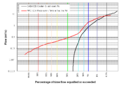
File:GabilanWatershed FlowDurationAnalysis.png * Created in Excel using daily USGS flow data by [[Fred Watson]] as an example to ENVS 560 class.(900 × 639 (41 KB)) - 15:07, 20 February 2009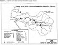
File:Carmel MPWMD Gages Map FromUnknownReport.jpg [[Fred Watson]] obtained this map from Zachary Croyle, who presumably obtained it(1,131 × 890 (118 KB)) - 12:34, 22 February 2009- Research at the site is led by [[Fred Watson|Dr Fred Watson]] from [[CSUMB]]. * [[Fred Watson]] - project leader961 B (140 words) - 18:48, 31 March 2014
- * Rob Vertessy, Fred Watson, Joel Rahman, Susan Cuddy, Francis Chiew, Phil Scanlon, Shane Seaton * Fred Watson, Joel Rahman, Shane Seaton (2001). Deploying environmental software3 KB (457 words) - 13:51, 11 April 2017
- * Data anlysis: USGS data collated and processed by Wendi Newman and [[Fred Watson]] at CSUMB672 B (97 words) - 08:36, 6 February 2011
- * Original source of data: Monterey County - Rosenberg and [[Fred Watson]] at CSUMB. California American Water well data from CalAm Permit #21,007 B (138 words) - 08:55, 6 February 2011
- Fred says: Its unclear what this sentence means: Fred says: To help shorten the page, some of the material in "Watershed Descript3 KB (549 words) - 11:22, 10 April 2012
- * Data analysis: [[Fred Watson]] (watershed boundary); Patty Cubanski (elevation)764 B (93 words) - 15:31, 10 February 2011
- ** Watershed boundary: Watershed analysis in ArcMap by [[Fred Watson]] based on [[National Map]] 1/3 arc-second elevation data * Data analysis: [[Fred Watson]] (watershed boundary)820 B (102 words) - 11:01, 6 February 2011
- ** Watershed boundary: Watershed analysis in ArcMap by [[Fred Watson]] based on [[National Map]] 1/3 arc-second elevation data * Data analysis: [[Fred Watson]] (watershed boundary)977 B (126 words) - 13:21, 9 February 2011
- ** Watershed boundary: Watershed analysis in ArcMap by [[Fred Watson]] based on [[National Map]] 1/3 arc-second elevation data * Data analysis: [[Fred Watson]] (watershed boundary); Ryan Bassett (FEMA floodplain data)1 KB (152 words) - 11:25, 10 February 2011
- ** Watershed boundary: Watershed analysis in ArcMap by [[Fred Watson]] based on [[National Map]] 1/3 arc-second elevation data * Data analysis: [[Fred Watson]] (watershed boundary)1 KB (167 words) - 16:11, 10 February 2011

