Urban stormwater management in Santa Cruz County
A watershed-related issue examined by the ENVS 560/L Watershed Systems class at CSUMB.
Contents
Background
Urban stormwater runoff is caused by rain or snow melt that runs off surfaces such as paved streets, highways, rooftops and parking lots, potentially carrying a variety of pollutants such as oil, sediment, pesticides trash and bacteria. Depending on the system, this runoff can drain directly into a local stream, lake or ocean. Polluted stormwater discharges from Municipal Separate Storm Sewer Systems [1], which is generally not treated before entering a local waterbody [2]. The 1972 Federal Clean Water Act (CWA) regulates urban stormwater runoff and other "non-point source" discharges by the Regional Water Quality Control Boards (RWQB) and National Pollution Discharge Elimination System (NPDES) general permits and stormwater management program requirements.
Two phases of MS4 permits: Phase 1
- Medium (100,000-250,000 people) to large (>250,000 people) municipalities are required to obtain NPDES permit coverage for their stormwater discharges.
- A Storm Water Management Plan/Program (SWMP) is required under this permit with a goal of reducing the discharge of pollutants to the maximum extent practicable (MEP), the performance standard specified by Section 402(p) of the Clean Water Act. [1]
Phase 2
- Small MS4s in urbanized areas and small MS4s outside urbanized areas, that are regulated and designated by the permitting authority, are required to obtain NPDES permit coverage for their stormwater discharges.
Overview of Santa Cruz County
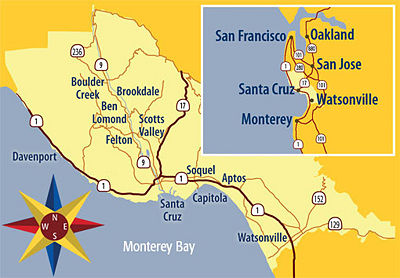
The County of Santa Cruz is located on California's Central Coast just over 70 miles south of San Francisco; 30 miles southwest of San Jose; and 43 miles north of Monterey. It is bordered by the San Mateo County to the north, Santa Clara County to the east, Monterey County to the south, and the Pacific Ocean on the west. The peak of the Santa Cruz Mountain Range is over 2,600 feet. The climate is generally Mediterranean but has low humidity. The mean annual precipitation is 31 inches, occurring predominantly between November and April [3].
Santa Cruz County, a Phase 2 municipality, has four incorporated cities including Scotts Valley, Santa Cruz, Capitola, and Wastonville, with a combined population of nearly 223,000 inhabitants [4]. The incorporated areas of the county, with a combined total population of approximately 136,000, include Aptos, Ben Lomond, Bonny Doon, Boulder Creek, Brookdale, Corralitos, Davenport, Felton, Freedom, La Selva Beach, Rio Del Mar, Soquel and Zayante, also contribute to runoff issues in the region [5].
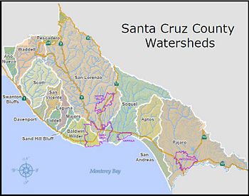
Santa Cruz County residents and municipalities recognize that the natural resources located in the region provide important habitats for aquatic life of all varieties and opportunities for public recreation and enjoyment as well as commercial operations and ventures. It is understood that all urban runoff eventually flows to the Monterey Bay National Marine Sanctuary (MBNMS), a federally protected marine area of biological and economical importance along the Central Coast of California.
Incorporated Cities
- City of Scotts Valley
- Population: 11,764
- Square miles: 4.6
- Population: 11,764
- City of Santa Cruz
- Population: 58,982
- Square miles: 12
- Population: 58,982
- City of Capitola
- Population: 10,073
- Square miles: 1.6
- Population: 10,073
- City of Watsonville
- Population: 51,882
- Square miles: 5.9
- Population: 51,882
References
- ↑ 1.0 1.1 SWRCB Municipal Stormwater Program
- ↑ Stormwater Discharges From Municipal Separate Storm Sewer Systems (MS4s)
- ↑ Climate Data
- ↑ Population Statistics for Incorporated Cities of Santa Cruz County
- ↑ Population Statistics for Incorporated Cities of Santa Cruz County
- ↑ Population Statistics for Incorporated Cities of Santa Cruz County
Links
Disclaimer
This page may contain student work completed as part of assigned coursework. It may not be accurate. It does not necessary reflect the opinion or policy of CSUMB, its staff, or students.

