|
Data Type |
Description |
Browser Quick View |
Google Earth Quick View
(Right click to save and open in Google Earth)
|
|
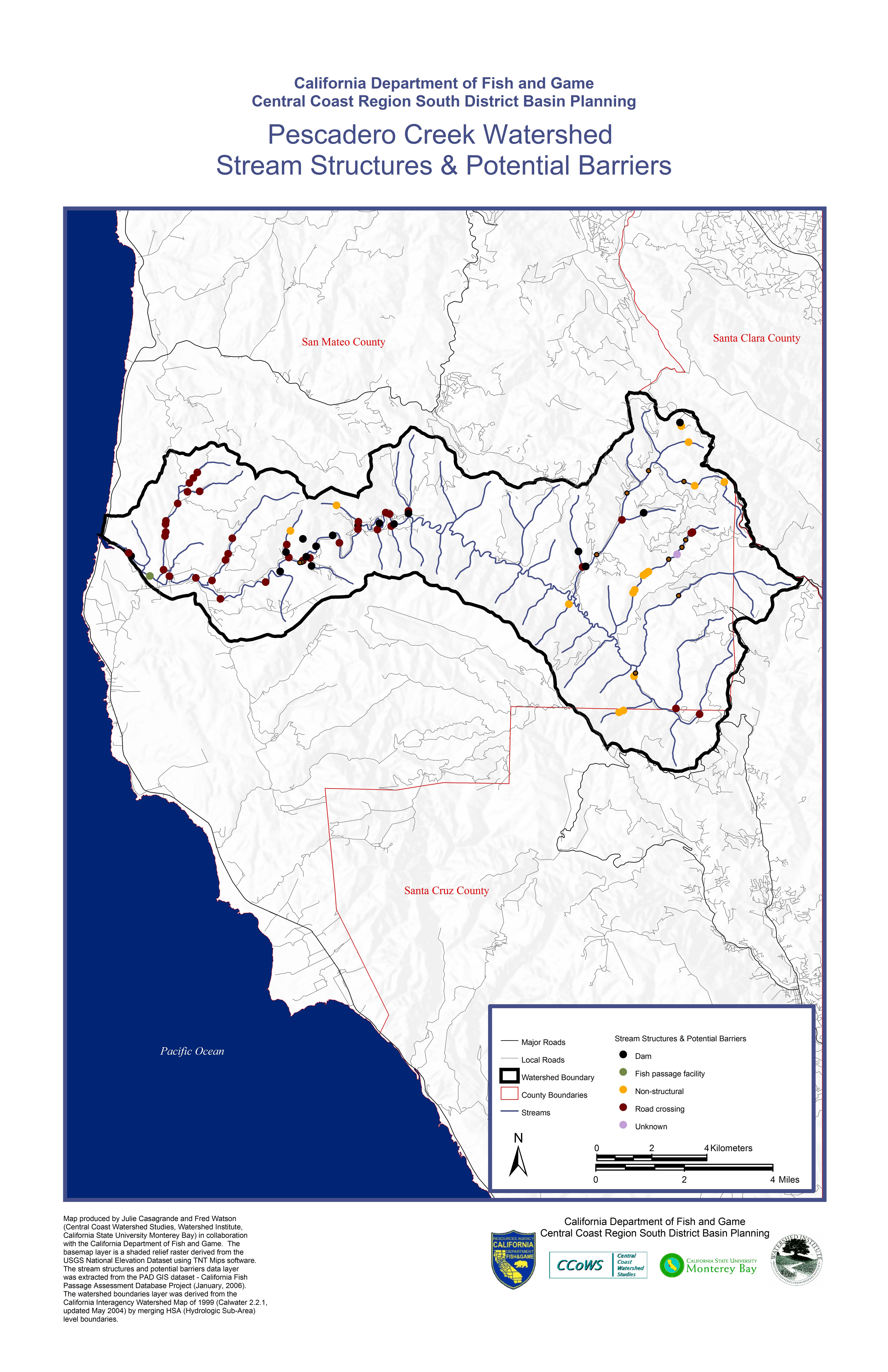
Stream Structures & Potential Barriers
|
jpeg |
Map produced by Julie Casagrande and Fred Watson (Central Coast Watershed Studies, Watershed Institute, California State University Monterey Bay) in collaboration with the California Department of Fish and Game. The basemap layer is a shaded relief raster derived from the USGS National Elevation Dataset using TNT Mips software. The stream structures and potential barriers data layer was extracted from the PAD GIS dataset California Fish Passage Assessment Database Project (January, 2006). The watershed boundaries layer was derived from the California Interagency Watershed Map of 1999 (Calwater 2.2.1,updated May 2004) by merging HSA (Hydrologic Sub-Area) level boundaries.
|
|
|
|
|
| Riparian Canopy Density |
jpeg |
Map produced by Julie Casagrande and Fred Watson (Central Coast Watershed Studies, Watershed Institute, California State University Monterey Bay) in collaboration with the California Department of Fish and Game. The data presented in map were collected during the CDFG Salmonid Habitat Surveys (Summer 1996). The basemap layer is a shaded relief raster derived from the USGS National Elevation Dataset using TNT Mips software. The watershed boundaries layer was derived from the California Interagency Watershed Map of 1999 (Calwater 2.2.1,updated May 2004) by merging HSA (Hydrologic Sub-Area) level boundaries.
|
|
|
|
|
Embeddedness |
jpeg |
Map produced by Julie Casagrande and Fred Watson (Central Coast Watershed Studies, Watershed Institute, California State University Monterey Bay) in collaboration with the California Department of Fish and Game. The data presented in map were collected during the CDFG Salmonid Habitat Surveys (Summer 1996). The basemap layer is a shaded relief raster derived from the USGS National Elevation Dataset using TNT Mips software. The watershed boundaries layer was derived from the California Interagency Watershed Map of 1999 (Calwater 2.2.1,updated May 2004) by merging HSA (Hydrologic Sub-Area)level boundaries.
|
|
|
|
|
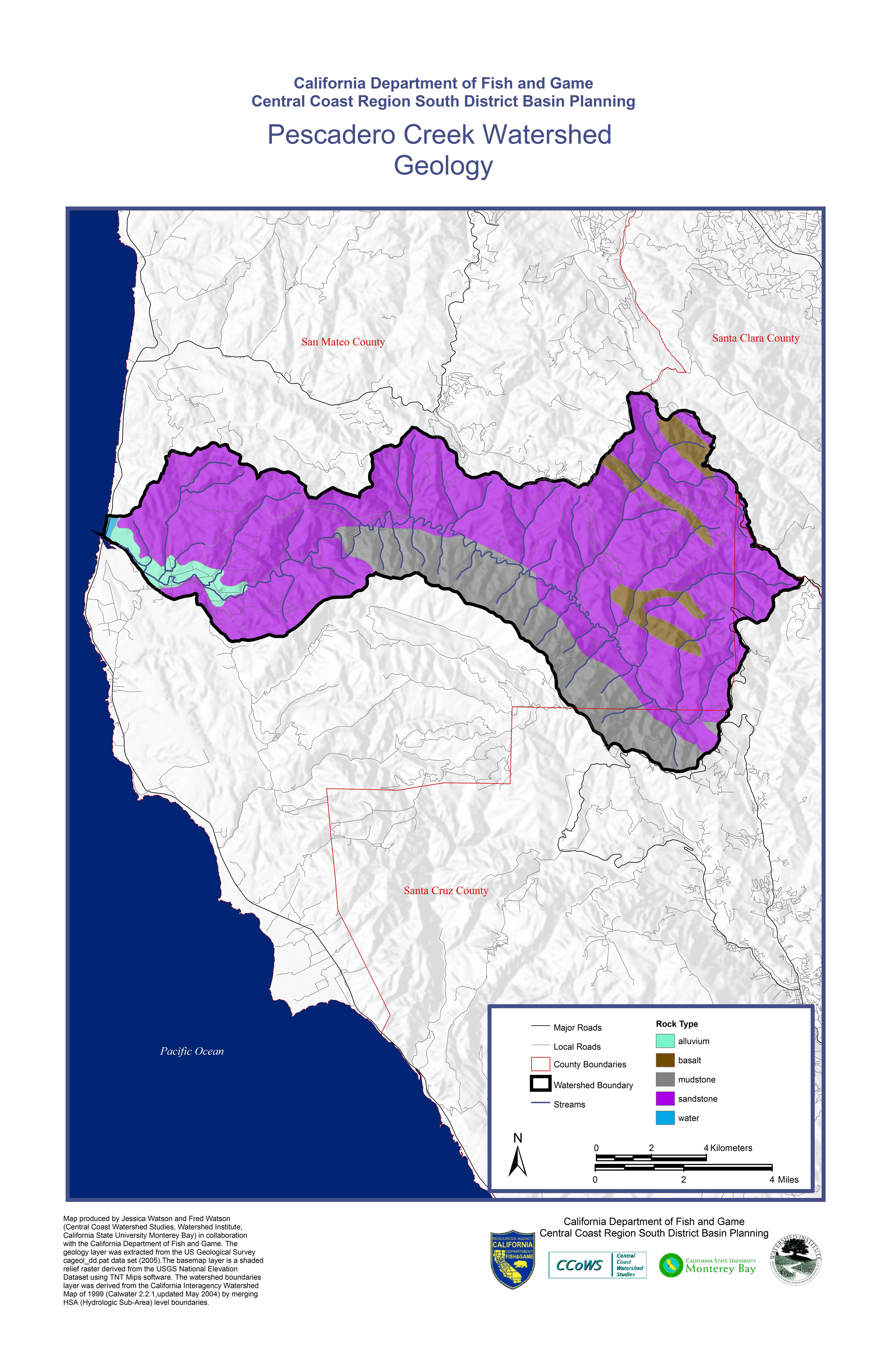
| Geology |
jpeg |
Map produced by Jessica Watson and Fred Watson(Central Coast Watershed Studies, Watershed Institute, California State University Monterey Bay) in collaborationwith the California Department of Fish and Game. The geology layer was extracted from the US Geological Survey cageol_dd.pat data set (2005).The basemap layer is a shaded relief raster derived from the USGS National Elevation Dataset using TNT Mips software. The watershed boundaries layer was derived from the California Interagency Watershed Map of 1999 (Calwater 2.2.1,updated May 2004) by merging HSA (Hydrologic Sub-Area) level boundaries.
|
|
|
|
|
| Habitat Level |
jpeg |
Map produced by Julie Casagrande and Fred Watson (Central Coast Watershed Studies, Watershed Institute, California State University Monterey Bay) in collaboration with the California Department of Fish and Game. The data presented in map were collected during the CDFG Salmonid Habitat Surveys (Summer 1996). The basemap layer is a shaded relief raster derived from the USGS National Elevation Dataset using TNT Mips software. The watershed boundaries layer was derived from the California Interagency Watershed Map of 1999 (Calwater 2.2.1,updated May 2004) by merging HSA (Hydrologic Sub-Area)level boundaries.
|
|
|
|
|
| Habitat Type |
jpeg |
Map produced by Jessica Watson and Fred Watson (Central Coast Watershed Studies, Watershed Institute, California State University Monterey Bay) in collaboration with the California Department of Fish and Game. The data presented in map were collected during the CDFG Salmonid Habitat Surveys (Summer 1996). The basemap layer is a shaded relief raster derived from the USGS National Elevation Dataset using TNT Mips software. The watershed boundaries layer was derived from the California Interagency Watershed Map of 1999 (Calwater 2.2.1,updated May 2004) by merging HSA (Hydrologic Sub-Area)level boundaries.
|
|
|
|
|
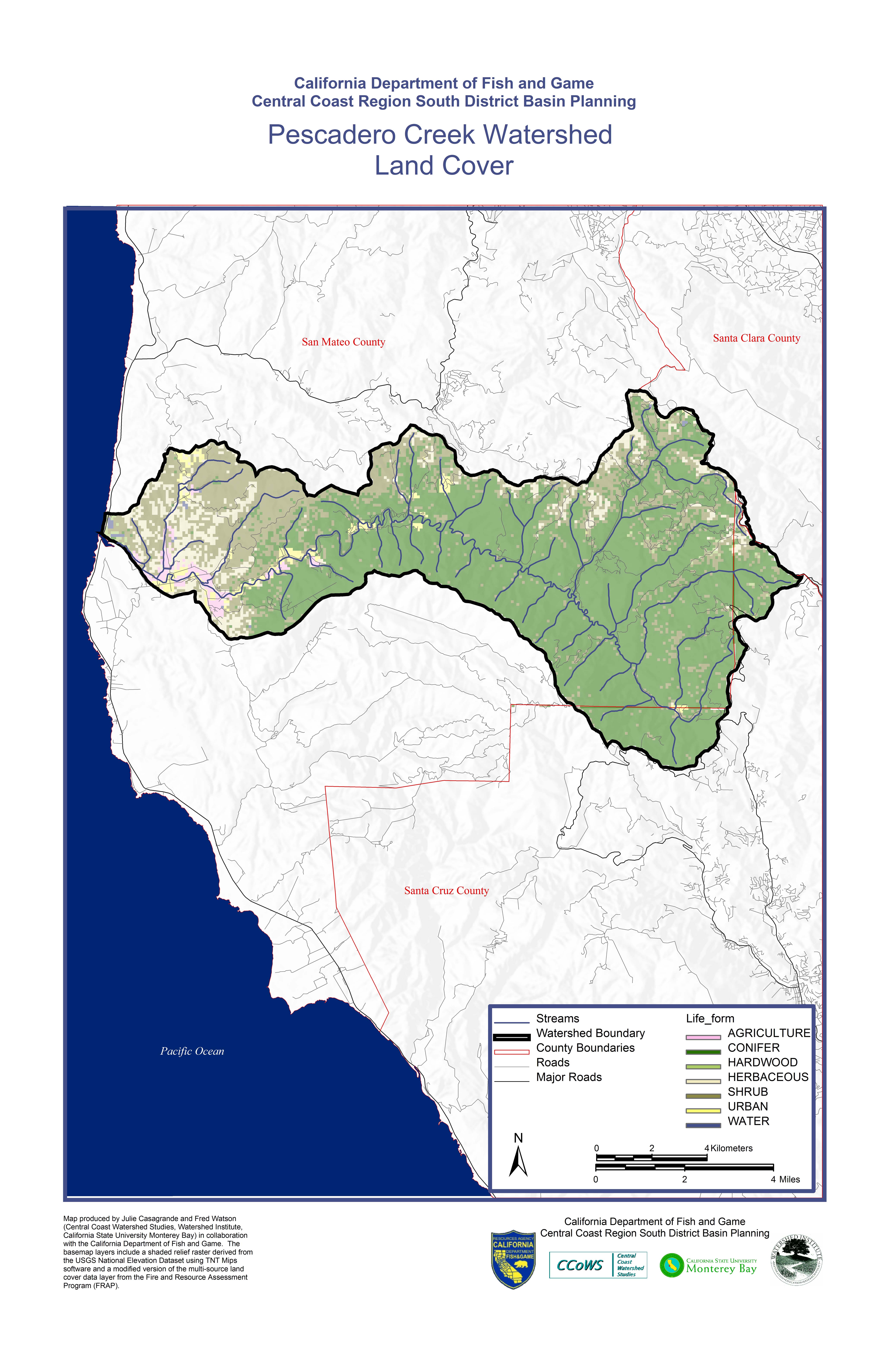
| Land Cover |
jpeg |
Map produced by Julie Casagrande and Fred Watson (Central Coast Watershed Studies, Watershed Institute, California State University Monterey Bay) in collaboration with the California Department of Fish and Game. The basemap layers include a shaded relief raster derived from the USGS National Elevation Dataset using TNT Mips software and a modified version of the multi source landcover data layer from the Fire Resource Assessment Program (FRAP). The watershed boundaries layer was derived from the California Interagency Watershed Map of 1999 (Calwater 2.2.1 updated May 2004) by merging HSA (Hydrologic Sub-Area) level boundaries.
|
|
|
|
|
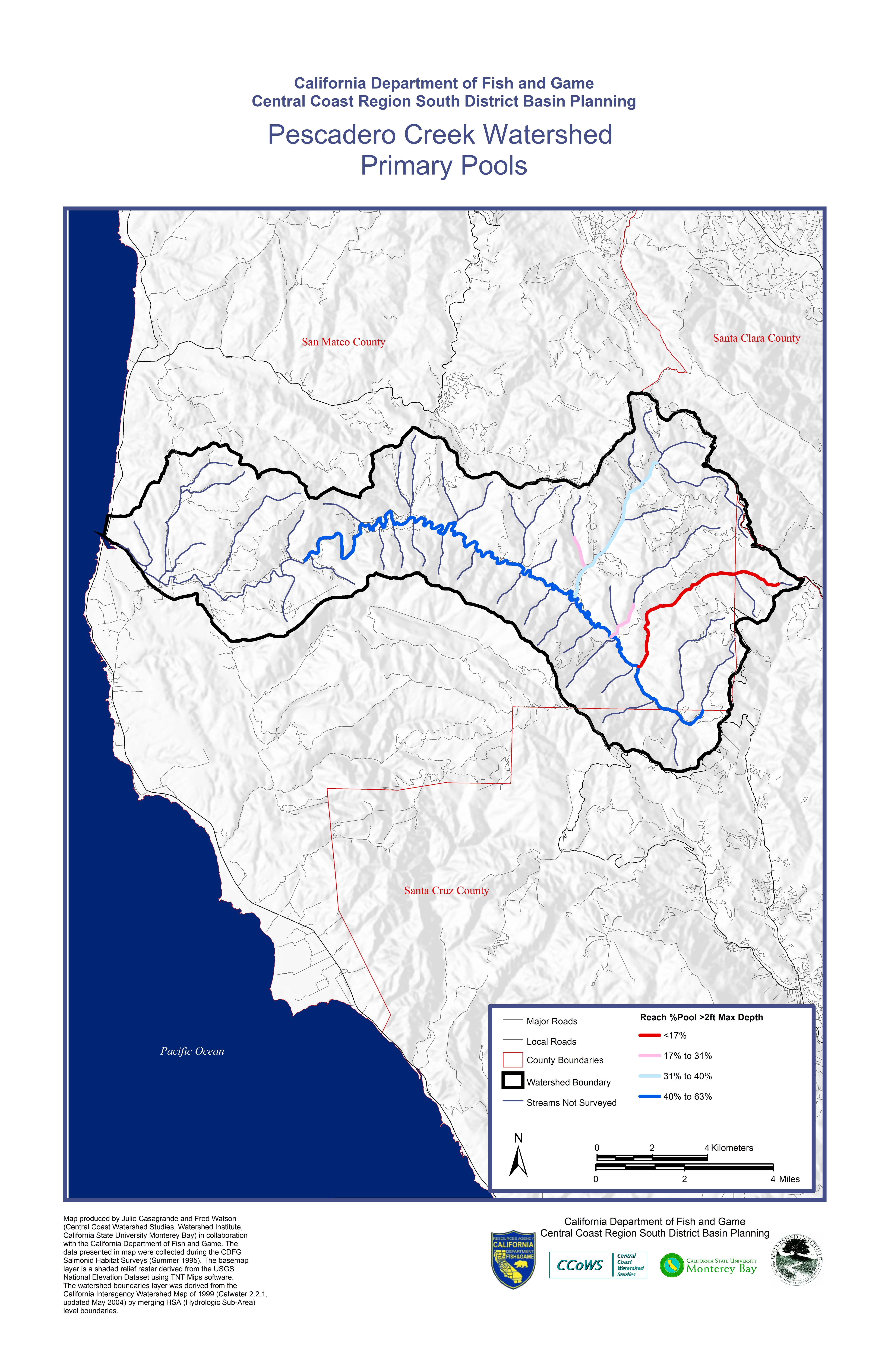
| Primary Pools |
jpeg |
Map produced by Julie Casagrande and Fred Watson (Central Coast Watershed Studies, Watershed Institute, California State University Monterey Bay) in collaboration with the California Department of Fish and Game. The data presented in map were collected during the CDFG Salmonid Habitat Surveys (Summer 1996). The basemap layer is a shaded relief raster derived from the USGS National Elevation Dataset using TNT Mips software. The watershed boundaries layer was derived from the California Interagency Watershed Map of 1999 (Calwater 2.2.1,updated May 2004) by merging HSA (Hydrologic Sub-Area)level boundaries. |
|
|
|
|
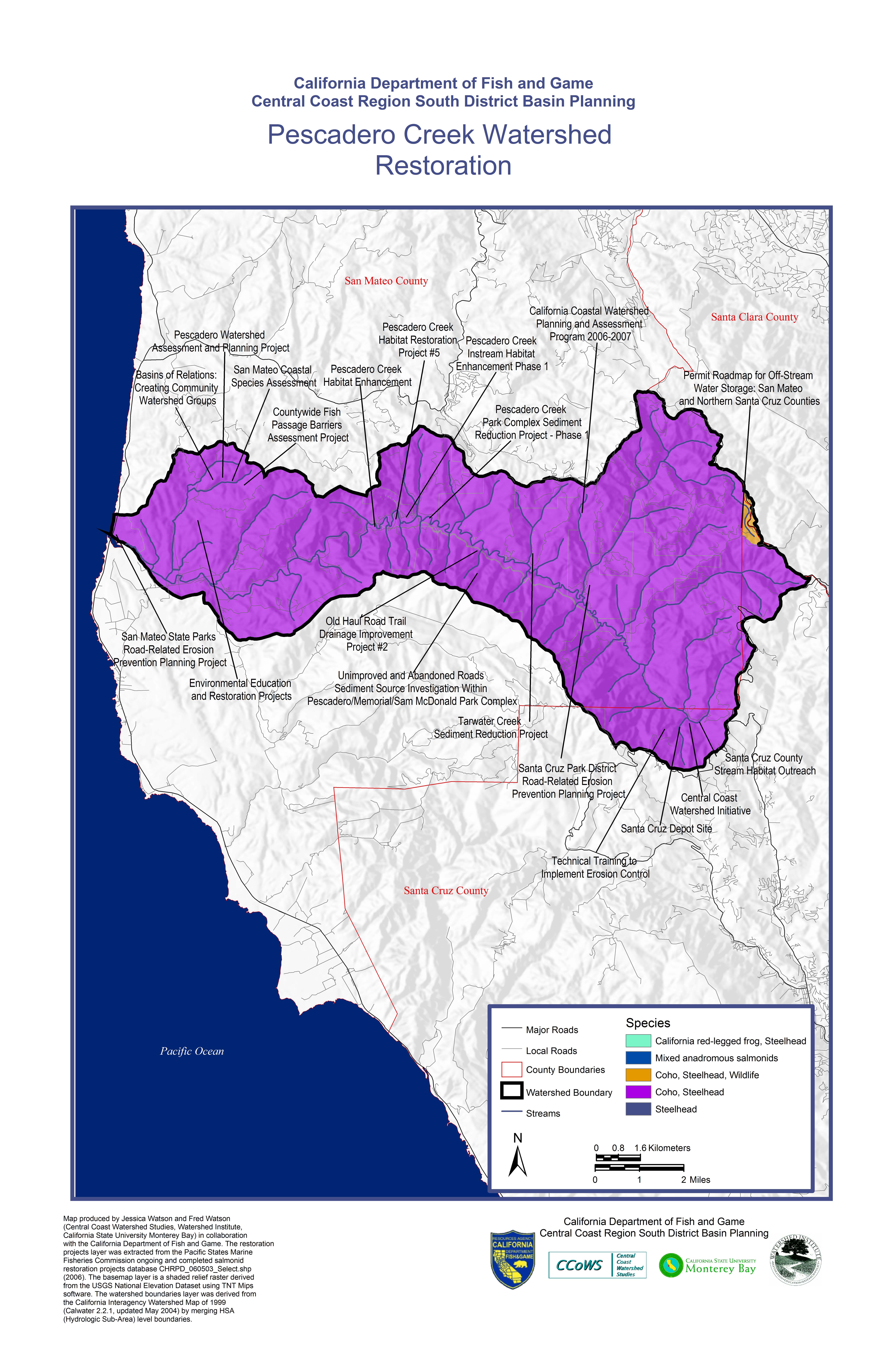
| Restoration Projects |
jpeg |
Map produced by Jessica Watson and Fred Watson (Central Coast Watershed Studies, Watershed Institute, California State University Monterey Bay) in collaboration with the California Department of Fish and Game. The restoration projects layer was extracted from the Pacific States Marine Fisheries Commission ongoing and completed salmonid restoration projects database CHRPD_060503_Select.shp (2006). The basemap layer is a shaded relief raster derived from the USGS National Elevation Dataset using TNT Mips software. The watershed boundaries layer was derived from the California Interagency Watershed Map of 1999 (Calwater 2.2.1, updated May 2004) by merging HSA (Hydrologic Sub-Area) level boundaries.
|
|
|
|
|
| Slope |
jpeg |
Map produced by Jessica Watson and Fred Watson (Central Coast Watershed Studies, Watershed Institute, California State University Monterey Bay) in collaboration with the California Department of Fish and Game. The slope data layer is an evlevation raster derived from the USGS National Elevation Dataset using TNT Mips software. The basemap layer is a shaded relief raster derived from the USGS National Elevation Dataset using TNT Mips software. The watershed boundaries layer was derived from the California Interagency Watershed Map of 1999 (Calwater 2.2.1,updated May 2004) by merging HSA (Hydrologic Sub-Area) level boundaries.
|
|
|
|
|
| Water Temperature |
jpeg |
Map produced by Julie Casagrande and Fred Watson
(Central Coast Watershed Studies, Watershed Institute,
California State University Monterey Bay) in collaboration with the California Department of Fish and Game. The data presented in map were collected during the CDFG Salmonid Habitat Surveys (Summer 1996). The basemap layer is a shaded relief raster derived from the USGS National Elevation Dataset using TNT Mips software. The watershed boundaries layer was derived from the California Interagency Watershed Map of 1999 (Calwater 2.2.1,updated May 2004) by merging HSA (Hydrologic Sub-Area)level boundaries. |
|
|
|
Download (75mb)
Right Click to Save |
| Passage Identification |
jpeg |
Map produced by Jessica Watson, William Perry, and Fred Watson (Central Coast Watershed Studies, Watershed Institute, California State University Monterey Bay) in collaboration with the California Department of Fish and Game. The basemap layer is a shaded relief raster derived from the USGS National Elevation Dataset using TNT Mips software. The passage classification data layer was created from Crossing Inventory and Fish Passage Evaluation for
California Department of Fish and Game.The watershed boundaries layer was derived from the California Interagency Watershed Map of 1999 (Calwater 2.2.1,updated May 2004) by merging HSA (Hydrologic Sub-Area) level boundaries. |
|
|
|
Download (75mb)
Right Click to Save |