Garrapata State Park
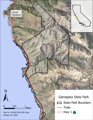
Garrapata State Park lies just over six miles south of Carmel in Monterey County, California. The park encompasses nearly 3,000 acres of land comprising sea bluff, rocky intertidal, and sandy beach to the west of Highway 1 and the steep foothills of the Santa Lucia Range to the east (Image 1). The park is dissected by Wildcat Creek, Malpaso Creek, Soberanes Creek, Doud Creek, and Granite Creek and elevation ranges from sea level to 2,011 ft.[1] Dissected by several faults, Garrapata State Park contains a mosaic of vertical sea stacks of sandstone and turbidite formations, shale, volcanic rocks, chert, and highly fractured granite. The park supports a variety of habitats including coastal scrub, maritime chaparral, and coast redwood stands and is home to the endangered Smith's blue butterfly and coast horned lizard as well as an assortment of birds and mammals.[2]
History
Garrapata State Park began as part of a large network of villages for the Ohlone and Esselen tribes. In the mid-to-late 1700s, Spanish missionaries began assuming control and claiming authority over the land and its resources.[3] By the 1830s, most of the land was being used for cattle grazing by a few ranchers, most notably Ezequiel Soberanes and Francis Doud. Ezequiel Soberanes prosperously ranched cattle and sheep on the land for 24 years until a land dispute resulted in the selling of the property to Francis Doud, an early resident of Monterey. Francis Doud successfully operated the Doud Ranch from 1891 until the early 1950s and in 1980, the state of California purchased its first parcel of the property. Five years later, the area was officially classified as a State Park.[2]
Recreation
Garrapata State Park encompasses Garrapata Beach at its southern-most end, providing visitors with leisurely beach-going opportunities. The park also includes several scenic hiking trails of varying intensities.
Recreation Trails
| Trail Name | Difficulty | Length (mi) | Elevation Gain (ft) | Est. Time (min) |
|---|---|---|---|---|
| Garrapata Bluff Trail | Easy | 0.6 | 49 | 16 |
| South Plateau-Mound Meadow Loop | Easy | 0.7 | 118 | 22 |
| Garrapata Beach: Calla Lily Valley | Easy | 1.1 | 150 | 30 |
| Soberanes Point and Whale Peak | Easy | 1.8 | 311 | 60 |
| Ridge/Soberanes Canyon Loop | Hard | 5.4 | 1,788 | 200 |
| Doud Peak Trail | Hard | 5.9 | 2,011 | 200 |
Management
References
- ↑ Perez-Jimenez J, Solis L, Bogdan M, McGee M, Brown R, Franklin L, Gautreaux S, Larson D, Robinson T, Schnieders J, Van Orman B, Walmsley E, Watson F. 2020. Mapping of vegetation communities, invasive plants, and sensitive plants at Garrapata State Park, Monterey County, California. Watershed Institute, California State University Monterey Bay, Publication No. WI-2020-03, 123 pp. http://ccows.csumb.edu/pubs/proj_pubs/2020/ENVS660_GarrapataSP/CSUMB_ENVS660_VegetationOfGarrapataSP_20201023b.pdf
- ↑ 2.0 2.1 Garrapata State Park Monterey Sector. 2003. Garrapata State Park brochure [Internet]. Sacramento (CA): California State Parks; [cited 2020 Oct 24]. https://www.parks.ca.gov/pages/579/files/Garrapata.pdf
- ↑ White C. 2001. Costanoan Rumsen Carmel Tribe history. http://crc.nativeweb.org/history.html
