Lower Salinas River Watershed
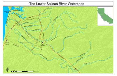
The Lower Salinas River Watershed is the name given by the Regional Water Quality Control Board Central Coast Region to the lower portion of the Salinas River and the Salinas Reclamation Canal. Although composed of several sub-watersheds, the name Lower Salinas River Watershed is commonly used to define the geographic scope of Total Maximum Daily Load (TMDL) projects in the region.
Disambiguation
The Salinas River starts in the La Panza Range, in San Luis Obispo County, and drains into the Salinas River Lagoon. At times of the year, the Salinas River also flows through a man-made canal, the Old Salinas River, into the Moss Landing Harbor.
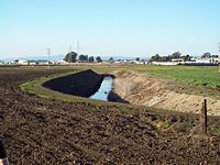
The waters from a smaller watershed, the Reclamation Canal (or Reclamation Ditch) watershed (also known as Gabilan Waterhed), also drain into the Moss Landing Harbor. For administrative purposes, the term Lower Salinas River Watershed is sometimes used to encompass both the lower portion of the Salinas River Watershed and the Reclamation Canal Watershed.
Location and Description
Located in Monterey County, the Lower Salinas River Watershed is the watershed area of the Salinas River from Gonzales Road downstream to its confluence with Moss Landing Harbor.
Surface water sources include precipitation, releases from reservoirs, groundwater, and return flows from agricultural irrigation. Mean annual precipitation in the area ranges from approximately 13 to 16 inches per year with the majority of precipitation occurring between November and April.
Land use in the project area includes intensive agriculture as well as the urban centers of Salinas, Castroville and Prunedale.
The Lower Salinas River Watershed area is characterized by both ephemeral and perennial stream reaches, as the Lower Salinas River runs dry during the summer months, and in comparison the lower Reclamation Ditch flows year-round.
Environmental Concerns
Several water bodies in both the Lower Salinas River watershed and in the Reclamation Canal Watershed have been listed as impaired under the Clean Water Act. The 2010 303(d) list of impaired water bodies in the Lower Salinas Watershed lists nineteen water bodies for nine different pollutant categories as follows:
| Water Body | Pollutant Category |
|---|---|
| Alisal Creek | Nutrients, Pathogens, Salinity |
| Alisal Slough | Nutrients, Toxicity |
| Blanco Drain | Nutrients, Pesticides, Sediment |
| Chualar Creek | Miscellaneous, Nutrients, Pathogens, Pesticides, Sediment, Toxicity |
| Esperanza Creek | Nutrients |
| Espinosa Slough | Miscellaneous, Nutrients, Other Organics, Pesticides, Sediment, Toxicity |
| Gabilan Creek | Miscellaneous, Nutrients, Pathogens, Sediment, Toxicity |
| Merrit Ditch | Nutrients, Sediment, Toxicity |
| Moro Cojo Slough | Miscellaneous, Nutrients, Pathogens, Pesticides, Sediment |
| Moss Landing Harbor | Metals/Metalloids, Miscellaneous, Nutrients, Pathogens, Pesticides, Sediment,Toxicity |
| Natividad Creek | Miscellaneous, Nutrients, Pathogens, Sediment, Toxicity |
| Old Salinas River | Miscellaneous, Nutrients, Pathogens, Pesticides, Sediment, Toxicity |
| Old Salinas River Estuary | Nutrients, Pesticides |
| Quail Creek | Miscellaneous, Nutrients, Pathogens, Pesticides, Sediment, Toxicity |
| Salinas Reclamation Canal | Nutrients, Other Organics, Pathogens, Pesticides, Sediment, Toxicity |
| Salinas River (lower, estuary to near Gonzales Rd
Crossing) |
Miscellaneous, Nutrients, Other Organics, Pathogens, Pesticides, Salinity, Sediment, Toxicity |
| Salinas River Lagoon (North) | Nutrients, Pesticides |
| Santa Rita Creek | Nutrients, Pathogens, Salinity, Sediment |
| Tembladero Slough | Miscellaneous, Nutrients, Pathogens, Pesticides, Sediment, Toxicity |
Links
- Conditional waiver of waste discharge requirements for irrigated lands
- TMDL
- TMDLs in the Monterey Bay Region of California
- Total Maximum Daily Load for Fecal Coliform for the Lower Salinas River Watershed, Monterey County, California
- Total Maximum Daily Load for Nutrients in Lower Salinas River Watershed, Monterey County, California
- Total Maximum Daily Loads for Chlorpyrifos and Diazinon in Lower Salinas River Watershed in Monterey County, California
- Lower Salinas River Watershed Nutrient TMDL - Implementation and Monitoring Progress

