Monterey Peninsula Regional Park District (MPRPD)
This wiki page was created by students in the ENVS 560/L Watershed Systems class at CSUMB.

Contents
Summary

The Monterey Peninsula Regional Park District (MPRPD) is a special district entrusted to acquire lands for preserving open space and providing recreational opportunities in the Monterey Bay Region. Since its inception in 1972, the MPRPD has protected approximately 13,050 acres of open space, accounting for 24 parks and open spaces. [3]. The MPRPD's vision is "to have several large well managed parks distributed regionally across the District, representing a variety of habitats, concurrently protecting our environment and enhancing our community’s health, recreational and environmental education opportunities." [4]
5-year strategic plan
The Monterey Peninsula Regional Park District Board of Directors released the 5-Year Strategic Plan in December 2015.[2] The Strategic Plan sets seven goals for 2016-2020:
- Stewardship of Parks and Open Space through Land Use and Conservation Planning
- Engaging People with Nature
- Enhance MPRPD’s Relevance to our Community District-wide
- Collaborative Partnerships
- Invest in Human Capital
- Maintain Financial Sustainability
- Review Items Considered but May Not be Completed in Next 5-Years
History and Structure
Monterey is known by residents and visitors for its natural beauty and unique landscapes. With anxiety of development threatening these areas, peninsula residents voted to create the Monterey Peninsula Regional Park District in 1972. [5]

Board of Directors
The District is governed by a five member Board of Directors. Each member is elected (during even years) from a distinct geographic area known as a "Ward." Board meetings are held on the second Wednesday of every month, and are open to the public in accordance with The Brown Act.
Funding
The Park District is funded by several sources. Two of these are property taxes and benefits assessment. MPRPD receives 1/2 percent of property taxes collected within the district.[5] Along with the allocation of property taxes, the MPRPD Parks, Open Space and Coastal Preservation benefit from the assessment district tax, originally passed by voters in 2004, which collects approximately $22/year per single family dwelling. The assessment district tax was renewed in 2016. [7] MPRPD also obtains funding from state and federal grant programs. For example, in the year ending in June 2017 MPRPD revenue totaled $3,689,571 from property taxes, $1,212,450 from assessment district, and $1,529,061 from grants.[8]
Classification of Open Space
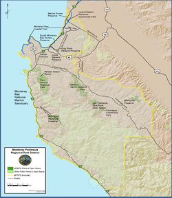
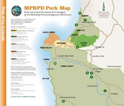
MPRPD acquired lands are classified as one of five types depending on the qualities and intended use of the open space:[5]
1. Regional Parks
- Regional parks are spacious land areas of at least 40 acres (or have potential to expand to 40 acres) with outstanding natural features for recreational and educational opportunities. Regional parks are managed for both recreation and protection, and consist of visitor serving facilities. MPRPD regional parks include:
- Garland Ranch Regional Park-Open to public
- Palo Corona Regional Park-Access by permit
2. Preserves
- Preserves are undeveloped land areas with endemic natural or cultural features. They differ from regional parks in that they are managed primarily for resource protection. While recreation is generally allowed, it may be limited or restricted due to fragile features. MPRPD preserves include:
- Blomquist Open Space Preserve-Access by permit
- Frog Pond Wetland Preserve-Open to public
- Laidlaw-Apte Pine Forest Preserve
- Joyce Stevens Preserve
- Mill Creek Redwood Preserve-Access by permit
- Marina Dunes Preserve-Open to public
- Eolian Dunes Preserve-Open to public
3. Trails
- A trail is a linear feature that provides a public access corridor through a natural or urban setting. Trails are to be managed for nonmotorized pedestrian, bicycle, equestrian, or a combination of uses. Trails shall provide a link between existing public or public access lands, other local trails, or urban communities. Trail construction and maintenance is a line item on the MPRPD budget and can be undertaken with agreement with local cities or sub-contractors.[9]
- Monterey Bay Coastal Trail
- Mill Creek Trail
- Other trails within Regional Parks and Preserves
4. Community Parks
- Community parks are smaller parcels than regional parks or preserves that are found in rural or urban communities and have recreational or open space potential. Community parks are managed to provide close to home community outdoor experiences that would otherwise be unavailable without assisstance from the District. Community parks include:
- Cachagua Community Park -Open to public
- Locke-Paddon Wetland Community Park -Open to public
5. Open Spaces
- Open spaces are undeveloped land with an undetermined purpose. Parcels are designated as open space only if they have the potential to become a future regional park, preserve, trail, or community park. No developments or improvements other that natural resource protection is permitted on open space lands. Open spaces include:
- San Clemente-Blue Rock Open Space-No public access
Projects
MBPRPD is involved in numerous projects in maintenance and rehabilitation of coastal land:
- The Palo Corona Regional Park General Development Plan[10] is scheduled to be released in the spring of 2018 and will guide future use and management of the 4,500 acre Palo Corona Regional Park at the mouth of Carmel Valley, which is currently limited to access by permit only.
Future Endeavors
- The MPRPD Board has voted to support the Fort Ord Rec Trail and Greenway (FORTAG).[11]
- There are reports that MPRPD has expressed interest in the CEMEX property, which will be available for restoration. MPRPD already owns land adjacent to the property. [12]
Collaboration with local agencies
The Palo Cornona Regional Park is a source of collaboration between MPRPD and several local agencies. The park hosts the California Condor Feeding Station in collaboration with the Ventana Wildlife Society.
Due to Palo Corona's opportunistic location between residential areas of the Monterey Bay and Big Sur, the park is a key component for connection of parklands in the region. In 2014, the MPRPD signed a Memorandum of Understanding with the Big Sur Land Trust, California State Parks and Point Lobos Foundation to work together on the Lobos-Corona Parklands Project. [13]
References
- ↑ MPRPD Location and Contact Information
- ↑ 2.0 2.1 MPRPD (2015). Strategic Plan 2016-2020.
- ↑ MPRPD, History
- ↑ MPRPD, Mission
- ↑ 5.0 5.1 5.2 MPRPD (1998). Master Plan
- ↑ MPRPD (2017). Let's Go Outdoors.
- ↑ Monterey County General Election. Measure E
- ↑ MPRPD Board of Directors Meeting January 2018
- ↑ MPRPD Board of Directors Meeting 2017
- ↑ MPRPD. Palo Corona General Development Plan, Timeline
- ↑ MPRPD Meeting Minutes October 2017
- ↑ Monterey County Weekly article on CEMEX closure
- ↑ Big Sur Land Trust, Lobos-Corona Parklands Project
Links
- Carmel River Floodplain Restoration and Environmental Enhancement (Carmel River FREE) Project
- MPRPD Planning and Conservation Documents
Disclaimer
This is not the official Monterey Peninsula Regional Park District page. This page may contain student work completed as part of assigned coursework. It may not be accurate. It does not necessary reflect the opinion or policy of CSUMB, its staff, or students.