Unmanned Aerial Vehicle (UAV) Regulation in California's Central Coast Region

An environmental issue examined by the ENVS 560/L Watershed Systems class at CSUMB.
Unmanned Aerial Vehicles (UAVs), also known as drones, are unmanned, aerial systems which typically include a ground-based controller, the drone itself, and a system of communication between the units[2]. The drone may be controlled directly by the operator or autonomously by onboard computers. The increase in hobby-drone ownership has prompted the Federal Aviation Administration (FAA) to require that all drones that weigh more than 250 grams be registered (Special Rule for Model Aircraft (Public Law 112-95 Section 336))[3]. The FAA is the only regulatory body that controls United States airspace, but individual cities, state and national parks have created their own rulings controlling drone launching and landing due to concerns over safety, privacy and wildlife disturbance.
Drones have been used regionally for data collection and conservation efforts[4]. There is also increased interest in the use of drones in agriculture and other commercial purposes[5].
Contents
FAA Rules Relating to Drones
Rules found on the FAA Frequently Asked Questions page.[1]
- Fly below 400 feet and remain clear of surrounding obstacles
- Keep the aircraft within visual line of sight at all times
- Remain clear of and do not interfere with manned aircraft operations (emergency response, fire response, etc.)
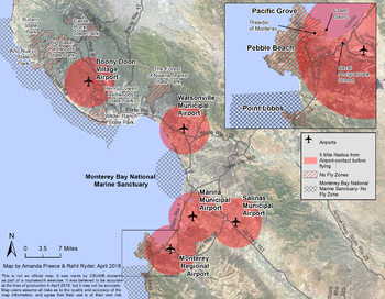
- Do not fly within 5 miles of an airport unless you contact the airport and control tower and obtain permission before flying
- Do not fly near people or stadiums
- Do not fly in adverse weather conditions such as in high winds or reduced visibility
- Do not fly under the influence of alcohol or drugs
- Do not fly an aircraft that weighs more than 55 lbs
- Do not fly near or over sensitive infrastructure or property such as power stations, water treatment facilities, correctional facilities, heavily traveled roadways, etc.
- Do not be careless or reckless with your unmanned aircraft, you could be fined for endangering people or other aircraft
- Do not conduct surveillance or photograph persons in areas where there is an expectation of privacy without the individual’s permission
- Check and follow all local laws and ordinances before flying over private property
Central Coast Laws
- It is illegal to launch, land or operate a drone within National Park Service Lands (i.e. Pinnacles National Park)[6].
- It is illegal to fly drones over the Monterey Bay National Marine Sanctuary (MBNMS) in the Restricted Overflight Zones[7].
- Santa Cruz District California State Parks do not allow drone operation within their parks[8].
- Monterey District California State Parks don't have regulations expressly against operating drones within their parks, but rangers can choose to enforce the Games and Recreational Activities (14 CCR § 4319) code. This states that "No person shall engage in games or recreational activities that endanger the safety of persons, property, resources, or interfere with visitor activities except as permitted by the Department" [9].
- It is illegal to operate a drone at Point Lobos, which is a State Natural Reserve. Even though it is part of the Monterey State Park district, State Natural Reserves have extra protection[10].
- It is illegal to fly over any United States Armed Forces properties (Presidio, Defense Language Institute, Naval Postgraduate School, Coast Guard housing and Army controlled lands in Ft. Ord).
- Commercial drone operators, registered as such through the FAA's Small UAS Rule (14 CFR part 107)[11] typically need a permit to do any filming for commercial purposes and must obtain a filming permit from the California Film Commission[12].
City of Del Rey Oaks
Lies within the five-mile radius around the Monterey Regional Airport, which requires drone operators obtain permission to fly from air traffic control tower.
City of Marina
Lies within a five-mile radius of the Marina Municipal Airport and drone operators must obtain permission to fly from the airport. The Marina Municipal Airport is currently home to the Naval Postgraduate School (NPS) Center for Interdisciplinary Remotely-Piloted Aircraft Studies (NPS/CIRPAS) and is in talks to become an FAA Unmanned Aerial System Integration Pilot Program (UASIPP) site[13]. Obtaining this designation would allow for advanced UAV integration work to proceed at this location.
City of Monterey
Lies within the five-mile radius around the Monterey Regional Airport, which requires drone operators to obtain permission to fly from the air traffic control tower. Additional rules fall under Monterey Municipal Code Sec. 23-6: Flying Remote Control Models. In this case, drones are considered "models" and cannot be flown in any park, playground, beach, or public recreation area.
City of Pacific Grove
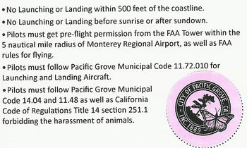
Pacific Grove Municipal Code 11.72.010 states "It is unlawful to launch or land an aircraft, including a helicopter, drone or other unmanned aircraft, without a permit". Drone operators may apply for a permit from the city offices. Permit applications can be accessed on the city website[14]. The permit says "Upon review of the application, other stipulations to the permit may apply. Please do not disturb the wildlife. Permits must be received within 3 working days. Annual permit fees are $80, daily permit fees are $20". The initiation of a city code pertaining to drone use came up through an effort by local wildlife advocates who were concerned about excessive drone use seen around the Point Pinos area of Pacific Grove. Incidences with drones harassing Harbor Seals at their pupping sites and nesting Black Oystercatchers prompted residents to take action.
Community of Pebble Beach
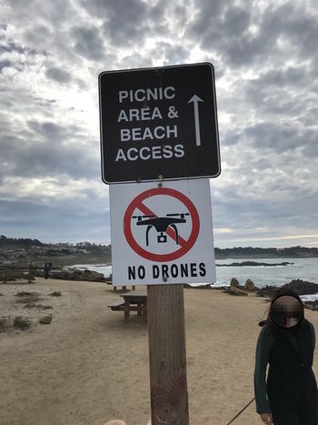
Signs along the walking paths and coastal areas of Pebble Beach indicate that drones are not permitted.
City of Sand City
Lies within the five-mile radius around the Monterey Regional Airport, which requires drone operators to obtain permission to fly from the air traffic control tower.
City of Seaside
Lies in the overlap-zone of both the Marina Municipal Airport and the Monterey Regional Airport. Drone operators must obtain permission to fly from both air traffic control towers before flying.
References
- ↑ 1.0 1.1 FAA. Unmanned Aircraft Systems (UAS) Frequently Asked Questions. Retrieved 5 April 2018. https://www.faa.gov/uas/faqs/
- ↑ International Civil Aviation Organization Cir 328 AN/190 : Unmanned Aircraft Systems (PDF). ICAO. Retrieved 5 April 2018. https://www.icao.int/Meetings/UAS/Documents/Circular%20328_en.pdf
- ↑ U.S. Department of Transportation, Federal Aviation Administration. Interpretation of the Special Rule for Model Aircraft (PDF). Retrieved 5 April 2018. https://www.faa.gov/uas/media/model_aircraft_spec_rule.pdf
- ↑ Conservation Drones projects in US, Australia, Switzerland and UK. Retrieved 5 April 2018. https://conservationdrones.org/
- ↑ Michael Mazur. "Six Ways Drones Are Revolutionizing Agriculture". Retrieved 5 April 2018. https://www.technologyreview.com/s/601935/six-ways-drones-are-revolutionizing-agriculture/
- ↑ National Park Service. "Unmanned Aircraft in the National Parks". Retrieved 5 April 2018. https://www.nps.gov/articles/unmanned-aircraft-in-the-national-parks.htm
- ↑ MBNMS. Resource Issues: Aircraft, Model Aircraft, & Drones. Retrieved 5 April 2018. https://montereybay.noaa.gov/resourcepro/resmanissues/aircraft.html
- ↑ Rebecca Greenway. NBC Bay Area News."Local Park Orders Prohibit Drones on California State Parks and Beaches in San Mateo County" Retrieved 5 April 2018.https://www.nbcbayarea.com/news/local/Where-to-Drone-in-the-Bay-Area-and-What-to-Know-Before-You-Fly-427297153.html
- ↑ OFFICIAL CALIFORNIA CODE OF REGULATIONS Retrieved 9 April 2018.https://govt.westlaw.com/calregs/Document/IAD015C60D48511DEBC02831C6D6C108E?viewType=FullText&originationContext=documenttoc&transitionType=CategoryPageItem&contextData=(sc.Default)
- ↑ CA State Parks. Unmanned Aircraft System (Drones) in State Parks. Retrieved 5 April 2018.https://www.parks.ca.gov/?page_id=29229
- ↑ Fly under the Small UAS Rule: Remote Pilot Certification. Retrieved 9 April 2018. https://www.faa.gov/uas/getting_started/part_107/
- ↑ California Film Commission. UAS – Filming with Drones. Retrieved 5 April 2018. http://film.ca.gov/state-permits/uas-filming-with-drones/
- ↑ Josh Metz. "UASIPP at Marina Airport" Retrieved 5 April 2018. http://ordforward.org/uasipp-marina-airport/
- ↑ City of Pacific Grove Drone Permit Application Retrieved 6 April 2018. https://www.cityofpacificgrove.org/sites/default/files/forms/police/dronepermitapplication_1.pdf
Disclaimer
This page may contain student work completed as part of assigned coursework. It may not be accurate. It does not necessary reflect the opinion or policy of CSUMB, its staff, or students


