Difference between revisions of "California Central Coast Gage Locations"
From CCoWS Wiki
(→Flow Gaging Sites) |
(→Flow Gaging Sites) |
||
| (37 intermediate revisions by 6 users not shown) | |||
| Line 1: | Line 1: | ||
| + | An [[Summaries of Environmental Topics on the Central Coast of California|environmental summary]] created by the [[ENVS 560/L Watershed Systems]] class at [[CSUMB]]. | ||
| + | |||
== Flow Gaging Sites == | == Flow Gaging Sites == | ||
| Line 13: | Line 15: | ||
| '''Watershed area''' | | '''Watershed area''' | ||
| '''See also''' | | '''See also''' | ||
| + | |- | ||
| + | | Canyon del Rey | ||
| + | | Arroyo Del Rey near city hall | ||
| + | | ... | ||
| + | | [[MPWMD]] | ||
| + | | 604058.76 | ||
| + | | 4050452.51 | ||
| + | | 36.59388889,-121.83666667 | ||
| + | | 11143300 | ||
| + | | Del Rey Oaks City Hall | ||
| + | | ... | ||
| + | | ... | ||
|- | |- | ||
| Carmel | | Carmel | ||
| Los Padres Reservoir | | Los Padres Reservoir | ||
| − | | | + | | CAR-LPD |
| ... | | ... | ||
| 619375 | | 619375 | ||
| − | | | + | | 4027569 |
| − | | | + | | 36.386227,-121.669033 |
| ... | | ... | ||
| − | | | + | | Los Padres Dam |
| − | | 116.04 | + | | 116.04 km<sup>2</sup> |
| ... | | ... | ||
|- | |- | ||
| Carmel | | Carmel | ||
| Former San Clemente Dam | | Former San Clemente Dam | ||
| + | | CAR-SCD | ||
| ... | | ... | ||
| + | | 615757 | ||
| + | | 4033150 | ||
| + | | 36.435696,-121.708680 | ||
| ... | | ... | ||
| − | | | + | | Former San Clemente Dam |
| − | + | | 131.1 km<sup>2</sup> | |
| − | + | ||
| − | + | ||
| − | + | ||
| − | | 131.1 km | + | |
| ... | | ... | ||
|- | |- | ||
| Line 44: | Line 58: | ||
| 613850 | | 613850 | ||
| 4080418 | | 4080418 | ||
| − | | | + | | 36.861965,-121.722738 |
| ... | | ... | ||
| ... | | ... | ||
| Line 56: | Line 70: | ||
| 615198 | | 615198 | ||
| 4080109 | | 4080109 | ||
| − | | | + | | 36.859882,-121.707658 |
| ... | | ... | ||
| ... | | ... | ||
| Line 68: | Line 82: | ||
| 619595 | | 619595 | ||
| 4027901 | | 4027901 | ||
| + | | ... | ||
| ... | | ... | ||
| ... | | ... | ||
| Line 75: | Line 90: | ||
| Carmel | | Carmel | ||
| [http://www.mpwmd.dst.ca.us/wrd/riverflows/2009/wy2009_sh.htm Carmel River at Sleepy Hollow Weir] | | [http://www.mpwmd.dst.ca.us/wrd/riverflows/2009/wy2009_sh.htm Carmel River at Sleepy Hollow Weir] | ||
| − | | | + | | CAR-SHW |
| [[MPWMD]] | | [[MPWMD]] | ||
| 615562 | | 615562 | ||
| 4034093 | | 4034093 | ||
| − | | | + | | 36.444923,-121.710265 |
| ... | | ... | ||
| ... | | ... | ||
| + | | 1.6 km<sup>2</sup> | ||
| ... | | ... | ||
|- | |- | ||
| Carmel | | Carmel | ||
| [http://waterdata.usgs.gov/nwis/uv?cb_00060=on&cb_00065=on&format=gif_default&period=60&site_no=11143200 Carmel River at Robles del Rio] | | [http://waterdata.usgs.gov/nwis/uv?cb_00060=on&cb_00065=on&format=gif_default&period=60&site_no=11143200 Carmel River at Robles del Rio] | ||
| − | | CAR-ESQ | + | | CAR-ESQ <ref>[https://docs.google.com/spreadsheets/d/1pXhdLTwr2KmIfhNMHlPaqUDJMy815J5_r22RKDu7Lzk/edit#gid=1416314251 Additional Gage Information] </ref> |
| + | |||
| [[USGS]] | | [[USGS]] | ||
| 613917 | | 613917 | ||
| − | | | + | | 4037265 |
| − | | | + | | 36.475624,-121.726726 |
| 11143200 | | 11143200 | ||
| Carmel Valley Village | | Carmel Valley Village | ||
| − | | | + | | 171.5 km<sup>2</sup> |
| [[CDEC]] site RDR | | [[CDEC]] site RDR | ||
|- | |- | ||
| Carmel | | Carmel | ||
| [http://www.mpwmd.dst.ca.us/wrd/riverflows/2009/wy2009_dj.htm Carmel River at Don Juan Bridge (Garland Park)] | | [http://www.mpwmd.dst.ca.us/wrd/riverflows/2009/wy2009_dj.htm Carmel River at Don Juan Bridge (Garland Park)] | ||
| − | | | + | | CAR-DJB |
| [[MPWMD]] | | [[MPWMD]] | ||
| − | | | + | | 610454 |
| − | | | + | | 4041156 |
| − | | | + | | 36.508410,-121.764001 |
| DJ | | DJ | ||
| Garland Park | | Garland Park | ||
| − | | . | + | | 55.2 km<sup>2</sup> |
| ... | | ... | ||
|- | |- | ||
| Line 113: | Line 130: | ||
| [[USGS]] | | [[USGS]] | ||
| 601108 | | 601108 | ||
| − | | | + | | 4044072 |
| − | | | + | | 36.538168,-121.875464 |
| 11143250 | | 11143250 | ||
| Via Mallorca Rd | | Via Mallorca Rd | ||
| − | | | + | | 77.7 km<sup>2</sup> |
| [[CDEC]] site CML | | [[CDEC]] site CML | ||
|- | |- | ||
| Line 126: | Line 143: | ||
| 597353.47 | | 597353.47 | ||
| 4043981.92 | | 4043981.92 | ||
| − | | | + | | 36.536014,-121.911777 |
| H1 | | H1 | ||
| ... | | ... | ||
| − | | | + | | 21.8 km<sup>2</sup> |
| [[CDEC]] site CMR | | [[CDEC]] site CMR | ||
|- | |- | ||
| Line 145: | Line 162: | ||
| Carmel | | Carmel | ||
| Pine Creek | | Pine Creek | ||
| − | | | + | | PIN-PIN |
| [[MPWMD]] | | [[MPWMD]] | ||
| 617316 | | 617316 | ||
| 4029858<ref>Approx, from map in Croyle's thesis.</ref> | | 4029858<ref>Approx, from map in Croyle's thesis.</ref> | ||
| − | | | + | | 36.407982,-121.693150 |
| PI | | PI | ||
| San Clemente Reservoir | | San Clemente Reservoir | ||
| − | | 19.9 | + | | 19.9 km<sup>2</sup> |
| ... | | ... | ||
|- | |- | ||
| Carmel | | Carmel | ||
| Finch Creek | | Finch Creek | ||
| − | | | + | | FIN-FIN |
| [[MPWMD]] | | [[MPWMD]] | ||
| − | | | + | | 628688 |
| − | | | + | | 4026942 |
| − | | | + | | 36.386534,-121.668855 |
| ... | | ... | ||
| Hastings Reservation Rd bridge | | Hastings Reservation Rd bridge | ||
| − | | 57.5 km | + | | 57.5 km<sup>2</sup> |
| ... | | ... | ||
|- | |- | ||
| Line 208: | Line 225: | ||
| ... | | ... | ||
| [[CDEC]] site [http://cdec.water.ca.gov/cgi-progs/queryF?SLG SLG]] | | [[CDEC]] site [http://cdec.water.ca.gov/cgi-progs/queryF?SLG SLG]] | ||
| + | |- | ||
|} | |} | ||
| + | |||
| + | '''Note:''' Easting/Northing, Lat/Long, and Watershed Area are all estimates. Watershed Area will vary depending on how many gages are used in a study. | ||
| + | |||
| + | '''Note:''' All latitudes are degrees north and all longitudes are degrees west. | ||
== Precipitation Gages == | == Precipitation Gages == | ||
| Line 216: | Line 238: | ||
| '''Gage name''' | | '''Gage name''' | ||
| '''Data Logger''' | | '''Data Logger''' | ||
| − | | ''' | + | | '''Recording Interval''' |
| '''Source''' | | '''Source''' | ||
| '''Coordinates''' | | '''Coordinates''' | ||
| Line 282: | Line 304: | ||
| Pajaro | | Pajaro | ||
| CR10 | | CR10 | ||
| − | | | + | | Hourly |
| [[CIMIS]] | | [[CIMIS]] | ||
| 36.902778,-121.741931 | | 36.902778,-121.741931 | ||
| Line 293: | Line 315: | ||
| Watsonville West II | | Watsonville West II | ||
| CR10 | | CR10 | ||
| − | | | + | | Hourly |
| [[CIMIS]] | | [[CIMIS]] | ||
| 36.913083,-121.823653 | | 36.913083,-121.823653 | ||
| Line 304: | Line 326: | ||
| Green Valley Road | | Green Valley Road | ||
| CR10 | | CR10 | ||
| − | | | + | | Hourly |
| [[CIMIS]] | | [[CIMIS]] | ||
| 36.943964,-121.763942 | | 36.943964,-121.763942 | ||
| Line 315: | Line 337: | ||
| Castroville | | Castroville | ||
| CR10 | | CR10 | ||
| − | | | + | | Hourly |
| [[CIMIS]] | | [[CIMIS]] | ||
| 36.768167,-121.773636 | | 36.768167,-121.773636 | ||
| Line 326: | Line 348: | ||
| Gilroy | | Gilroy | ||
| CR1000 | | CR1000 | ||
| − | | | + | | Hourly |
| [[CIMIS]] | | [[CIMIS]] | ||
| 37.015026,-121.53704 | | 37.015026,-121.53704 | ||
| Line 337: | Line 359: | ||
| San Juan Valley | | San Juan Valley | ||
| CR10 | | CR10 | ||
| − | | | + | | Hourly |
| [[CIMIS]] | | [[CIMIS]] | ||
| 36.822861,-121.467869 | | 36.822861,-121.467869 | ||
| Line 348: | Line 370: | ||
| San Benito | | San Benito | ||
| CR10 | | CR10 | ||
| − | | | + | | Hourly |
| [[CIMIS]] | | [[CIMIS]] | ||
| 36.854833,-121.362753 | | 36.854833,-121.362753 | ||
| Line 359: | Line 381: | ||
| Pajaro River at Chittenden | | Pajaro River at Chittenden | ||
| Tipping Bucket | | Tipping Bucket | ||
| − | | | + | | Event |
| [[CDEC]] | | [[CDEC]] | ||
| − | | 36. | + | | 36.900230,-121.597725 |
| 82 | | 82 | ||
| [http://cdec.water.ca.gov/cgi-progs/staMeta?station_id=CHT CHT] | | [http://cdec.water.ca.gov/cgi-progs/staMeta?station_id=CHT CHT] | ||
| Line 370: | Line 392: | ||
| Pleasant Valley | | Pleasant Valley | ||
| Tipping Bucket | | Tipping Bucket | ||
| − | | | + | | Event |
| [[CDEC]] | | [[CDEC]] | ||
| − | | 36. | + | | 36.989700,-121.830600 |
| 360 | | 360 | ||
| [http://cdec.water.ca.gov/cgi-progs/staMeta?station_id=PLV PLV] | | [http://cdec.water.ca.gov/cgi-progs/staMeta?station_id=PLV PLV] | ||
| Line 381: | Line 403: | ||
| Corralitos Creek at Freedom | | Corralitos Creek at Freedom | ||
| Tipping Bucket | | Tipping Bucket | ||
| − | | | + | | Event |
| [[CDEC]] | | [[CDEC]] | ||
| − | | 36. | + | | 36.939200,-121.769200 |
| 100 | | 100 | ||
| [http://cdec.water.ca.gov/cgi-progs/staMeta?station_id=CCF CCF] | | [http://cdec.water.ca.gov/cgi-progs/staMeta?station_id=CCF CCF] | ||
| Line 394: | Line 416: | ||
| Hourly | | Hourly | ||
| [[CDEC]] | | [[CDEC]] | ||
| − | | 36. | + | | 36.992000,-121.797000 |
| 450 | | 450 | ||
| [http://cdec.water.ca.gov/cgi-progs/staMeta?station_id=COR COR] | | [http://cdec.water.ca.gov/cgi-progs/staMeta?station_id=COR COR] | ||
| Line 403: | Line 425: | ||
| Salinas North | | Salinas North | ||
| CR10 | | CR10 | ||
| − | | | + | | Hourly |
| [[CIMIS]] | | [[CIMIS]] | ||
| 36.716806,-121.691889 | | 36.716806,-121.691889 | ||
| Line 414: | Line 436: | ||
| Soquel Creek | | Soquel Creek | ||
| Accummulated Precipitation | | Accummulated Precipitation | ||
| − | | | + | | Daily |
| [[CDEC]] | | [[CDEC]] | ||
| − | | 36. | + | | 36.983000,-121.950000 |
| 30 | | 30 | ||
| [http://cdec.water.ca.gov/cgi-progs/staMeta?station_id=SQL SQL] | | [http://cdec.water.ca.gov/cgi-progs/staMeta?station_id=SQL SQL] | ||
| Line 425: | Line 447: | ||
| De Laveaga | | De Laveaga | ||
| CR10 | | CR10 | ||
| − | | | + | | Hourly |
| [[CIMIS]] | | [[CIMIS]] | ||
| 36.997444,-121.996758 | | 36.997444,-121.996758 | ||
| Line 447: | Line 469: | ||
| Arroyo Seco | | Arroyo Seco | ||
| CR10 | | CR10 | ||
| − | | | + | | Hourly |
| [[CIMIS]] | | [[CIMIS]] | ||
| 36.347306,-121.29135 | | 36.347306,-121.29135 | ||
| Line 458: | Line 480: | ||
| Arroyo Seco | | Arroyo Seco | ||
| Accummulated Precipication | | Accummulated Precipication | ||
| − | | | + | | Hourly |
| [[CDEC]] | | [[CDEC]] | ||
| − | | 36. | + | | 36.230000,-121.488000 |
| 980 | | 980 | ||
| [http://cdec.water.ca.gov/cgi-progs/staMeta?station_id=ARY ARY] | | [http://cdec.water.ca.gov/cgi-progs/staMeta?station_id=ARY ARY] | ||
| Line 471: | Line 493: | ||
| Daily | | Daily | ||
| [[CDEC]] | | [[CDEC]] | ||
| − | | 36. | + | | 36.590557,-121.847504 |
| 217 | | 217 | ||
| [http://cdec.water.ca.gov/cgi-progs/staMeta?station_id=MTY MTY] | | [http://cdec.water.ca.gov/cgi-progs/staMeta?station_id=MTY MTY] | ||
| Line 480: | Line 502: | ||
| Carmel | | Carmel | ||
| CR10 | | CR10 | ||
| − | | | + | | Hourly |
| [[CIMIS]] | | [[CIMIS]] | ||
| 36.540889,-121.881958 | | 36.540889,-121.881958 | ||
| Line 491: | Line 513: | ||
| Ponciano Ridge | | Ponciano Ridge | ||
| Tipping Bucket | | Tipping Bucket | ||
| − | | | + | | Event |
| [[CDEC]] | | [[CDEC]] | ||
| − | | | + | | 36.4000,-121.7230 |
| 2610 | | 2610 | ||
| [http://cdec.water.ca.gov/cgi-progs/staMeta?station_id=PNR PNR] | | [http://cdec.water.ca.gov/cgi-progs/staMeta?station_id=PNR PNR] | ||
| Line 502: | Line 524: | ||
| Ventana Cone | | Ventana Cone | ||
| Tipping Bucket | | Tipping Bucket | ||
| − | | | + | | Event |
| [[CDEC]] | | [[CDEC]] | ||
| − | | 36. | + | | 36.300000,-121.714000 |
| 4750 | | 4750 | ||
| [http://cdec.water.ca.gov/cgi-progs/staMeta?station_id=VTC VTC] | | [http://cdec.water.ca.gov/cgi-progs/staMeta?station_id=VTC VTC] | ||
| Line 513: | Line 535: | ||
| Chews Ridge | | Chews Ridge | ||
| Tipping Bucket | | Tipping Bucket | ||
| − | | | + | | Event |
| [[CDEC]] | | [[CDEC]] | ||
| − | | 36. | + | | 36.312000,-121.570000 |
| 5040 | | 5040 | ||
| [http://cdec.water.ca.gov/cgi-progs/staMeta?station_id=CHW CHW] | | [http://cdec.water.ca.gov/cgi-progs/staMeta?station_id=CHW CHW] | ||
| Line 526: | Line 548: | ||
| Hourly | | Hourly | ||
| [[CDEC]] | | [[CDEC]] | ||
| − | | 36. | + | | 36.358000,-121.542000 |
| 2230 | | 2230 | ||
| [http://cdec.water.ca.gov/cgi-progs/staMeta?station_id=CAH CAH] | | [http://cdec.water.ca.gov/cgi-progs/staMeta?station_id=CAH CAH] | ||
| Line 537: | Line 559: | ||
| Hourly | | Hourly | ||
| [[CDEC]] | | [[CDEC]] | ||
| − | | 36. | + | | 36.388000,-121.551000 |
| 1824 | | 1824 | ||
| [http://cdec.water.ca.gov/cgi-progs/staMeta?station_id=HTG HTG] | | [http://cdec.water.ca.gov/cgi-progs/staMeta?station_id=HTG HTG] | ||
| Line 568: | Line 590: | ||
| Point Pinos | | Point Pinos | ||
| CR1000 | | CR1000 | ||
| − | | | + | | Hourly |
| [[CIMIS]] | | [[CIMIS]] | ||
| 36.633685,-121.934812 | | 36.633685,-121.934812 | ||
| Line 579: | Line 601: | ||
| Point Pinos | | Point Pinos | ||
| Accumulated Precipitation | | Accumulated Precipitation | ||
| − | | | + | | Hourly |
| [[CDEC]] | | [[CDEC]] | ||
| − | | 36. | + | | 36.518000,-121.931000 |
| 55 | | 55 | ||
| [http://cdec.water.ca.gov/cgi-progs/queryF?s=PPN PPN] | | [http://cdec.water.ca.gov/cgi-progs/queryF?s=PPN PPN] | ||
| Line 590: | Line 612: | ||
| Fort Ord | | Fort Ord | ||
| Accummulated Precipitation | | Accummulated Precipitation | ||
| − | | | + | | Hourly |
| [[CDEC]] | | [[CDEC]] | ||
| − | | 36. | + | | 36.599000,-121.753000 |
| 768 | | 768 | ||
| [http://cdec.water.ca.gov/cgi-progs/staMeta?station_id=FTD FTD] | | [http://cdec.water.ca.gov/cgi-progs/staMeta?station_id=FTD FTD] | ||
| Line 601: | Line 623: | ||
| Fort Ord #1 | | Fort Ord #1 | ||
| ... | | ... | ||
| − | | | + | | Hourly |
| [[CDEC]] | | [[CDEC]] | ||
| − | | 36. | + | | 36.627000,-121.798000 |
| 460 | | 460 | ||
| FO1 | | FO1 | ||
| Line 612: | Line 634: | ||
| Fort Ord #2 | | Fort Ord #2 | ||
| Accumulated Precipitation | | Accumulated Precipitation | ||
| − | | | + | | Hourly |
| [[CDEC]] | | [[CDEC]] | ||
| − | | 36. | + | | 36.627000,-121.786000 |
| 490 | | 490 | ||
| [http://cdec.water.ca.gov/cgi-progs/queryF?s=FO2 FO2] | | [http://cdec.water.ca.gov/cgi-progs/queryF?s=FO2 FO2] | ||
| Line 636: | Line 658: | ||
| Monthly | | Monthly | ||
| [[CDEC]] | | [[CDEC]] | ||
| − | | 36. | + | | 36.247000,-121.811000 |
| 240 | | 240 | ||
| [http://cdec.water.ca.gov/cgi-progs/staMeta?station_id=BGS BGS] | | [http://cdec.water.ca.gov/cgi-progs/staMeta?station_id=BGS BGS] | ||
| Line 645: | Line 667: | ||
| King City-Oasis Rd. | | King City-Oasis Rd. | ||
| CR10 | | CR10 | ||
| − | | | + | | Hourly |
| [[CIMIS]] | | [[CIMIS]] | ||
| 36.121083,-121.084572 | | 36.121083,-121.084572 | ||
| Line 656: | Line 678: | ||
| Atascadero | | Atascadero | ||
| CR10X | | CR10X | ||
| − | | | + | | Hourly |
| [[CIMIS]] | | [[CIMIS]] | ||
| 35.472556,-120.648142 | | 35.472556,-120.648142 | ||
| Line 667: | Line 689: | ||
| San Luis Obispo | | San Luis Obispo | ||
| CR1000 | | CR1000 | ||
| − | | | + | | Hourly |
| [[CIMIS]] | | [[CIMIS]] | ||
| 35.305442,-120.661783 | | 35.305442,-120.661783 | ||
| Line 678: | Line 700: | ||
| San Luis Obispo West | | San Luis Obispo West | ||
| CR10X | | CR10X | ||
| − | | | + | | Hourly |
| [[CIMIS]] | | [[CIMIS]] | ||
| 35.335261,-120.735881 | | 35.335261,-120.735881 | ||
| Line 689: | Line 711: | ||
| Mining Ridge | | Mining Ridge | ||
| Tipping Bucket | | Tipping Bucket | ||
| − | | | + | | Event |
| [[CDEC]] | | [[CDEC]] | ||
| − | | 36. | + | | 36.081000,-121.496000 |
| 4710 | | 4710 | ||
| [http://cdec.water.ca.gov/cgi-progs/staMeta?station_id=MNG MNG] | | [http://cdec.water.ca.gov/cgi-progs/staMeta?station_id=MNG MNG] | ||
| Line 700: | Line 722: | ||
'''Note:''' '''*''' denotes uncertainty of specific watershed | '''Note:''' '''*''' denotes uncertainty of specific watershed | ||
| + | |||
| + | '''Note:''' All latitudes are degrees north and all longitudes are degrees west. | ||
== Notes and References == | == Notes and References == | ||
| Line 725: | Line 749: | ||
**Go tho the "Main Page" tab and enter your information. | **Go tho the "Main Page" tab and enter your information. | ||
** It would be great if someone could check its accuracy. | ** It would be great if someone could check its accuracy. | ||
| + | |||
| + | ==Disclaimer== | ||
| + | |||
| + | This page may contain students' work completed as part of assigned coursework. It may not be accurate. It does not necessarily reflect the opinion or policy of [[CSUMB]], its staff, or students. | ||
Latest revision as of 13:51, 6 April 2020
An environmental summary created by the ENVS 560/L Watershed Systems class at CSUMB.
Flow Gaging Sites
| Watershed | Name | CCoWS name | Agency | Easting | Northing | Lat/Long | ID Number | Close to | Watershed area | See also |
| Canyon del Rey | Arroyo Del Rey near city hall | ... | MPWMD | 604058.76 | 4050452.51 | 36.59388889,-121.83666667 | 11143300 | Del Rey Oaks City Hall | ... | ... |
| Carmel | Los Padres Reservoir | CAR-LPD | ... | 619375 | 4027569 | 36.386227,-121.669033 | ... | Los Padres Dam | 116.04 km2 | ... |
| Carmel | Former San Clemente Dam | CAR-SCD | ... | 615757 | 4033150 | 36.435696,-121.708680 | ... | Former San Clemente Dam | 131.1 km2 | ... |
| Carneros | Sill Rd | ... | CSUMB | 613850 | 4080418 | 36.861965,-121.722738 | ... | ... | ... | ... |
| Carneros | Johnson Rd | ... | CSUMB | 615198 | 4080109 | 36.859882,-121.707658 | ... | ... | ... | ... |
| Carmel | Carmel River below Los Padres | ... | MPWMD | 619595 | 4027901 | ... | ... | ... | ... | ... |
| Carmel | Carmel River at Sleepy Hollow Weir | CAR-SHW | MPWMD | 615562 | 4034093 | 36.444923,-121.710265 | ... | ... | 1.6 km2 | ... |
| Carmel | Carmel River at Robles del Rio | CAR-ESQ [1] | USGS | 613917 | 4037265 | 36.475624,-121.726726 | 11143200 | Carmel Valley Village | 171.5 km2 | CDEC site RDR |
| Carmel | Carmel River at Don Juan Bridge (Garland Park) | CAR-DJB | MPWMD | 610454 | 4041156 | 36.508410,-121.764001 | DJ | Garland Park | 55.2 km2 | ... |
| Carmel | Carmel River near Carmel | CAR-VIA | USGS | 601108 | 4044072 | 36.538168,-121.875464 | 11143250 | Via Mallorca Rd | 77.7 km2 | CDEC site CML |
| Carmel | Carmel River at Highway 1 Bridge | CAR-HWY | MPWMD | 597353.47 | 4043981.92 | 36.536014,-121.911777 | H1 | ... | 21.8 km2 | CDEC site CMR |
| Carmel | Carmel Lagoon (scroll down) | ... | ... | ... | ... | ... | ... | ... | ... | |
| Carmel | Pine Creek | PIN-PIN | MPWMD | 617316 | 4029858[2] | 36.407982,-121.693150 | PI | San Clemente Reservoir | 19.9 km2 | ... |
| Carmel | Finch Creek | FIN-FIN | MPWMD | 628688 | 4026942 | 36.386534,-121.668855 | ... | Hastings Reservation Rd bridge | 57.5 km2 | ... |
| Gabilan | USGS Gabilan Creek near Salinas | GAB-HEB | ... | ... | ... | ... | ... | ... | ||
| Gabilan | USGS Reclamation Ditch near Salinas | REC-JON | ... | ... | ... | ... | ... | ... | ||
| Salinas | Salinas R nr Spreckels | SAL-SPR | USGS | ... | ... | ... | ... | ... | ||
| Salinas | Salinas River Lagoon | ... | ... | ... | ... | ... | ... | ... | ... | CDEC site SLG] |
Note: Easting/Northing, Lat/Long, and Watershed Area are all estimates. Watershed Area will vary depending on how many gages are used in a study.
Note: All latitudes are degrees north and all longitudes are degrees west.
Precipitation Gages
| Watershed | Gage name | Data Logger | Recording Interval | Source | Coordinates | Elevation (ft) | ID Number | Status | Excel data sample |
| North of the City of Monterey | |||||||||
| Carneros | Aromas? | ... | Hourly | USGS? | ... | ... | ??? | ... | ... |
| Carneros | Castroville | ... | Hourly | CDEC | ... | ... | ??? | ... | ... |
| Carneros | Chittenden | ... | Hourly | USGS | ... | ... | ??? | ... | ... |
| Carneros | San Juan | ... | Hourly | CDEC | ... | ... | ??? | ... | ... |
| Carneros | Pajaro | CR10 | Hourly | CIMIS | 36.902778,-121.741931 | 65 | 129 | Active | ... |
| Carneros | Watsonville West II | CR10 | Hourly | CIMIS | 36.913083,-121.823653 | 240 | 209 | Active | ... |
| Carneros | Green Valley Road | CR10 | Hourly | CIMIS | 36.943964,-121.763942 | 110 | 111 | Active | ... |
| Gabilan | Castroville | CR10 | Hourly | CIMIS | 36.768167,-121.773636 | 9 | 19 | Active | ... |
| Llagas and Uvas | Gilroy | CR1000 | Hourly | CIMIS | 37.015026,-121.53704 | 185 | 211 | Active | ... |
| Pajaro | San Juan Valley | CR10 | Hourly | CIMIS | 36.822861,-121.467869 | 254 | 143 | Active | ... |
| Pajaro | San Benito | CR10 | Hourly | CIMIS | 36.854833,-121.362753 | 340 | 126 | Active | ... |
| Pajaro | Pajaro River at Chittenden | Tipping Bucket | Event | CDEC | 36.900230,-121.597725 | 82 | CHT | Active | ... |
| Pajaro | Pleasant Valley | Tipping Bucket | Event | CDEC | 36.989700,-121.830600 | 360 | PLV | Active | ... |
| Pajaro | Corralitos Creek at Freedom | Tipping Bucket | Event | CDEC | 36.939200,-121.769200 | 100 | CCF | Active | ... |
| Pajaro | Corralitos | Accummulated Precipiation | Hourly | CDEC | 36.992000,-121.797000 | 450 | COR | Active | ... |
| Salinas* | Salinas North | CR10 | Hourly | CIMIS | 36.716806,-121.691889 | 61 | 116 | Active | ... |
| San Lorenzo | Soquel Creek | Accummulated Precipitation | Daily | CDEC | 36.983000,-121.950000 | 30 | SQL | Active | ... |
| Santa Cruz* | De Laveaga | CR10 | Hourly | CIMIS | 36.997444,-121.996758 | 300 | 104 | Active | ... |
| Near the City of Monterey | |||||||||
| Arroyo Seco | Arroyo Seco | CR10 | Hourly | CIMIS | 36.347306,-121.29135 | 235 | 114 | Active | ... |
| Arroyo Seco | Arroyo Seco | Accummulated Precipication | Hourly | CDEC | 36.230000,-121.488000 | 980 | ARY | Active | ... |
| Carmel | Monterey Airport | DATA XCHG-NWS | Daily | CDEC | 36.590557,-121.847504 | 217 | MTY | Active | ... |
| Carmel | Carmel | CR10 | Hourly | CIMIS | 36.540889,-121.881958 | 75 | 210 | Active | ... |
| Carmel | Ponciano Ridge | Tipping Bucket | Event | CDEC | 36.4000,-121.7230 | 2610 | PNR | Active | File:CDEC Precip PNR PoncainoRidge.xlsx |
| Carmel | Ventana Cone | Tipping Bucket | Event | CDEC | 36.300000,-121.714000 | 4750 | VTC | Site says Active but no data | ... |
| Carmel | Chews Ridge | Tipping Bucket | Event | CDEC | 36.312000,-121.570000 | 5040 | CHW | Active | ... |
| Carmel | Cahoon | Accummulated Precipitation | Hourly | CDEC | 36.358000,-121.542000 | 2230 | CAH | Deactivated. Data available from 01/01/1995 to 12/10/1996 | ... |
| Carmel | Hastings | Accummulated Precipitation | Hourly | CDEC | 36.388000,-121.551000 | 1824 | HTG | Active | ... |
| Canyon Del Rey | Laguna Seca | CR1000 | Hourly | CIMIS | 36.57,-121.786389 | 320 | 229 | Active | ... |
| Peninsula | 18th Street | ... | 5-min | Wunderground | Private | ... | ??? | ... | ... |
| Peninsula | Point Pinos | CR1000 | Hourly | CIMIS | 36.633685,-121.934812 | 50 | 193 | Active | ... |
| Peninsula | Point Pinos | Accumulated Precipitation | Hourly | CDEC | 36.518000,-121.931000 | 55 | PPN | Active | ... |
| Fort Ord | Fort Ord | Accummulated Precipitation | Hourly | CDEC | 36.599000,-121.753000 | 768 | FTD | Active | ... |
| Fort Ord | Fort Ord #1 | ... | Hourly | CDEC | 36.627000,-121.798000 | 460 | FO1 | Inactive since 04/12/2007 | ... |
| Fort Ord | Fort Ord #2 | Accumulated Precipitation | Hourly | CDEC | 36.627000,-121.786000 | 490 | FO2 | Active | ... |
| South of the City of Monterey | |||||||||
| Big Sur | Big Sur State Park | Accumulated - Manual Entry | Monthly | CDEC | 36.247000,-121.811000 | 240 | BGS | Active | ... |
| King City* | King City-Oasis Rd. | CR10 | Hourly | CIMIS | 36.121083,-121.084572 | 540 | 113 | Active | ... |
| Paso Robles* | Atascadero | CR10X | Hourly | CIMIS | 35.472556,-120.648142 | 885 | 163 | Active | ... |
| San Luis Obispo* | San Luis Obispo | CR1000 | Hourly | CIMIS | 35.305442,-120.661783 | 330 | 52 | Active | ... |
| San Luis Obispo* | San Luis Obispo West | CR10X | Hourly | CIMIS | 35.335261,-120.735881 | 285 | 160 | Active | ... |
| Monterey Coast* | Mining Ridge | Tipping Bucket | Event | CDEC | 36.081000,-121.496000 | 4710 | MNG | Active | ... |
Note: * denotes uncertainty of specific watershed
Note: All latitudes are degrees north and all longitudes are degrees west.
Notes and References
- ↑ Additional Gage Information
- ↑ Approx, from map in Croyle's thesis.
Links
- ENVS 560/L Watershed Systems
- Watershed Issues on the Central Coast of California
- Hydrology and Water Quality CEQA Mitigation Measures
- Potential watershed impacts on Elkhorn Slough
- CCoWS list of local links for weather, rivers, lagoons etc.
- USGS list of local stream gages
- This MPWMD map has gages named and marked:
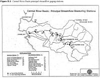
- This CCoWS map has gages marked on it: http://ccows.csumb.edu/pubs/maps/crwa/Poster/Carmel_Map1-2_36x44.pdf
- How to edit tables in MediaWiki
- Carmel Watershed
- Clickable map of USGS Surface Water Gages: http://waterdata.usgs.gov/nwis/rt
- Coordinates on USGS web sites are probably not as accurate as coordinates you can get from Google Earth.
- To get coordinates from Google Earth, find the gage, and create a Placemark. The coordinates will be displayed. To get them in a different projection, go to Tools --> Options
- Gages in Monterey are consolidated on this website: http://waterdata.usgs.gov/ca/nwis/current?huc_cd=18060004&huc_cd=18060005&huc_cd=18060006&huc_cd=18060011&huc_cd=18060012&index_pmcode_STATION_NM=1&index_pmcode_DATETIME=2&index_pmcode_00065=3&index_pmcode_00060=4&index_pmcode_MEAN=&index_pmcode_MEDIAN=&index_pmc [1]
- Calculator for converting Lat/Lon coordinates to UTM WGS84 Easting and Northing coordinates: http://www.uwgb.edu/dutchs/UsefulData/HowUseExcel.HTM
- On the web page click the "Spreadsheet For UTM Conversions" link.
- Go tho the "Main Page" tab and enter your information.
- It would be great if someone could check its accuracy.

Disclaimer
This page may contain students' work completed as part of assigned coursework. It may not be accurate. It does not necessarily reflect the opinion or policy of CSUMB, its staff, or students.