Difference between revisions of "Carmel River Floodplain Restoration and Environmental Enhancement (Carmel River FREE) Project"
(→Summary) |
|||
| Line 9: | Line 9: | ||
* Replace 360 ft of the Highway 1 roadway with an elevated causeway to allow floodwater movement under the highway and connect the floodplain to the Carmel River Lagoon, | * Replace 360 ft of the Highway 1 roadway with an elevated causeway to allow floodwater movement under the highway and connect the floodplain to the Carmel River Lagoon, | ||
| − | * 100 acres of historic floodplain | + | * 100 acres of agricultural land graded to mimic the historic floodplain including braided off-stream channels and depressions for sediment settlement, |
* 90 acres of riparian and grassland habitat restoration and monitoring, | * 90 acres of riparian and grassland habitat restoration and monitoring, | ||
| Line 19: | Line 19: | ||
== Location == | == Location == | ||
| − | Carmel River FREE will restore floodplain in the Lower [[Carmel Watershed]] in Carmel Valley, Monterey County, California. The project site is east of the Highway 1 bridge over the Carmel River. | + | Carmel River FREE will restore floodplain in the Lower [[Carmel Watershed]] in Carmel Valley, Monterey County, California. The project site is east of the Highway 1 bridge over the Carmel River. |
==Background== | ==Background== | ||
| − | |||
| − | |||
In 2010 BSLT proposed alleviating the risk of flooding in the Lower Carmel Valley by restoring the floodplain instead of expensive levee reinforcements. <ref>[http://www.montereycountyweekly.com/news/local_news/carmel-river-free-project-hopes-to-relegate-flooding-to-history/article_604313b0-9ec2-11e5-aa09-17669b94a858.html Carmel River FREE Project hopes to relegate flooding to history, Monterey County NOW]</ref> | In 2010 BSLT proposed alleviating the risk of flooding in the Lower Carmel Valley by restoring the floodplain instead of expensive levee reinforcements. <ref>[http://www.montereycountyweekly.com/news/local_news/carmel-river-free-project-hopes-to-relegate-flooding-to-history/article_604313b0-9ec2-11e5-aa09-17669b94a858.html Carmel River FREE Project hopes to relegate flooding to history, Monterey County NOW]</ref> | ||
| − | == | + | == Objectives == |
| − | + | ||
| − | + | =Floodplain and habitat restoration= | |
| − | + | In addition to restoring 100 acres of floodplain, riparian, and grassland habitat, Carmel River FREE will connect a 1997 Caltrans restoration site to the west of Highway 1 with the [[Carmel River Lagoon Enhancement Project]] (completed in 2004 by California State Parks). Together, these projects create a wildlife corridor along the [[Carmel River]] and maintain important habitat for migratory birds, protected California red-legged frogs and Steelhead, and state-listed Western pond turtles. | |
| − | + | =Groundwater recharge= | |
| − | + | =Improved water quality= | |
| − | + | =Reduced flood risk= | |
CSA-50 includes the Crossroads shopping center and private residences in the Riverwood, Arroyo Carmel, and Mission Fields communities. The area is within the [[100-year floodplain]] limits of the [[Carmel River]] North Overbank; CSA-50 has 69 [[Repetitive Loss Properties]], 63% of such properties in Monterey County. <ref name ="CSA 50 Flood Report"/> Flooding in 1995 damaged 220 residences in CSA-50 and destroyed the Highway 1 bridge. | CSA-50 includes the Crossroads shopping center and private residences in the Riverwood, Arroyo Carmel, and Mission Fields communities. The area is within the [[100-year floodplain]] limits of the [[Carmel River]] North Overbank; CSA-50 has 69 [[Repetitive Loss Properties]], 63% of such properties in Monterey County. <ref name ="CSA 50 Flood Report"/> Flooding in 1995 damaged 220 residences in CSA-50 and destroyed the Highway 1 bridge. | ||
| − | ''' | + | '''Public access''' |
| + | |||
| + | Carmel River FREE includes plans for recreational trails that will connect [http://www.parks.ca.gov/?page_id=567 Carmel River State Beach] with [http://www.mprpd.org/palo-corona-regional-park/ Palo Corona Regional Park]. | ||
| + | |||
| + | == Funding == | ||
| + | The [[Big Sur Land Trust]] secured $14 million in grant funds from the California Water Resources Agency, US Environmental Protection Agency, US Fish and Wildlife Service, [[California Coastal Conservancy]], and the California Wildlife Conservation Board. <ref name = "BSLT newsletter"/> | ||
| + | |||
| + | The 2014 Monterey County Service Area 50 Flood Control Report <ref name = "CSA 50 Flood Report">[https://www.google.com/url?sa=t&rct=j&q=&esrc=s&source=web&cd=1&ved=0ahUKEwib3eauie_LAhVPxGMKHchnDy4QFggcMAA&url=http%3A%2F%2Fwww.co.monterey.ca.us%2Fplanning%2Fmajor%2FEPB%2520and%2520Scenic%2520Road%2520Protection%2FCSA-50_Lower_Carmel_River_Flood_Control_Study%2FCSA-50_FLOOD_CONTROL_REPORT_FINAL_103114.pdf&usg=AFQjCNE0Vhnm5jfxSZyXkmwfJkgsYCqQxg&sig2=MKnQz7Fj4NiMKWNH12l88w&bvm=bv.118443451,d.cGc&cad=rja CSA-50 Final Lower Carmel River Stormwater Management and Flood Control Report]</ref> estimated that the Carmel River FREE project would reduce the cost of flood control improvements from $25,771,000 to $11,322,000. | ||
== Agencies Involved == | == Agencies Involved == | ||
Revision as of 21:36, 6 April 2016
A watershed-related issue examined by the ENVS 560/L Watershed Systems class at CSUMB.

Contents
Summary
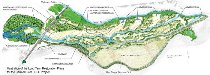
The Carmel River Floodplain Restoration and Environmental Enhancement Project (Carmel River FREE) is a collaboration between the Big Sur Land Trust (BSLT) and the County of Monterey Resource Management Agency to reduce the flood risk for businesses and residences in the Lower Carmel Valley and restore the active floodplain. The project encompasses the following components: [1] [2]
- Removal of 1,470 ft of levee on the south side of the Carmel River to allow river access to the Odello East floodplain,
- Replace 360 ft of the Highway 1 roadway with an elevated causeway to allow floodwater movement under the highway and connect the floodplain to the Carmel River Lagoon,
- 100 acres of agricultural land graded to mimic the historic floodplain including braided off-stream channels and depressions for sediment settlement,
- 90 acres of riparian and grassland habitat restoration and monitoring,
- 23 acres reserved for organic agriculture, elevated above the 100-year floodplain.
Construction is projected to begin in early 2018 and be completed within a year. [3]
Location
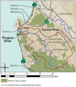
Carmel River FREE will restore floodplain in the Lower Carmel Watershed in Carmel Valley, Monterey County, California. The project site is east of the Highway 1 bridge over the Carmel River.
Background
In 2010 BSLT proposed alleviating the risk of flooding in the Lower Carmel Valley by restoring the floodplain instead of expensive levee reinforcements. [4]
Objectives
Floodplain and habitat restoration
In addition to restoring 100 acres of floodplain, riparian, and grassland habitat, Carmel River FREE will connect a 1997 Caltrans restoration site to the west of Highway 1 with the Carmel River Lagoon Enhancement Project (completed in 2004 by California State Parks). Together, these projects create a wildlife corridor along the Carmel River and maintain important habitat for migratory birds, protected California red-legged frogs and Steelhead, and state-listed Western pond turtles.
Groundwater recharge
Improved water quality
Reduced flood risk
CSA-50 includes the Crossroads shopping center and private residences in the Riverwood, Arroyo Carmel, and Mission Fields communities. The area is within the 100-year floodplain limits of the Carmel River North Overbank; CSA-50 has 69 Repetitive Loss Properties, 63% of such properties in Monterey County. [5] Flooding in 1995 damaged 220 residences in CSA-50 and destroyed the Highway 1 bridge.
Public access
Carmel River FREE includes plans for recreational trails that will connect Carmel River State Beach with Palo Corona Regional Park.
Funding
The Big Sur Land Trust secured $14 million in grant funds from the California Water Resources Agency, US Environmental Protection Agency, US Fish and Wildlife Service, California Coastal Conservancy, and the California Wildlife Conservation Board. [3]
The 2014 Monterey County Service Area 50 Flood Control Report [5] estimated that the Carmel River FREE project would reduce the cost of flood control improvements from $25,771,000 to $11,322,000.
Agencies Involved
Monterey County Water Resources Agency
Monterey Peninsula Water Management District
California Department of Parks and Recreation
Links
References
- ↑ Carmel River FREE, BLST blog
- ↑ Carmel River FREE handout, BSLT
- ↑ Carmel River FREE Project hopes to relegate flooding to history, Monterey County NOW
- ↑ 5.0 5.1 CSA-50 Final Lower Carmel River Stormwater Management and Flood Control Report
Disclaimer
This page may contain student work completed as part of assigned coursework. It may not be accurate. It does not necessary reflect the opinion or policy of CSUMB, its staff, or students.