Difference between revisions of "Carmel River Lagoon"
From CCoWS Wiki
Elizabethg (Talk | contribs) (→Gages) |
Elizabethg (Talk | contribs) |
||
| Line 1: | Line 1: | ||
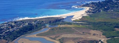
[[Image:CarmelRiverLagoon.jpg|500px|thumb|right|Carmel River Lagoon. Image: [http://www.esassoc.com/projects/carmel-river-lagoon-enhancement-project ESA]]] | [[Image:CarmelRiverLagoon.jpg|500px|thumb|right|Carmel River Lagoon. Image: [http://www.esassoc.com/projects/carmel-river-lagoon-enhancement-project ESA]]] | ||
The Carmel River Lagoon is located on the Central Coast of California, at the end of the 255 square mile [[The Carmel River Watershed| Carmel River Watershed]] <ref> [http://www.parks.ca.gov/?page_id=25124 California State Parks] </ref>. During high flows the sand bar at Carmel River State Beach is breached and the lagoon empties into Carmel Bay, part of the federally protected [[Monterey Bay National Marine Sanctuary]] <ref> [https://docs.google.com/viewer?a=v&q=cache:ZPYn8vefPBkJ:www.mpwmd.dst.ca.us/mbay_irwm/irwm_library/LCR/LCRproject.pdf+&hl=en&gl=us&pid=bl&srcid=ADGEESjpq-iWrwDt0TOQmdzsJhr7-GHoyxFrL97CzTfNGAeKuGP6QmP_Ku3I7OKFR8MwJ-ooXOb0MuJ0q72hx6k7b8PSy9V6OCF9fpRv9tU93bgLjkSQCg81aoQHQ6HfswUq2ndgJ3ug&sig=AHIEtbSbEkR8EKjZas2AM0_AL7uzWd-yFg Lower Carmel River and Lagoon Floodplain Restoration Project] </ref>. | The Carmel River Lagoon is located on the Central Coast of California, at the end of the 255 square mile [[The Carmel River Watershed| Carmel River Watershed]] <ref> [http://www.parks.ca.gov/?page_id=25124 California State Parks] </ref>. During high flows the sand bar at Carmel River State Beach is breached and the lagoon empties into Carmel Bay, part of the federally protected [[Monterey Bay National Marine Sanctuary]] <ref> [https://docs.google.com/viewer?a=v&q=cache:ZPYn8vefPBkJ:www.mpwmd.dst.ca.us/mbay_irwm/irwm_library/LCR/LCRproject.pdf+&hl=en&gl=us&pid=bl&srcid=ADGEESjpq-iWrwDt0TOQmdzsJhr7-GHoyxFrL97CzTfNGAeKuGP6QmP_Ku3I7OKFR8MwJ-ooXOb0MuJ0q72hx6k7b8PSy9V6OCF9fpRv9tU93bgLjkSQCg81aoQHQ6HfswUq2ndgJ3ug&sig=AHIEtbSbEkR8EKjZas2AM0_AL7uzWd-yFg Lower Carmel River and Lagoon Floodplain Restoration Project] </ref>. | ||
| + | |||
| + | == Reports == | ||
| + | The California Coast Watershed Studies Team (CCoWS) has produced several reports on the Carmel River Lagoon: | ||
| + | * [http://ccows.csumb.edu/pubs/reports/CCoWS_LagoonBreaching2001_010403.pdf Winter Water Quality of the Carmel and Salinas Lagoons, Monterey, California: 2000/2001] | ||
| + | * [http://ccows.csumb.edu/pubs/reports/CCoWS_LagoonBreaching2001-2002_020923B.pdf Hydrology and Water Quality of the Carmel and Salinas Lagoons Monterey Bay, California 2001/2002] | ||
| + | * 2002-3 report to MCWRA | ||
| + | * 2004 report to Cal-Am | ||
| + | * 2004 report on habitat types | ||
| + | * 2004 report to State Parks | ||
| + | * 2004-5 report to State Parks | ||
| + | * 2005-6 report to State Parks | ||
| + | * 2006-7 report to State Parks | ||
| + | * 2006 report to CDFG and Garrapata WC | ||
| + | * 2007 thesis on invertebrates | ||
| + | * 2007 report by CSUMB class | ||
| + | * 2008 report by CSUMB class | ||
| + | * 2009 report by CSUMB class | ||
| + | * 2010 thesis on invertebrates | ||
== Gages == | == Gages == | ||
Revision as of 23:49, 9 April 2013

Carmel River Lagoon. Image: ESA
The Carmel River Lagoon is located on the Central Coast of California, at the end of the 255 square mile Carmel River Watershed [1]. During high flows the sand bar at Carmel River State Beach is breached and the lagoon empties into Carmel Bay, part of the federally protected Monterey Bay National Marine Sanctuary [2].
Contents
Reports
The California Coast Watershed Studies Team (CCoWS) has produced several reports on the Carmel River Lagoon:
- Winter Water Quality of the Carmel and Salinas Lagoons, Monterey, California: 2000/2001
- Hydrology and Water Quality of the Carmel and Salinas Lagoons Monterey Bay, California 2001/2002
- 2002-3 report to MCWRA
- 2004 report to Cal-Am
- 2004 report on habitat types
- 2004 report to State Parks
- 2004-5 report to State Parks
- 2005-6 report to State Parks
- 2006-7 report to State Parks
- 2006 report to CDFG and Garrapata WC
- 2007 thesis on invertebrates
- 2007 report by CSUMB class
- 2008 report by CSUMB class
- 2009 report by CSUMB class
- 2010 thesis on invertebrates
Gages
- The lagoon stage in feet is listed on this page
References
Links
- The Carmel River Watershed
- MPWMD TM 05-01 by Greg James
- RMC consulting bathymetric & topographic survey report
- Maps of the Carmel River Watershed
Disclaimer
This page may contain student work completed as part of assigned coursework. It may not be accurate. It does not necessary reflect the opinion or policy of CSUMB, its staff, or students.