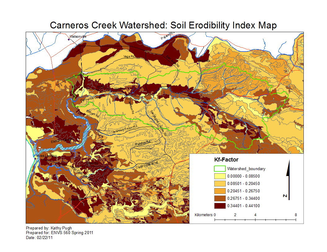
Carneros Watershed: Map of Soil Erodibility Index
From CCoWS Wiki

Metadata
- Original source of data: SSURGO
- Data analysis: Fred Watson and Kathy Pugh
- Map produced by: Kathy Pugh
- Map produced using: ArcMap
- Coordinate system: Geographic Coordinate System - GCS_North_American_1983
- Datum: D_North_American_1983
Data Analysis Steps Taken
- 1. Download SSURGO data
- 2. Receive zip file of zip files, each one like soil_ca069.zip.
- 3. Extract, and open basic shapefile of map-units (MU): soilmu_a_ca069.shp in Arc
- 4. Can't read tables in this zip, because need special MS Access Template
- 5. Download Access template from http://soildatamart.nrcs.usda.gov/templates.aspx
- 6. Open template in Access; Enable Macros; and it should prompt for location of your tables
- 7. Wait a few minutes while Access imports your tables
- 8. Create some custom queries in Access to extract some kind of Kf for each map unit
- 8a. Review the SSURGO data model: http://soildatamart.nrcs.usda.gov/documents/SSURGO_2_2_DataModel_Part_1.pdf
- 8b. Each MapUnit contains several Components, each containing several Horizons.
- 8c. First query selects the surface horizons:
- 8c1 - it joins tables muaggatt+component+chorizon,
- 8c2 - joining on keys mukey and cokey
- 8c3 - selecting only horizons whose hzdept_r is 0 (i.e. surface horizons)
- 8c4 - includes the kffact (Kf-factor) and comppct_r (Percentage of map-unit occupied by Component) fields that will be used below
- 8d. Second query takes first as input, and is a MakeTable query, making the table that will be used in Arc
- 8d1 - computes an expression 'yournamekf: Sum([comppct_r]*[kffact]/100)'
- 8d2 - it is a Summation query, and the Summation is done on the fredkf field (above)
- 8d3 - the other two fields are musym and mukey, and they are GroupBy fields
- 8e. RUn the second query; it will make a table
- 8f. Export the table to DBF format (one way of getting it to Arc)
- 9. Back in Arc, add the DBF table as a layer
- 10. Join the soilmu_a_ca069.shp layer to the DBF layer, using the mukey
- 11. Change the soilmu_a_ca069.shp symbology to display quantitative based on the yournamekf field
Alternate versions
- None