Difference between revisions of "File:CarnerosWatershed Landcover.png"
From CCoWS Wiki
| Line 1: | Line 1: | ||
| + | [[Image:CarnerosWatershed_LandCover.png|200px|thumb|Carneros Watershed: Land Cover]] | ||
| + | * [[Media:CarnerosWatershed_LandCover.pdf|PDF file - for printing]] | ||
| + | * [[Media:CarnerosWatershed_LandCover.png|PNG file]] | ||
| + | |||
| + | == Metadata == | ||
| + | |||
| + | * Original source of data: | ||
| + | ** Hydrography: [[National Map]] hydrography data set | ||
| + | ** Roads: [[National Map]] transportation data set | ||
| + | ** Watershed boundary: Watershed analysis in ArcMap by [[Fred Watson]] based on [[National Map]] 1/3 arc-second elevation data | ||
| + | * Data analysis: [[Fred Watson]] (watershed boundary) | ||
| + | * Base Map produced by: Rose Ashbach | ||
| + | * Land Cover Map produced by: Michele Lanctot | ||
| + | * Map produced using: [[ArcMap]] | ||
| + | * Coordinate system: Geographic Coordinate System - GCS_North_American_1983 | ||
| + | * Datum: D_North_American_1983 | ||
| + | |||
| + | == Alternate versions == | ||
| + | |||
| + | * None | ||
| + | |||
| + | == Links == | ||
| + | |||
| + | * [[Maps of the Carneros Watershed]] | ||
| + | * [[How to Post a Map on the Wiki]] | ||
Revision as of 08:31, 12 February 2011
File:CarnerosWatershed LandCover.png
Carneros Watershed: Land Cover
Metadata
- Original source of data:
- Hydrography: National Map hydrography data set
- Roads: National Map transportation data set
- Watershed boundary: Watershed analysis in ArcMap by Fred Watson based on National Map 1/3 arc-second elevation data
- Data analysis: Fred Watson (watershed boundary)
- Base Map produced by: Rose Ashbach
- Land Cover Map produced by: Michele Lanctot
- Map produced using: ArcMap
- Coordinate system: Geographic Coordinate System - GCS_North_American_1983
- Datum: D_North_American_1983
Alternate versions
- None
Links
File history
Click on a date/time to view the file as it appeared at that time.
| Date/Time | Thumbnail | Dimensions | User | Comment | |
|---|---|---|---|---|---|
| current | 08:19, 12 February 2011 | 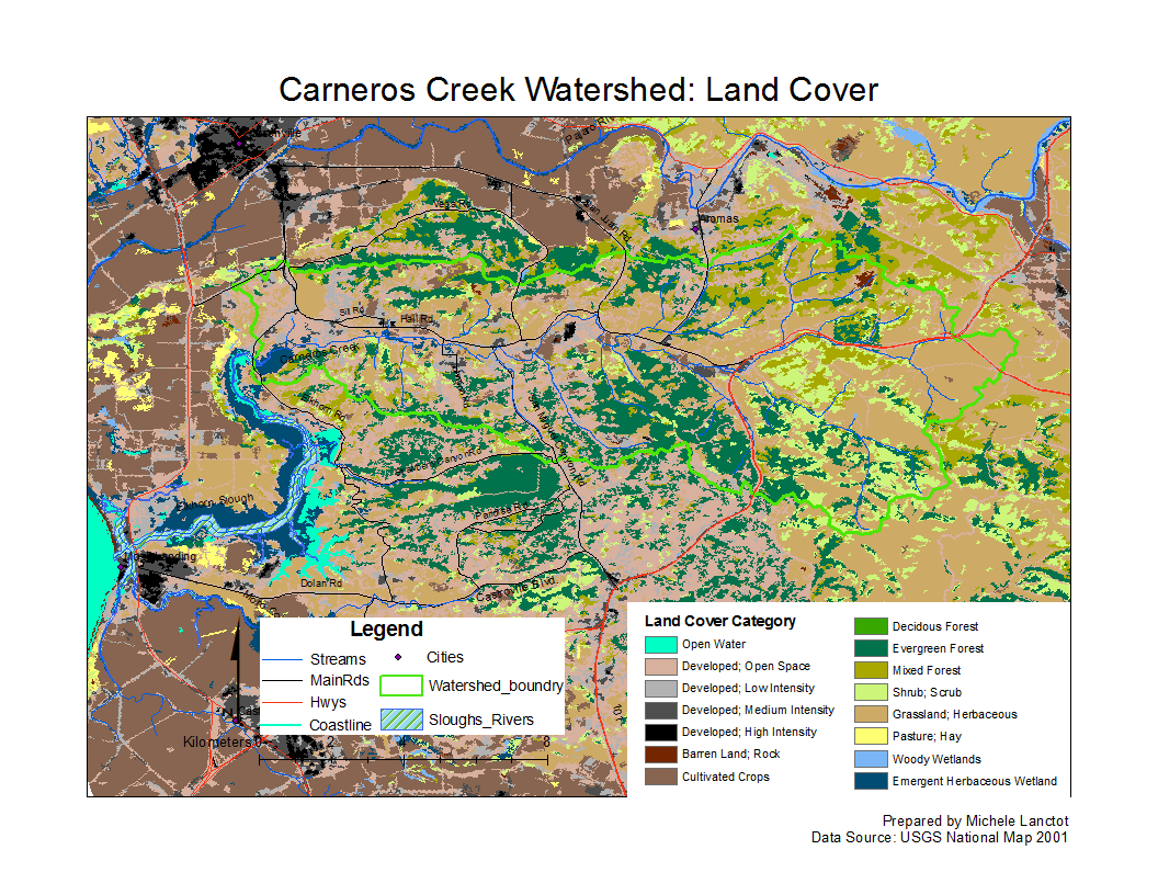 | 1,056 × 816 (224 KB) | Gabrielaa (Talk | contribs) |
- You cannot overwrite this file.
File usage
The following 3 pages link to this file: