Difference between revisions of "Fort Ord"
(→Fort Ord National Monument) |
(→Habitat) |
||
| Line 20: | Line 20: | ||
==Habitat== | ==Habitat== | ||
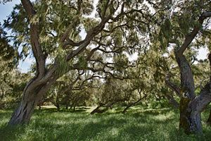
| − | [[Image:Fortordoak.jpg|300px|thumb|right|Oak woodland habitat on Fort Ord lands.]]Fort Ord lands are mainly comprised of maritime chaparral | + | [[Image:Fortordoak.jpg|300px|thumb|right|Oak woodland habitat on Fort Ord lands.]]Fort Ord lands are mainly comprised of maritime chaparral, oak woodlands, and grasslands. These habitats offer ecological, economic, and aesthetic values to the area. Fort Ord lands have the largest remaining areas of maritime chaparral on the coast <ref> [http://www.fortordcleanup.com/ar_pdfs/ar-bw-2450d/bw-2450d_text.pdf. Habitat Management Plan] </ref>. According to the Fort Ord Reuse Plan, the City of Marina must make [[Oak Woodland Protection Plans]] to conserve Coast live oaks on former Fort Ord lands. |
== Land Management== | == Land Management== | ||
Revision as of 23:20, 1 April 2013
This page gives a short history of Fort Ord and a description of the current state of the former Fort Ord lands and entities involved with the land's redistribution.
Contents
History
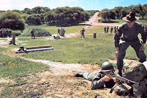
The former Fort Ord, located just north of Monterey Bay in Monterey County, began as Gigling Reservation, an artillery-training field for the Army in 1917. By the beginning of World War II, it had expanded by 2,000 acres and was renamed from Camp Ord to Fort Ord. The fort served as the Army’s primary facility for basic training and staging for the next thirty years. In 1988, Congress passed the Base Realignment and Closure (BRAC) legislation, and by 1994 the largest U.S. military base at the time was officially closed, transferring ~ 28,000 acres (~ 45 square miles) to a conglomeration of government entities and local organizations, including the cities of Seaside, Del Rey Oak, Marina, Monterey County, University of California Santa Cruz (UCSC), California State University Monterey Bay (CSUMB), the U.S. Army and the Bureau of Land Management (BLM) (FORA 2012).Timeline
- 1990 Fort Ord is placed on EPA's Superfund List.
- 1991 Fort Ord placed on the Base Reuse and Closure List.
- 1993 Munitions archival investigations begin.
- 1994 Fort Ord is formally closed. CSU Monterey Bay is create by initial land transfer. FORA created by California State law.
- 1995 CSUMB opens with 3,000 students.
- 1997 Fort Ord Base Reuse Plan approved. Coastal Dunes cleanup begins.
- 2000 Coastal Dunes remedial activities and revegetation completed.
- 2002 Landfill consolidation and placement of cap completed.
- 2004 Army/FORA initiated ESCA discussions.
- 2004-2007 FORA reports regularly.
- 2005-2006 Formal ESCA negotiations.
- 2007 Army and FORA execute ESCA.
- FORA ESCA Remediation Program established.
Habitat
Fort Ord lands are mainly comprised of maritime chaparral, oak woodlands, and grasslands. These habitats offer ecological, economic, and aesthetic values to the area. Fort Ord lands have the largest remaining areas of maritime chaparral on the coast [1]. According to the Fort Ord Reuse Plan, the City of Marina must make Oak Woodland Protection Plans to conserve Coast live oaks on former Fort Ord lands.Land Management
FORA works with 67 different agencies at all government levels in order to transfer land to the proper local jurisdictions [2]
- Fort Ord Reuse Authority (FORA)
- Base Realignment and Closure (BRAC)
Fort Ord National Monument
In April of 2012, President Obama proclaimed a 15,000 acre portion of the former Fort Ord a National Monument.The monument consists of the approximate 8,000 acres currently managed by the Bureau of Land Management (BLM), and the approximate 7,000 acres currently managed by the Army which are set to be transferred to the BLM pending military ordnance cleanup . The Fort Ord National Monument (FONM) has over 86 miles of trails through portions of the last undeveloped wilderness on the peninsula [3]. Hiking, mountain biking, and horseback riding are a few of the common visitor activities.
CSUMB Courses relevant to Fort Ord
- BIO 340/L Ecology
- Chaparral field trip
- S:ENVS 436/536/L Remote Sensing and Image Processing
- Remotely sensed map of Fort Ord land cover
CSUMB people working on Fort Ord
- Suzy Worcecster
- Fred Watson
- Bart Kowalski
- Aimee Teaby
- See also: Fort Ord Workgroup
References
Links
Disclaimer
This page may contain student work completed as part of assigned coursework. It may not be accurate. It does not necessary reflect the opinion or policy of [CSUMB], its staff, or students.

