Fort Ord
An environmental summary created by the ENVS 560/L Watershed Systems class at CSUMB.
This page gives a short history of the former Fort Ord and a description of the current state of the former Fort Ord lands.Contents
History
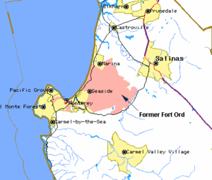
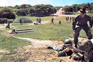
The former Fort Ord, located just north of Monterey Bay in Monterey County, began as Gigling Reservation, an artillery-training field for the Army in 1917. By the beginning of World War II, it had expanded by 2,000 acres and was renamed from Camp Ord to Fort Ord. The fort served as the Army’s primary facility for basic training and staging for the next thirty years. During the 50s and 60s, the Fort was used to prep units departing for war. In ’76 basic training was stopped on the Ord and it became the base for the 7th Infantry Battalion. In 1988, Congress passed the Base Realignment and Closure (BRAC) legislation, and by 1994 the largest U.S. military base at the time was officially closed, transferring ~ 28,000 acres (~ 45 square miles) to a conglomeration of government entities and local organizations, including the cities of Seaside, Del Rey Oak, Marina, Monterey County, University of California Santa Cruz (UCSC), California State University Monterey Bay (CSUMB), the U.S. Army and the Bureau of Land Management (BLM) [1] .
Timeline
<Need links to actual docs. Several of these are given on the HCP page.>
- 1917 Fort Ord established as a maneuver area and field artillery target range.
- 19 ......
- 1990 Fort Ord is placed on EPA's Superfund List.
- 1991 Fort Ord placed on the Base Reuse and Closure List.
- 1992 Fort Ord Reuse Group (FORG) organized by local governments plans next steps for base closure and reuse.
- 1993 Initial reuse plan is approved by FORG.
- Army issues its Environmental Impact Statement.
- Senator Henry Mello proposes legislation (Senate Bill 899) to create the Fort Ord Reuse Authority (FORA).
- Munitions archival investigations begin.
- 1994 Fort Ord is formally closed.
- Properties transferred to University of California and California State University under special Economic Development Conveyance (EDC) legislation. CSU Monterey Bay is created by this initial land transfer.
- FORA created by California State law.
- Initial Habitat Management Plan (HMP) published.
- 1995 CSUMB opens with 3,000 students.
- FORA commences infrastructure design and construction.
- 1997 Fort Ord Base Reuse Plan approved.
- Revised HMP published.
- Coastal Dunes cleanup begins.
- FORA submits EDC application to the U.S. Army.
- 1998 FORA/Army negotiations commence on the EDC.
- 1999 President Clinton signs a "No-Cost" EDC legislation allowing property transfers to FORA for job creation.
- EDC negotiations concluded.
- 2000 Army/FORA memorandum of agreement (MOA) completed, allowing for the transfer of 5,300 acres under the EDC.
- First properties transferred under the EDC.
- Coastal Dunes remedial activities and revegetation completed.
- 2001 Fort Ord Reuse Plan and Environmental Impact Report (EIR) consolidated and republished.
- 2002 Landfill consolidation and placement of cap completed.
- 2004 Army/FORA initiated ESCA discussions.
- 2004-2007 FORA reports regularly.
- 2005-2006 Formal ESCA negotiations.
- 2007 Army and FORA execute ESCA.
- FORA-ESCA Remediation Program established.
Habitat
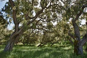
Fort Ord lands are mainly comprised of maritime chaparral, oak woodlands, and grasslands. These habitats offer ecological, economic, and aesthetic values to the area. Fort Ord lands have the largest remaining areas of maritime chaparral on the coast [2]. According to the Fort Ord Reuse Plan, the City of Marina must make Oak Woodland Protection Plans to conserve Coast live oaks on former Fort Ord lands.Land Management
BRAC and FORA
After the Base Realignment and Closure (BRAC) recommended closing the fort, Fort Ord Reuse Authority (FORA) was established to manage the reuse and transfer of former Fort Ord Lands. FORA works with 67 different agencies at all government levels in order to transfer land to the proper local jurisdictions [3]. FORA’s Base Reuse Plan designates 25% of the former Fort Ord Lands for development to create jobs and housing and 75% of the lands for open space, recreational use, and habitat management.[4] There are several proposed developments on former Fort Ord lands. For a full list of proposed developments see the FORA page. Due the California Environmental Quality Act (CEQA), an Environmental Impact Report (EIR) on Fort Ord is required to assess the impact of any proposed developments on land, air, water, minerals, flora, fauna, noise, and objects of historic or aesthetic significance [5].
BRP
In 1997, the Fort Ord Base Reuse Plan (BRP) was prepared by FORA. The former base covers 28,000 acres of land. Approximately 18,000 acres were preserved as permanent open space under the jurisdictions of the Federal Bureau of Land Management and California Department of Parks and Recreation. The remaining 10,000 acres are now under the jurisdictions of Monterey County, the cities of Monterey, Seaside, Del Rey Oaks, and Marina, two universities, and the United States Army [6].
Protecting Fort Ord
Fort Ord National Monument
In April of 2012, President Obama proclaimed a 15,000 acre portion of the former Fort Ord a national monument [7] [8].The Fort Ord National Monument (FONM) consists of approximately 8,000 acres currently managed by the Bureau of Land Management (BLM), and approximately 7,000 acres currently managed by the Army which are set to be transferred to the BLM pending military ordnance cleanup. The FONM has over 86 miles of trails winding through portions of the last undeveloped wilderness on the Monterey Peninsula [9]. Hiking, mountain biking, and horseback riding are a few of the common recreational activities that are popular. Eco-recreation and heritage tourism are two of the many benefits preservation of the Fort Ord Public Lands will bring to Monterey County as a national monument. [10]
Local Support
California Congressional Delegation
Veterans
Community Groups and Organizations
- Monterey Off-Road Cycling Association (MORCA) a chapter of IMBA
- Bicycle Equestrian Trails Assistance (BETA)
- Big Sur Marathon
- Central Coast Cycling Club
- Citizens for Sustainable Marina
- Communities for Sustainable Monterey County
- Friends of the Fort Ord Warhorse
- Fort Ord Access Alliance
- Fort Ord Rec Users (forU)
- Fort Ord Recreation Trails Friends (FORT Friends)
- Keep Fort Ord Wild
- Monterey Bay Chapter of the Native Plant Society
- Monterey Coastkeeper
- Monterey County Search and Rescue Dogs, Inc.
- Marina Equestrian Center
- Protect Fort Ord
- Return of the Natives Restoration Education Project
- Sustainable Seaside
- Wednesday Night Laundry Runners
- Western States Draft and Driving Association
National Organizations
- REI - Recreational Equipment, Inc.
- Conservation Lands Foundation
- Environment America
- League of Conservation Voters
- National Trust for Historic Preservation
- Sea Otter Classic
- Sierra Club
- The Wilderness Society
References
- ↑ Fort Ord Base Reuse Plan
- ↑ Habitat Management Plan
- ↑ FORA
- ↑ Fort Ord Reuse Authority Summary
- ↑ CEQA Guidelines
- ↑ [1]
- ↑ President Proclamation -- Establishment of the Fort Ord National Monument
- ↑ Huet, Ellen. 2012 April 21. Fort Ord declared a national monument by Obama. San Francisco Chronicle
- ↑ BLM
- ↑ What's a National Monument?
Links
- Fort Ord Reuse Authority (FORA)
- Fort Ord Habitat Conservation Plan (HCP)
- Oak Woodland Protection Plans
- CEQA Overview
- SEP Focus Sites
- Special Status Species Within Fort Ord
Disclaimer
This page may contain student work completed as part of assigned coursework. It may not be accurate. It does not necessary reflect the opinion or policy of [CSUMB], its staff, or students.


