File list
From CCoWS Wiki
This special page shows all uploaded files.
| Date | Thumbnail | Size | User | Description | Versions | |
|---|---|---|---|---|---|---|
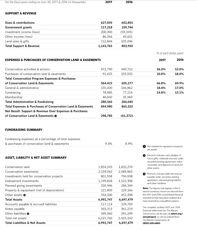
| 14:46, 10 April 2018 | TNC Financial.PNG (file) |  |
86 KB | RahilRyder | 1 | |
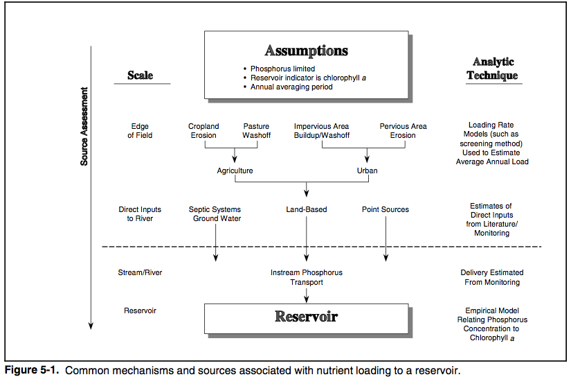
| 20:55, 21 April 2012 | TMDL source assessment.png (file) |  |
77 KB | Scottb | TMDL source assessment, from protocol document for developing nutrient TMDL standards | 1 |
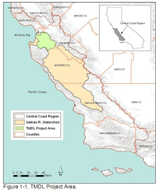
| 15:42, 21 March 2010 | TMDL project area.JPG (file) |  |
64 KB | Davidn | TMDL Fecal Coliform Salinas Project Area | 1 |
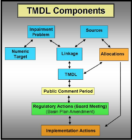
| 13:56, 4 April 2012 | TMDL development.jpeg (file) |  |
57 KB | Scottb | TMDL development chart figure 1-2 from [http://www.epa.gov/owow/tmdl/nutrient/pdf/nutrient.pdf] | 1 |
| 12:10, 9 April 2013 | TMDL SCCounty.JPG (file) |  |
56 KB | Ambers | 3 | |
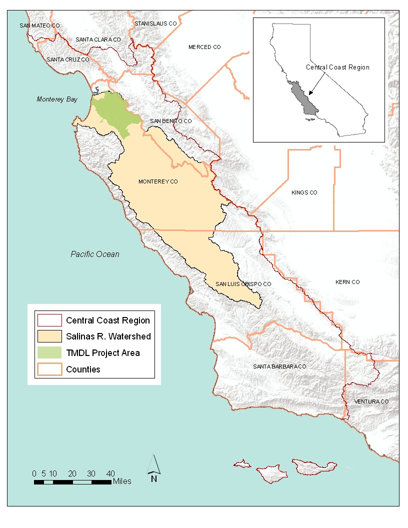
| 21:28, 31 March 2011 | TMDL Project Area.png (file) |  |
554 KB | Rosea | diazinon and chlorpyrifos TMDL project area | 1 |
| 01:31, 29 March 2012 | TMDL Impairment Map.png (file) |  |
574 KB | Scottb | TMDL nutrient impairment map for the Lower Salinas Valley Watershed. From CCWQRCB 2012 draft TMDL nutrient report) | 1 |
| 16:20, 12 April 2011 | TMDLGraphic.png (file) |  |
141 KB | Michelel | 1 | |
| 13:17, 29 March 2012 | TMDL2.jpg (file) |  |
230 KB | Cheriec | 1 | |
| 13:20, 29 March 2012 | TMDL.jpg (file) |  |
232 KB | Cheriec | 2 | |
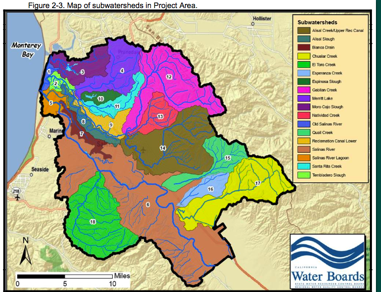
| 00:50, 29 March 2012 | Subwatersheds TMDL Nuts 2012.png (file) |  |
1.66 MB | Scottb | Subwatersheds identified in the preliminary draft report on TMDLs from the CCWQRCB (2012). Public agency=public domain | 1 |
| 00:52, 29 March 2012 | Subwatersheds TMDL Nuts 2012.jpeg (file) |  |
1.66 MB | Scottb | 1 | |
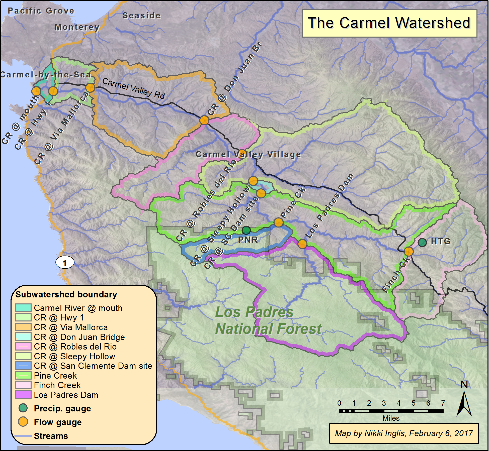
| 12:44, 30 March 2017 | Subwatersheds.png (file) |  |
3.65 MB | Nikkii | 1 | |
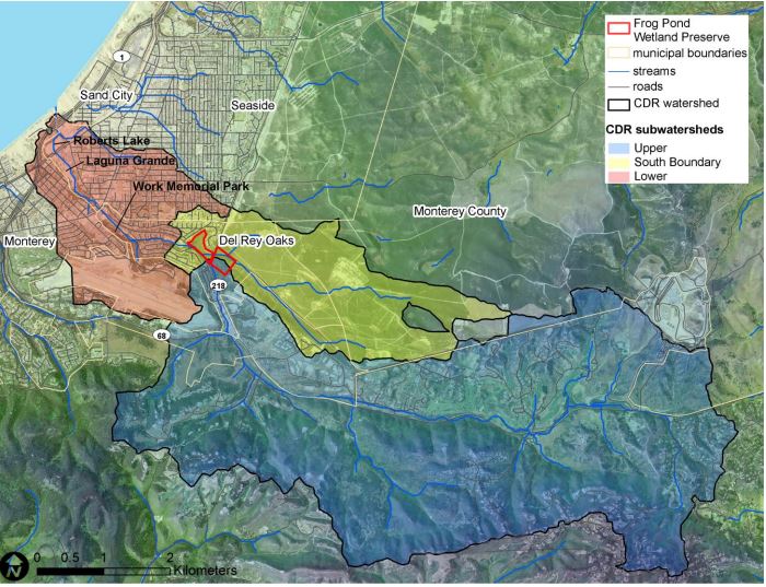
| 20:41, 6 April 2020 | SubwatershedCDR.JPG (file) |  |
109 KB | RyanB | 1 | |
| 10:59, 12 April 2012 | Stormwater.jpeg (file) |  |
291 KB | Cheriec | 1 | |
| 17:49, 2 April 2017 | Stocking trout.jpg (file) |  |
79 KB | Mattr | 1 | |
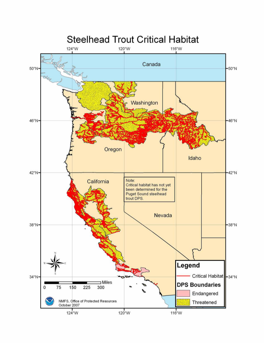
| 16:57, 25 March 2014 | Steelhead CritHab 2005.png (file) |  |
470 KB | Seann | NOAA steelhhead critical habitat map, 2005.http://www.nmfs.noaa.gov/pr/species/criticalhabitat.htm | 1 |
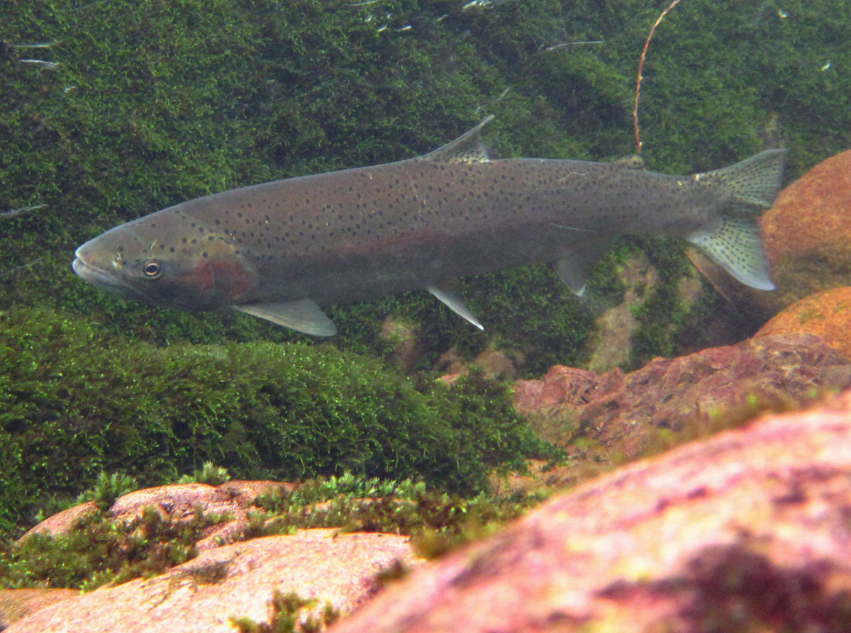
| 17:23, 29 March 2014 | Steelhead.jpg (file) |  |
1.31 MB | Seann | 1 | |
| 13:25, 14 April 2016 | Stateconservancies.PNG (file) |  |
65 KB | Stevef | Photo Taken from the California Legislative Analyst Office Report From: http://www.lao.ca.gov/reports/2015/budget/water-bond/water-bond-021115.aspx | 1 |
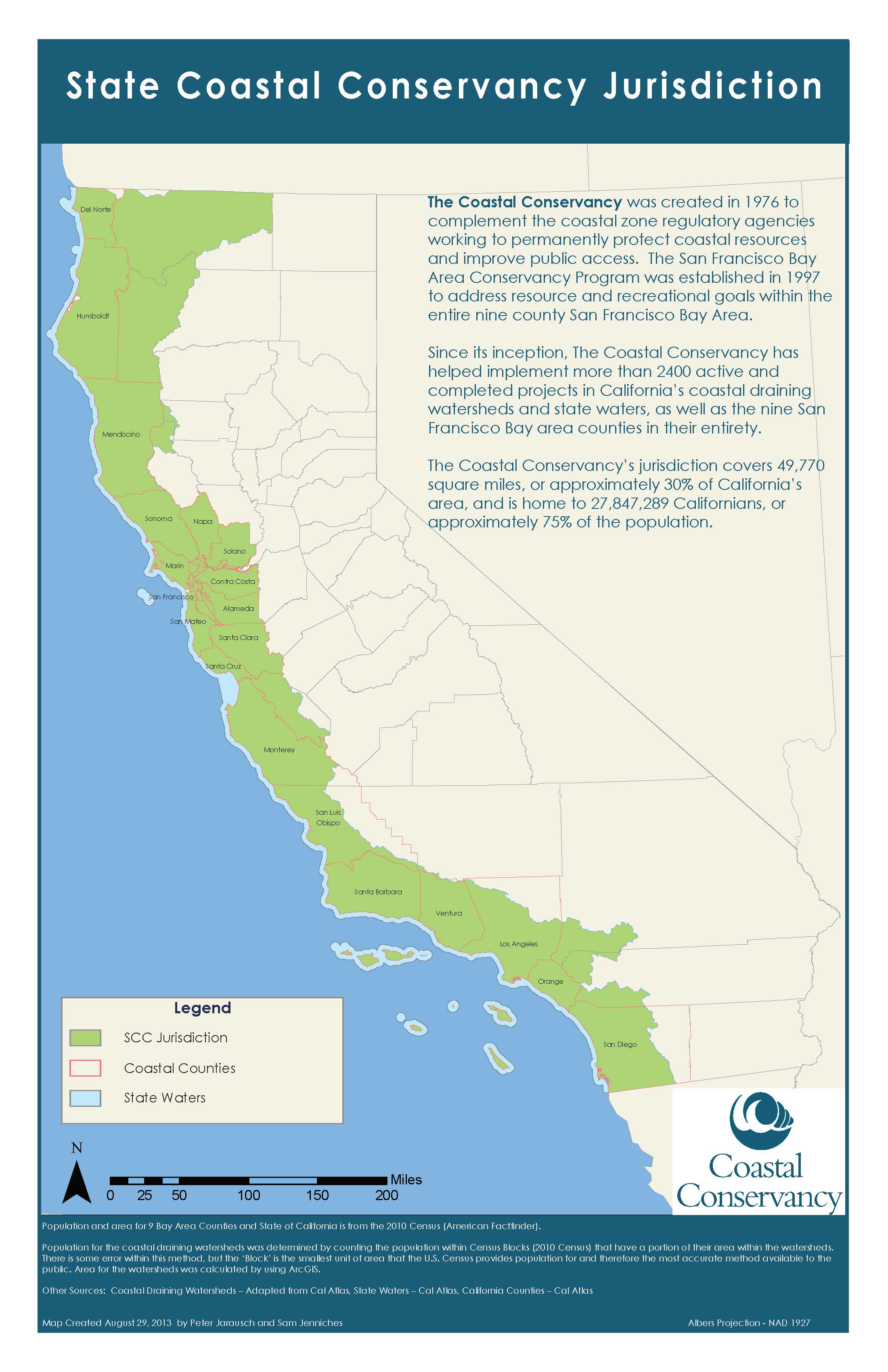
| 16:16, 31 March 2018 | StateCoastalConservancyJurisdiction.jpg (file) |  |
482 KB | JesseDoyle | State Coastal Conservancy Jurisdiction as provided by the Coastal Conservancy Website as of 2018. | 1 |
| 13:11, 2 April 2014 | Species list.xlsx (file) | 7 KB | Johni | Sources: US Fish and Wildlife | 1 | |
| 19:43, 4 February 2010 | Spatial poster presentation.pdf (file) | 436 KB | Mariao | Reverted to version as of 02:24, 5 February 2010 | 4 | |
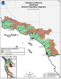
| 09:42, 8 April 2020 | SouthernCalCoastSteelhead noaa.png (file) |  |
1.09 MB | BryanVO | 1 | |
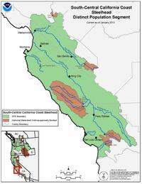
| 11:54, 8 April 2020 | SouthcentralCalcoast steelhead.jpg (file) |  |
14 KB | BryanVO | 1 | |
| 11:04, 12 April 2018 | South Boundary Biological Monitoring.pdf (file) | 79 KB | CorySteinmetz | Burleson Consulting 2008. South Boundary Road Biological Monitoring Report | 1 | |
| 12:13, 8 April 2020 | SouthCentralCaliforniaCoastSteelhead.jpg (file) |  |
14 KB | BryanVO | 1 | |
| 08:24, 3 February 2009 | Soil type5.png (file) |  |
1 KB | Pamk | 1 | |
| 08:27, 3 February 2009 | Soil type3.png (file) |  |
2 KB | Pamk | 1 | |
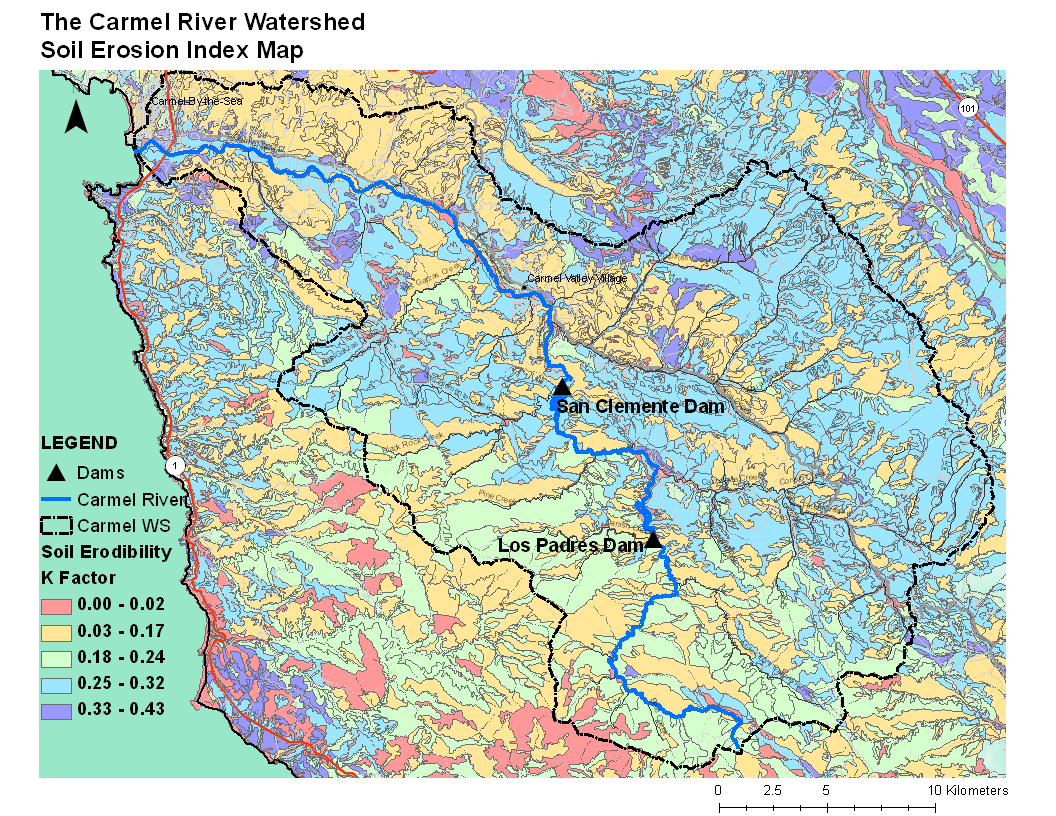
| 16:56, 11 February 2010 | Soil erosion index2.png (file) |  |
297 KB | Sandyc | 1 | |
| 17:02, 11 February 2010 | Soil erosion index2.pdf (file) | 5.09 MB | Sandyc | 1 | ||
| 16:58, 11 February 2010 | Soil erosion index.png (file) |  |
297 KB | Sandyc | 2 | |
| 20:00, 4 February 2009 | Soil erosion index.pdf (file) | 1.9 MB | Steveq | 1 | ||
| 19:57, 4 February 2009 | Soil erosion QUAN LRES.pdf (file) | 1.9 MB | Steveq | 1 | ||
| 17:00, 11 February 2010 | Soil Erosion Index2.png (file) |  |
297 KB | Sandyc | 2 | |
| 16:59, 11 February 2010 | Soil Erosion Index2.pdf (file) | 5.09 MB | Sandyc | 1 | ||
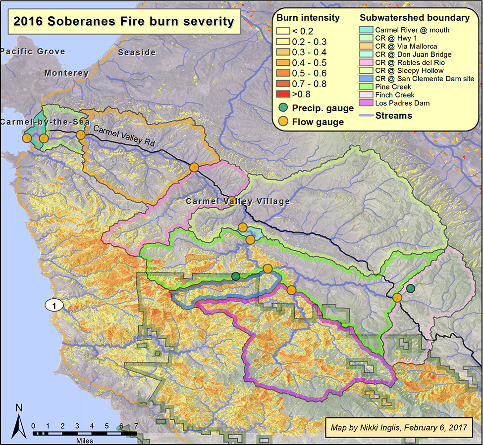
| 17:52, 28 March 2017 | Soberanes burn severity2016.png (file) |  |
1.67 MB | Nikkii | Difference in normalized burn ratio before and after the Soberanes Fire. Measurements were taken on June 20, 2016 and Oct. 27, 2017 using Landsat imagery.. Projection: WGS 1984 UTM Zone 10N | 1 |
| 12:51, 30 March 2017 | Soberanes burn severity2016.pdf (file) | 4.78 MB | Nikkii | 1 | ||
| 15:39, 11 April 2017 | Soberanes Incident.jpeg (file) |  |
7.85 MB | Lizzye | Soberanes Fire extent as published in the CalFire Watershed Emergency Response Team Report CA-BEU-003422. Published September 29, 2016. | 1 |
| 20:41, 29 March 2018 | SloughPermitMap.jpg (file) |  |
281 KB | KatHicks | Reserve_permit-map_May2017-1024x1024 | 1 |
| 14:52, 29 March 2016 | Slantwell.jpg (file) |  |
54 KB | Stevef | Slant well configuration | 1 |
| 10:12, 4 April 2013 | SiteLocation.jpg (file) |  |
110 KB | Alexs | 1 | |
| 15:35, 2 April 2017 | Shorefisherman.jpg (file) |  |
127 KB | Mattr | 1 | |
| 12:35, 4 April 2013 | SenBoxer-Fort-Ord-support-letter-2-29-121.pdf (file) | 430 KB | Aimeet | 1 | ||
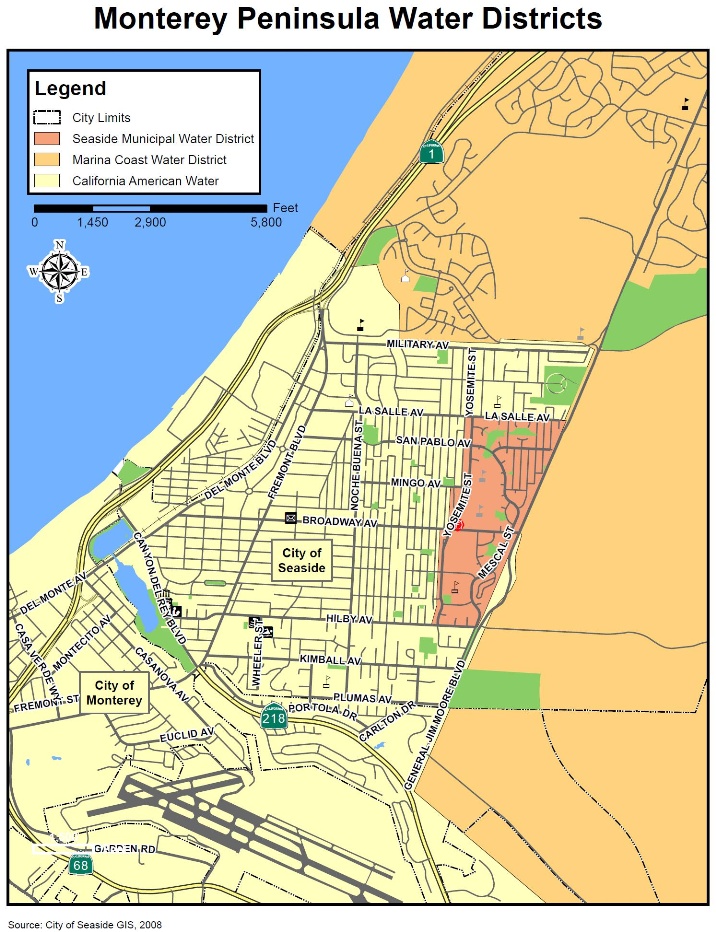
| 15:25, 29 March 2016 | SeasideMunicipalWaterSystemBoundry.jpg (file) |  |
292 KB | Kaitlync | 1 | |
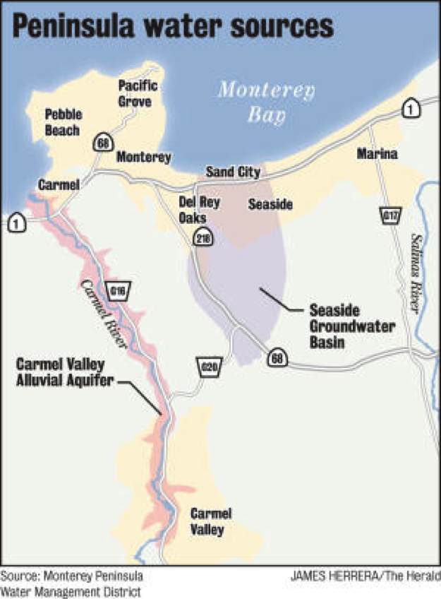
| 13:23, 7 April 2014 | SeasideBasin.png (file) |  |
418 KB | Chelsean | Image from the Monterey Herald. Originally from the Monterey Peninsula Water Management District. http://www.montereyherald.com/ci_23347443/path-your-tap-what-you-need-know-about | 2 |
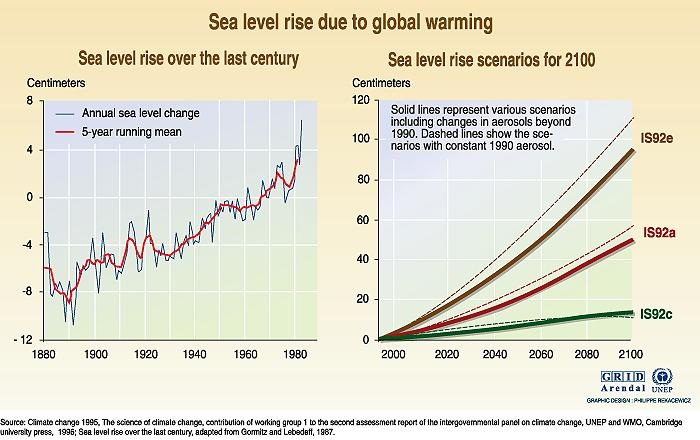
| 19:34, 4 February 2010 | Sea Levels Rising.jpg (file) |  |
94 KB | Mariao | 1 | |
| 20:10, 1 February 2011 | Screen shot 2011-02-01 at 7.09.29 PM.png (file) |  |
207 KB | Rogera | Groundwater levels in Pajaro Valley | 1 |
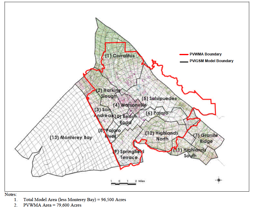
| 19:20, 1 February 2011 | Screen shot 2011-02-01 at 6.19.17 PM.png (file) |  |
447 KB | Rogera | Pajaro Valley Water Management Agency Service Area | 1 |
| 14:00, 9 April 2013 | SantaMbasinboundary.JPG (file) |  |
76 KB | Ambers | 1 | |
| 13:27, 5 April 2016 | SantaLuciaLogo.jpeg (file) |  |
39 KB | Alanak | Santa Lucia Conservancy Logo. Figure from <ref name="SLClogo">Santa Lucia Conservancy website http://www.slconservancy.org</ref> | 1 |
First page |
 Previous page |
 Next page |
Last page |