Search results
From CCoWS Wiki
Create the page "Fred" on this wiki!
- ** Watershed boundary: Watershed analysis in ArcMap by [[Fred Watson]] based on [[National Map]] 1/3 arc-second elevation data * Data analysis: [[Fred Watson]] (watershed boundary)1 KB (143 words) - 06:10, 25 March 2014
- ** Watershed boundary: Watershed analysis in ArcMap by [[Fred Watson]] based on [[National Map]] 1/3 arc-second elevation data * Data analysis: Shaelyn Hession (Aerial Imagery); [[Fred Watson]] (watershed boundary)1 KB (181 words) - 17:46, 12 February 2011
- ** Watershed boundary: Watershed analysis in ArcMap by [[Fred Watson]] based on [[National Map]] 1/3 arc-second elevation data * Data analysis: [[Fred Watson]] (watershed boundary)938 B (118 words) - 16:19, 12 February 2011
- ** Watershed boundary: Watershed analysis in ArcMap by [[Fred Watson]] based on [[National Map]] 1/3 arc-second elevation data * Data analysis: [[Fred Watson]] (watershed boundary)967 B (116 words) - 16:17, 12 February 2011
- ** Watershed boundary: Watershed analysis in ArcMap by [[Fred Watson]] based on [[National Map]] 1/3 arc-second elevation data * Data analysis: [[Fred Watson]] (watershed boundary)1,004 B (129 words) - 16:20, 12 February 2011
- * Data analysis: Kathy Pugh and [[Fred Watson]]2 KB (372 words) - 07:44, 28 February 2011
- Fred thinks this is an awesome page and doesn't need changing.62 B (11 words) - 15:48, 27 March 2012
- Here's a comment [[User:Fred|Fred]] 22:50, 27 March 2012 (UTC)62 B (8 words) - 15:50, 27 March 2012
- ...stormwater discharge through Greenwood Park in Pacific Grove, CA. Image by Fred Watson]]18 KB (2,598 words) - 05:53, 9 April 2016
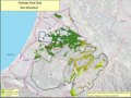
File:OakWoodlands Watson.png Oak Woodlands on Fort Ord created by Fred Watson March 2013(Based on late-1990s(315 × 236 (132 KB)) - 15:49, 28 March 2013- ... community conception spearheaded by CSUMB faculty Dr. Scott Waltz and Dr. Fred Watson. The total cost of the project is estimated at $40 million. In Novem ...ents of the existing Monterey Bay Coastal Recreation Trail. Photo courtesy Fred Watson<ref name ="FORTAG_Gallery"> Fort Ord Rec Trail and Greenway. 2016. G15 KB (2,079 words) - 17:10, 27 March 2020
- * Fred Ledesma - Cities of southern [[Monterey County]]13 KB (1,879 words) - 14:39, 13 April 2020
