Pajaro River
Contents
Location
The Pajaro River drains a watershed of 1,300 square miles in Santa Cruz, Santa Clara, San Benito, and Monterey Counties.
History

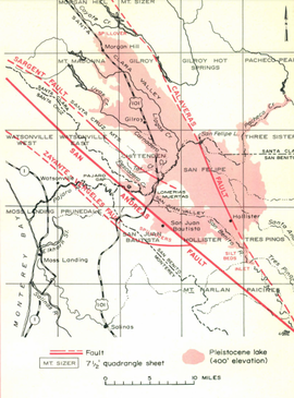
Today the Pajaro River flows in an artificial channel designed by the Army Corps of Engineers from San Benito, Santa Cruz, and Monterey counties discharging out into the Monterey Bay. The modern Pajaro River channel meets the historical Corralitos Creek channel, evolving Corralitos Creek into a tributary. This river is unique as the San Andres Fault continuously changes its path from as far south as the Elkhorn Slough to as far north as its current mouth at Corralitos Creek.[2] During the Pleistocene, landslides at the Pajaro Gap prevented flow resulting in what’s referred to as San Benito Lake east of the San Andres Fault extending as far north as Morgan Hill and eastward past Hollister. While this lake was held back at the Pajaro Gap, there was some spillover south into the Elkhorn Valley. More recently, landslides in that region have caused the formation of smaller lakes such as Soda Lake which is now a Pleistocene remnant. Today the Pajaro River flows freely past the Pajaro Gap and into the Pajaro Valley.[1] During early statehood, there was a ranchero that possibly channelized the lower Pajaro to reclaim the land. It was in 1948 that the U.S. Army Engineers completed the levee channel system on what is now the modern day flow of the river. [2]
Tributaries
Upper watershed tributaries are the San Benito River, Tres Pinos Creek, the overflow of San Felipe Creek from Pacheco and Santa Ana Creeks, LLagas Creek, Carnadero Creek, Uvas Creek, Tar Creek, and Pescadero Creek.[1] Lower tributaries include Corralitos Creek, Salsipuedes Creek, Green Valley Creek, Browns Valley Creek, Casserly Creek, Jesus Creek, Pinto Lake, College Lake, Drew Lake, and Tynan Lake. [3]
Hydrology
Pajaro River inflow derives from precipitation, runoff, and agricultural water percolation. Outflow is attributed to evapotranspiration and heavy groundwater extraction for the purposes of irrigation and municipal use (see Pajaro Valley Groundwater Overdraft Concerns). Mean annual precipitation for this watershed ranges from 18.6 in. to 55 in and is heavily influenced by El Nino Oscillations. Surface water is monitored in three locations: Pajaro River at Chittenden, Corralitos Creek at Freedom, and Corralitos Creek at Corralitos upstream. Surface flow is attributed mainly to winter runoff, and shows losses and gains between Chittenden and Murphy’s Crossing. Reaches between highway 129 and Murphy’s Crossing tend to show loss while reaches on Corralitos Creek north of Freedom gain flow. [4]
Public Access
Public access to the Pajaro River used to be scarce as farmland bordered the majority of the lower river. In 2012, the City of Watsonville received a new park from a state grant promoting access to waterways. Picnic benches, portable restrooms, and trails on the levees were contracted out through Monterey Peninsula Engineering. [5] The City of Watsonville is currently developing a Trails and Master Bike Plan which will include 33 miles of trails to the Pajaro and surrounding wetland systems. [3]
Issues
- Major Flooding Events
- 1955- flood breached levees
- 1982- flooding on tributaries
- 1995- flooding breaches levees below expected capacity
- 1997- flooding on Corralitos Creek
- 1998- flooding on Pajaro [6]
- Levee system
- Water quality
References
- ↑ 1.0 1.1 1.2 Ca Geology. July 1973. “PLEISTOCENE LAKE SAN BENITO” [4 April 2018]. Volume 26:7. Available from: ftp://ftp.conservation.ca.gov/pub/dmg/pubs/cg/1973/26_07.pdf
- ↑ 2.0 2.1 Watershed Institute. July 22, 2003. Pájaro River Watershed Flood Protection Plan. [4 April 2018]. Available from: http://www.pajarowatershed.org/archive/uploads/Flood%20Protection/Watershed%20Studies/Curry%20Flood%20Protection%20Plan%202003.pdf
- ↑ 3.0 3.1 City of Watsonville. “Habitat Restoration and Enhancement Assessment and Plan for Trails Corridors City of Watsonville Trails & Bicycle Master Plan” [4 April 2018]. Available from: https://www.cityofwatsonville.org/DocumentCenter/View/2918
- ↑ Hanson RT, Schmidt W, Faunt CC, Lear J, & Lockwood B. 2014. Integrated hydrologic model of Pajaro Valley, Santa Cruz and Monterey Counties, California: U.S. Geological Survey Scientific Investigations Report. 2014–5111. 166. Available From: https://pubs.usgs.gov/sir/2014/5111/pdf/sir2014-5111.pdf
- ↑ Jones D. Feb 2012. “New Watsonville park promotes public river access” Santa Cruz Sentinel. [4 April 2018]. Available from: http://www.santacruzsentinel.com/article/zz/20120218/NEWS/120217383
- ↑ The Pajaro Watershed Information Center. "Background and Timeline" [5 April 2018] Available from: http://www.pajarowatershed.org/Content/10031/BackgroundandTimeline.html
Links
- Pajaro Valley
- Pajaro Valley Groundwater Overdraft Concerns
- Hollister Hills State Vehicular Recreation Area (SVRA)
- California's Central Coast Region
Disclaimer
This page may contain students' work completed as part of assigned coursework. It may not be accurate. It does not necessarily reflect the opinion or policy of CSUMB, its staff, or students.