Pajaro River
Contents
Location
The Pajaro River drains a watershed of 1,300 square miles in Santa Cruz, Santa Clara, San Benito, and Monterey Counties.
History

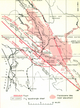
Today the Pajaro River flows in an artificial channel designed by the Army Corps of Engineers from San Benito, Santa Cruz, and Monterey counties discharging out into the Monterey Bay. The modern Pajaro River channel meets the historical Corralitos Creek channel, evolving Corralitos Creek into a tributary. This river is unique as the San Andres Fault continuously changes its path from as far south as the Elkhorn Slough to as far north as its current mouth at Corralitos Creek.[1] During the Pleistocene, landslides at the Pajaro Gap prevented flow resulting in what’s referred to as San Benito Lake east of the San Andres Fault extending as far north as Morgan Hill and eastward past Hollister. While this lake was held back at the Pajaro Gap, there was some spillover south into the Elkhorn Valley. [1]
Tributaries
Hydrology
Public Access
Issues
- Flooding
- Levee system
References
- ↑ 1.0 1.1 1.2 Ca Geology. July 1973. “PLEISTOCENE LAKE SAN BENITO” [4 April 2018]. Volume 26:7. Available from: ftp://ftp.conservation.ca.gov/pub/dmg/pubs/cg/1973/26_07.pdf
Links
- Pajaro Valley
- Pajaro Valley Groundwater Overdraft Concerns
- Hollister Hills State Vehicular Recreation Area (SVRA)
- California's Central Coast Region
Disclaimer
This page may contain students' work completed as part of assigned coursework. It may not be accurate. It does not necessarily reflect the opinion or policy of CSUMB, its staff, or students.