The Carmel River Watershed
From CCoWS Wiki

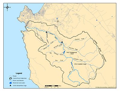
Map of the Carmel River Watershed. Image: MPWMD.
Nestled between the Sierra de Salinas and Santa Lucia Mountain Ranges on the Central California Coast, the Carmel River Watershed is composed of countless small tributaries that all drain into the Carmel River, and eventually the ocean at Carmel River beach.
Contents
Location
Watershed Components
Main Stem
Dams
Subwatersheds
- Pine Creek
- Miller Creek
- Los Padres Creek
- Rana Creek
- Mid-Carmel River
- Hitchcock Canyon
- Las Garzas Creek
- Robinson Canyon
Tributaries
Lagoon
The Carmel River Lagoon connects the Carmel River to the Pacific Ocean in winter months when flows are high. A sandbar forms and closes the river mouth during the late spring and summer months [1].
Physical Characteristics
Hydrology
Geology
Habitat
Sensitive Species
Issues
Water Supply
Dam Removal
- San Clemente Dam Removal
Erosion
Projects
Stakeholders
- Monterey Peninsula Water Management District (MPWMD)
- California-America Water Company (Cal-Am)
- Monterey County Water Resources Agency
- Carmel River Steelhead Association (CRSA)
- ...
Timeline
Pick out key dates from this link
CSUMB Courses Relevant to the Carmel Watershed
Links
- Maps of the Carmel River Watershed
- California Central Coast Gage Locations
- Carmel River Lagoon
- San Clemente Dam
- Reservoirs
- Los Padres Reservoir
- San Clemente Reservoir
- Publications
- CSUMB-CCoWS Carmel Watershed Assessment
- EcoViz:SEP_Focus_Sites
Cite error: <ref> tags exist, but no <references/> tag was found
