The Carmel River Watershed

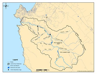
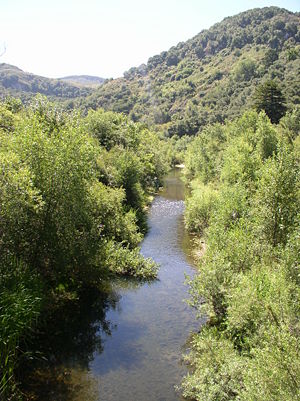
Nestled between the Sierra de Salinas and Santa Lucia Mountain Ranges on the Central California Coast, the Carmel River Watershed is composed of countless small tributaries that all drain into the Carmel River, eventually forming the Carmel River Lagoon at Carmel River beach, which periodically breaches into the Pacific Ocean.[1]
Contents
Location
The Carmel watershed is located located among the Santa Lucia mountains in the California Coast Ranges. The Sierra de Salinas Mountains from the watershed boundary to the northeast while the Santa Lucia Mountains form the border to the southwest.[1] Characterization studies have divided the Carmel River Watershed into 25 subwatersheds based on natural topographic divides.[1]
Watershed Components
Main Stem
The Carmel River main stem is 36 miles long. With its headwaters in the Ventana Wilderness, the upper river is characterized by steep canyons and relatively undeveloped land. The lower 16 miles of river run through moderate to densely developed areas along the alluvial valley floor before reaching the Carmel River Lagoon [2].
Dams
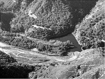
There are two dams on the Carmel River:
Subwatersheds
The Carmel River Watershed incorporates a large range of annual precipitation throughout the watershed and complex geology that gives rise to a complex distribution of soil types, erosion rates, landslide potential, aquifers, recharge areas, ecosystems and human land use. For this reason, proper resource management practices may be very specific to certain watersheds rather than globally relevant. Characterization studies have divided the watershed into 25 subwatersheds based on natural topographic and hydraulic divides.[1] Listed below are links to some of the subwatersheds with prominent issues:
- Pine Creek
- Miller Creek
- Los Padres Creek
- Rana Creek
- Mid-Carmel River
- Hitchcock Canyon
- Las Garzas Creek
- Robinson Canyon
Tributaries
The Monterey Peninsula Water Management District maintains stream guages on several of the tributaries in this region (Table 3). The tributaries generally flow in concert with the regional rainfall patterns (Fig. 21), but also show effects of groundwater influence.[1]
Lagoon
The Carmel River Lagoon connects the Carmel River to the Pacific Ocean in winter months when flows are high. A sandbar forms and closes the river mouth during the late spring and summer months [3].
paraphrase:Artificial breaching of the sandbar (Fig. 63) reduces the frequency of flooding the lagoon wetlands, potentially leading to a shift from freshwater to saline water invertebrate species in some areas of the lagoon. Breaching also lowers the water level artificially fast, potentially leaving steelhead stranded. However, a the would put in place flood and erosion controls that would allow the lagoon to breach naturally without damaging property.[1]
Excess sediment is filling the lagoon with fine material derived from the Carmel Watershed. As the lagoon, including the southern arm, fills in with sediment, there remain fewer deep-water pools and other hiding places for juvenile fish to escape predation. Improved habitat can be achieved through the use of anchored logs or other natural materials.[1]
Physical Characteristics
Hydrology
Precipitation is the only source of water in the Carmel River Watershed and, the water that is not lost to evaporation and transpiration, is transported through the watershed through surface water and groundwater pathways dictated by local water abundance, geologic substrate, annual season, human consumption, and antecedent conditions. Average annual precipitation falls mainly as rain, and varies between 14 inches at the mouth and 41 inches in the Santa Lucia Mountains.[1]
Surface Water
Once water has reached the river channel, it has several potential sinks including groundwater withdrawals in the Carmel Valley, flow to the sea during winter months, evaporation from the stream surface, and transpiration and growth of streamside vegetation.[1] Although most individual claims to water are an insignificant proportion of the watershed hydrologic budget, the collective effect of water use throughout the watershed has resulted in the stream being fully appropriated in summer months, leaving fish populations at risk.[1]
Groundwater
There are two types of aquifers present in the Carmel watershed. By far the most prolific water resource is the unconfined alluvial aquifer underlying the bed, floodplain, and terraces of the Carmel River. The second resource comprises the myriad subtle bedrock aquifers in the complex geology underlying the hills rimming the watershed. Whereas the capacity and hydraulics of the alluvial aquifer underlying the river is well assessed, the upland aquifers that supply the large ranches and a growing number of residences are more complex and less well understood. Of general interest to resource managers and developers is how much development (what extraction rate) those bedrock aquifers can sustain over the long hall, including periods of drought. Also of interest is the impact of upland water use on down-valley water supplies and riparian habitat.[1]
Geology
Geology plays a first order role in determining the physical condition of the watershed and is a complex quilt of igneous, metamorphic and sedimentary rocks in part stitched together by faults of varying ages. The physical strength of the rocks and soils determine the erodibility, landslide potential, and ecosystem and land-use potential. Tectonically, the Carmel Watershed is carved into the Salinian Block, a piece of crust that began its existence near the Mojave desert and moved northward, dragged by the Pacific plate for the past 20 million years.[1]
The Santa Lucia and Sierra de Salinas Ranges have experienced substantial uplift rates for the past two million years. The uplift of the mountains keeps the rivers in a state of general downward incision. Many of the headwater streams and larger tributaries of the Carmel watershed occupy geologically youthful “V”-shaped canyons with sharp dividing ridges, this geometry leads to a naturally high sediment rate and a state of episodic down-cutting of the river channels. This kind of tectonically active, youthful terrain is commonly in balance with slope failure; bherefore, they are very susceptible to slope failure and extremely high sediment yield when disturbed and over steepened during road or subdivision grading.[1]
Lowlands and valleys are typically created where less resistant material is preferentially eroded over a long time, leaving more resistant material as uplands and watershed divides. The Carmel Watershed has physical landscape diversity because it is underlain by a wide range of soils and bedrock types, and because the landscape is cut by myriad active faults. The Carmel Valley owes its character and location to ongoing erosion that has taken advantage of weak rock, crushed in splays of the still active Tularcitos fault zone.[1]
Sensitive Species Habitat
Steelhead: The Carmel River is part of the South Central Steelhead Trout (SH), “Oncorhynchus mykiss” Evolutionary Significant Unit (ESU) and has historically supported a run of now federally listed steelhead.[4] However, the current steelhead population is below historic numbers for the Carmle river and is well below populations found in Northern California coastal streams. Likely factors contributing to this decline include habitat fragmentation and degradation, introduced non-native predator species, impaired fish passage, and water diversions that alter natural streamflows.[5]
Red-legged Frogs: Although these frogs are found in many areas within the watershed, it is unclear whether the population is growing, shrinking, or stable. Most of the information gathered about this species is from observations in the Carmel River lagoon, along the main stem, and at San Clemente Reservoir.[5]
Issues
Watershed issues in the Carmel Watershed are complex and diverse, involving many stakeholders representing many sometimes conflicting uses of water.
Water Supply
California American Water (CalAm) extracts water from wells along the river for use by the residents of the Monterey Peninsula, as described here: CalAm Use of Carmel River Groundwater Basin. CalAm is currently making illegal diversions from the Carmel River, according to California State Order 95-10, in order to meet the water demand of the community [6]. Water supply projects incorporating a desalination plant have been proposed by CalAm and local government agencies, as well as private parties [7]. The Monterey Peninsula Water Management District (MPWMD) has initiated Aquifer Storage and Recovery (ASR) projects to capture and store excess winter flows for use during the summer months [8].
Dam Removal
Incremental motion between the Pacific and North American tectonic plates has periodically broken the crust in the Carmel Watershed. Various studies have determined that several faults show evidence of motion in Quaternary time (< 2 million years) and some have moved much more recently. The trace of the Cachagua fault is covered by the sediment stored in San Clemente Dam and it is estimated that a severe earthquake with a magnitude of up to 7.1 could hit the basin on the Tularcitos fault system, which is not far away. Therefore, San Clemente Dam is among the least safe in California. In addition to seismic hazard, sedimentation issues also drive efforts to promote dam removal.[1]
Erosion
The chief erosive processes in the Carmel Valley are bedrock landslides, shallow soil slips, rock fall, stream incision and widening, and slope gullying. Grading for roads and buildings locally over-steepens these slopes, greatly accelerating the rate of slope failure and erosion. For this reason, nearly the entire Carmel Watershed is rated as highly susceptible to erosion. However, sediment sources that maintain fish spawning habitat are impeded by the San Clemente and Los Padres dams, reducing their capacity to 90% and 50%, respectively. Additionally, in response to sediment starvation, the river channel has cut downward into its bed several meters, leaving a generally narrower, single-thread channel, with a well-defined riparian corridor.[1]
Flooding
The greatest flood during the 48 years of the Rio Robles Stream Gauge operation was the 1995 flood with approximately 16,000 cfs. That event roughly corresponds to the 65-year flood. The next highest flood caused significant damage in 1998 with a 14,700 cfs flow. As determined by Monterey County, construction of structures, grading, or any activity that requires a permit from a government agency shall not be permitted within 200 feet of a riverbank or within the 100-year floodplain (floodway), unless a special permit is granted. Although the regulatory boundary of the Carmel 100-year flood is clearly defined by the County of Monterey (Monterey County Zoning Ordinance, 21.64.130), the true position of that river shoreline is highly imprecise. Extensive urbanization from the narrows to the mouth of the Carmel River lies within the 100-year floodplain, leaving Carmel residents and businesses at risk of significant loss.[1]
Projects
- Carmel River Lagoon Restoration Plan [9]
- Carmel River Restoration Projects carried out by MPWMD [10].
- Carmel River Parkway Plan for river restoration, education, and trails [11].
- ...
Stakeholders
- Monterey Peninsula Water Management District (MPWMD)
- California-America Water Company (Cal-Am)
- Monterey County Water Resources Agency
- Carmel River Steelhead Association (CRSA)
- ...
Timeline
Listed below is a brief timeline of water rights and dam operation in the Carmel River Watershed. A more exhaustive timeline is availabe at Carmel River History.
- 1883 First known dam on the river created ½ mile below site of the current San Clemente Dam.
- 1905 To increase capacity, Pacific Imp. drills six wells near the lower end of Laureles Ranch, installs pumps
capable of drawing 2M gallons per day, and begins installing a larger pipe thru the valley and around the peninsula.
- 1919 S.F.B. Morse forms the Del Monte Properties Co. and purchases Pacific Improvement Co.’s Monterey
holdings for $1.3M.
- 1921 Carmel River becomes site of several mining operations along the lower river, including the Carmel
River lagoon
- 1930 Morse sells water system to Chester Loveland.
- 1931 Loveland raises water rates. Proponents of a public ownership estimate the cost at $1.8-$2M to
purchase water rights. First debate over public, or private water, management.
- 1935 Public ownership of water supply defeated 2 to 1.
- 1939 CW&T provides water to 7,430 Peninsula customers, irrigates 5 golf courses and services a growing
sardine cannery industry.
- 1947 San Clemente Dam is 25% silted. A filter plant opens near San Clemente Dam, improving water
quality. CW&T releases plans for the Los Padres dam, along with other improvements. Total cost $1.4M. Application for 19,000 af per year storage capacity was objected by steelhead fishermen and farmers. SWRCB grants 6,000 af per year and limits season of diversion to 10/1-5/31.
- 1953 Flood event. Rainfall at Los Padres dam was 2.11 inches in 24 hours and Carmel Valley received 1.48
inches. Carmel Valley residents compare the 1958 flood to the 1995 and 1998 floods.
- 1959 Monterey Peninsula Water Mgmt. District initiates efforts to buy out CW&T.
- 1965 In the September election, the measure was defeated 10,766 to 3,053. Loveland sells CW&T to
American Water Works Company.
- 1966 American Water Works Company creates California-American Water Co. to manage the operations of
CW&T systems.
- 1970 Cal-Am announces Peninsula water shortage. Current use is at 15,000 af per year. Cal-Am proposes a
dam in two stages.
- 1971 Cachagua dam project abandoned. A new San Clemente dam is proposed that would create a 40,000
af reservoir and yield 21,000 af per year. Army Corp. of Engineers recommends a flood control component versus the original dam.
- 1977 Monterey Peninsula Water Management District is created to augment, protect and manage water
resources
- 1995 Vote to fund construction and operation of the new Los Padres dam project is rejected 57% to 43%.
- 1996 ESA listing (threatened) on the red legged frog (Rana aurora draytinii).
- 1997 ESA listing (threatened) on steelhead trout (Oncorhynchus mykiss).
CSUMB Courses Relevant to the Carmel Watershed
References
- ↑ 1.00 1.01 1.02 1.03 1.04 1.05 1.06 1.07 1.08 1.09 1.10 1.11 1.12 1.13 1.14 1.15 1.16 Physical and Hydrologic Assessment of the Carmel River Watershed California
- ↑ Carmel River Watershed:Water Supply Perspective
- ↑ California State Parks
- ↑ Carmel River Watershed Conservancy
- ↑ 5.0 5.1 MPWMD Environmental and Biological Assessment of Portions of the Carmel River Watershed Monterey County, California
- ↑ CA State Order 95-10
- ↑ Monterey County Herald
- ↑ MPWMD Water Supply Projects
- ↑ Carmel River Lagoon Restoration Plan
- ↑ MPWMD Restoration Projects
- ↑ Big Sur Land Trust - Carmel River Parkway Plan
Links
- Maps of the Carmel River Watershed
- California Central Coast Gage Locations
- Carmel River Lagoon
- San Clemente Dam
- Reservoirs
- Los Padres Reservoir
- San Clemente Reservoir
- Publications
- CSUMB-CCoWS Carmel Watershed Assessment
- EcoViz:SEP_Focus_Sites
Disclaimer
This page may contain student work completed as part of assigned coursework. It may not be accurate. It does not necessary reflect the opinion or policy of CSUMB, its staff, or students.

