CEQA Summary of The Collection at Monterey Bay Resort
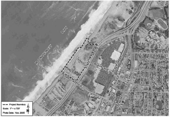
The Collection at Monterey Bay is a resort complex, proposed by King Ventures of San Luis Obispo, that calls for development of a 342 room resort west of Highway 1 on 26 shorefront acres immediately north of Tioga Avenue.[1]
Contents
Project Summary
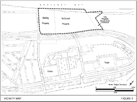
The proposed resort development project site is located in Sand City on the Monterey Bay coastline, west of State Route 1, north of Tioga Avenue. The project is described in two phases. The first phase would be a 139-room hotel and parking garage; the second phase would include a 203-room hotel, two restaurants, a 19,700 square foot restaurant and a Tapas Bar, a 16,800 square foot conference center, a 14,000 square foot spa as well as a juice bar, wine center and parking. [2] This combined resort project would have a total of approximately 350 visitor lodging units. Primary access will be from Playa Avenue and Sand Dunes Drive. The first phase would develop the 7 acre location known as the "Sterling/Calabrese Site", while the second phase would develop the 15.5 acre property referred to as the "McDonald Site." The adjacent 2.3 acre property owned by the Granite Construction company may also be used for additional project parking overflow and general public parking purposes. [3]
CEQA Documents
This project is still a proposal and has not been approved. Listed below are the CEQA documents that have been submitted to date as part of the CEQA process:
Notice of Preparation
- Received April 12, 2006
- Review Period: April 12 to May 11, 2006 [3]
Draft Environmental Impact Report
- Received November 16, 2012 [4]
- Review Period: November 16, 2012 to January 15, 2013
- Draft EIR Contributors:[3]
- David J. Powers & Associates, Inc. Environmental Consultants & Planners
- Donald Ballanti, Certified Consulting Meteorologist Air Quality Consultant
- Fehr & Peers Associates, Inc. Transportation Consultants
- Haro Kasunich & Associates Civil Engineers
- Illingworth & Rodkin Acoustical Consultants
- Nielsen and Associates Engineering Geology Consultants
- Zander Associates Biological Resources Consultants
Revised Draft Environmental Impact Report
- January 14, 2013 - Seaside City Council voted unanimously to call upon Sand City to produce a revised Draft EIR [1]
Draft EIR Comments Submitted
- February 2013 - The Ventana Chapter of the Sierra Club submitted comments in response to the Draft EIR. The Chapter retained attorney Larry Silver and Coastal Ecologist and Botanist Peter R. Baye, Ph.D to submit comments.[2]
Notice of Determination
- No notice of determination has been made at this time, the project remains in the EIR process.
Project Issues
Potential issues identified in the Draft EIR include: Population/Housing Balance, Traffic/Circulation, Water Quality, Geologic/Seismic, Biological Resources, Air Quality, Aesthetic/Visual, Noise, Toxic/Hazardous, Public Services, Other Issues (Cultural Resources, Energy Resources) [3] All impacts were found by the Draft EIR to be less than significant with mitigation. Select specific impacts and proposed mitigation strategies are outlined below.
Visual and Aesthetic Resources
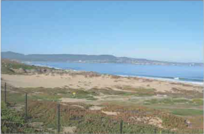
Impact: The proposed project would block portions of the designated view corridors on the site identified in the City’s Local Coastal Program, which would be a significant visual impact.
Mitigation: Impact will be reduced by a bike path along ocean side of project, improved vista points, and reducing building height in specific view corridors.[4]
Transportation
Impact: The proposed project would result in significant impacts to line of sight at Fremont Boulevard, State Route 1, Monterey Road, Ord Avenue, and significant traffic impacts to Northbound and Southbound State Route 1.
Mitigation: The proposed project will be required to pay the TAMC Regional Development Impact Fee as a fair share contribution to regional transportation improvements to mitigate the project’s impact to this freeway segment to a less than significant level.[4]
Hydrology and Water Quality
Impacts: The Collections at Monterey project will be subject to wave run-up and coastal flooding over the lifetime of the development.
Mitigation: Wave run-up and coastal flooding hazards can be mitigated by the structural design of the proposed buildings, elements and facilities. Breakaway walls, flow through design, appropriate foundation types, floodproofing measures, and necessary structural force field selection should be considered prior to final project design, in accordance with FEMA guidelines. A final, design-level geotechnical investigation for the project shall be completed for the applicant by a qualified geotechnical consultant and shall be reviewed and approved by the City Engineer.[4]
Geology and Soils
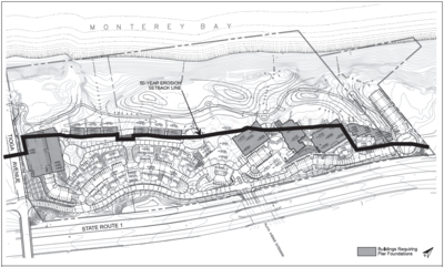
Impacts: Coastal erosion and recession will significantly impact elements of the project located seaward of the 50-year coastal erosion setback line. For more information on coastal erosion mitigation impacts see Coastal Erosion and Armoring in Southern Monterey Bay (NOAA Sea Grant, Monterey Bay Seawalls (CSUMB) and Are "Stable Shorelines" and "Broad Beaches" Mutually Exclusive Management Goals Along Southern Monterey Bay? (CSUMB) Wind erosion and sand deposition would likely result in project amenities being unusable over the life of the project.
Mitigation: Proposed structures will be supported by appropriate pier and grade beam systems or shallow conventional spread footings depending on proximity to the 50-year erosion line. The establishment of planted dune vegetation and the incremental installation of sand fences is expected to reduce the impact of wind erosion.[4]
Biological Resources
Impacts: The project would result in the loss of several Monterey spineflower plants. Although the removal of these plants would not affect the survival of the species, the loss of the individual plants of this threatened species is a significant impact. The project could result in the removal of habitat for western snowy plover and, therefore, would have a significant impact on the species. The removal of seacliff and coast buckwheat plants as a result of the project would result in significant impacts to Smith’s blue butterflies and their dispersal. The project will remove potential habitat for the black legless lizard and could result in the loss of individual black legless lizards.
Mitigation: Implementation of a Habitat Protection Plan for the proposed site that includes revegetation efforts, pre-construction surveys, designation of biological steward during the snowy plover breeding season, and limit access during breeding season. Additionally, search and relocation efforts for the black legless lizards.[4]
Air Quality
Impacts: Construction activities, such as, clearing, excavation, and grading operations, construction vehicle traffic, and wind blowing over exposed earth would generate fugitive particulate matter emissions that would temporarily affect local air quality.
Mitigation: Implementation of a dust abatement program during construction.[4]
In the News
Monterey Herald - Seaside Calls for Revised EIR on Proposed Sand City Resort
Santa Cruz Sentinel - Latest Sand City Coastal Resort Project Releases Draft EIR
Chapter Submits Comments on Collections at Monterey Bay Proposed Mega Hotel Complex in Sand City
Agencies
Reviewing Agencies: Resources Agency; California Coastal Commission; Department of Fish and Wildlife, Region 4; Department of Parks and Recreation; Department of Water Resources; Caltrans, Division of Aeronautics; California Highway Patrol; Caltrans, District 5; Regional Water Quality Control Board, Region 3; Native American Heritage Commission; State Lands Commission [4]
References
- ↑ 1.0 1.1 Monterey Herald - Seaside Calls for Revised EIR on Proposed Sand City Resort
- ↑ 2.0 2.1 Chapter Submits Comments on Collections at Monterey Bay Proposed Mega Hotel Complex in Sand City
- ↑ 3.0 3.1 3.2 3.3 CEQANet Database
- ↑ 4.0 4.1 4.2 4.3 4.4 4.5 4.6 4.7 4.8 Draft EIR
Links
- CEQA Overview
- CEQA Glossary
- Ocean Harbor House Seawall
- California Coastal Commission
- Agencies that are lead applicants in CEQA
- Hydrology and Water Quality Components of Central Coast CEQA Documents
- CEQA projects on Central Coast
- CEQAnet Project Description SCH Number 2006041070
- Local Coastal Programs in California's Central Coast Region
Disclaimer
This page may contain students's work completed as part of assigned coursework. It may not be accurate. It does not necessarily reflect the opinion or policy of CSUMB, its staff, or students.


