Landslides and Debris Flows in the California Central Coast Region
An environmental summary created by the ENVS 560/L Watershed Systems class at CSUMB.
Contents
Summary

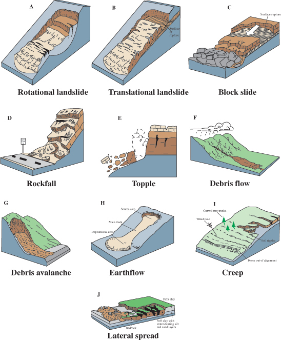
Landslides are a characterized as the falling or movement of soil or rock down a slope and can manifest through mudflows, mudslides, debris flows, rock falls, rockslides, debris avalanches, debris slides, and slump-earth flows.[1] This movement occurs when the down-slope force exceeds the strength of the soil or other material holding the slope together.[2] Typically, landslides take time to initiate movement as the soil saturates and ultimately moves at a slow pace, but can cause significant damage to buildings and other infrastructure. [3] Debris flows, a type of landslide, occur suddenly with shorter and intense rainfall creating a slurry that moves at a rapid pace and often can result in loss of life making them more dangerous.[3]
In the United States, landslides are an extremely destructive hazard. Landslides in the country cause approximately $3.5 billion in damage, and kill between 25 and 50 people annually.[4] On a more local scale, landslides are one of the most costly geologic hazards in Monterey County, costing millions of dollars yearly in infrastructure damage.[5] Surrounding Monterey, many other regions are prone to landslides. Along the coast, between Point Lobos State Natural Reserve and Capoforo Creek, 1,500 landslides were mapped in 2001 which indicated slope-failure is common.[6] Additionally, Los Padres National Forest contains at least 250 active landslide sites and over half of the forest is highly susceptible to slope failures.[7] In Hollister, the hillslopes are susceptible to slope failure as well. Creep, slump, and other earthflows are common in the area.[8] In California's Central Coast Region, landslides and debris flows are common due to rainfall and steep slopes. Other causes are present in the region which facilitate landslide occurrences.
Causes
Precipitation
Precipitation is the major influence on landslides.[9] Rainfall intensity, duration, and frequency are important factors related to slope failure. Many deep-seated landslides occur after prolonged, intense rainfall and towards the end of the rainy season as soil becomes fully saturated, weakening the stability of a slope.[10] Because of the high precipitation, runoff, and soil saturation, landslides and flooding are often correlated.[4] During El Nino events, Central California can be exposed to extreme rainfall and subsequently a higher risk of landslides.[1] During these times, debris flows and floods are often mistaken for each other and could occur simultaneously.[4] Frequent slope failures from heavy precipitation are common in the Big Sur Region, the Carmel River Watershed, and most of Monterey County.[9][11][5]
Wildfire and Vegetation
Another common natural impacts leading to landslides is wildfire. Wildfires in the Central Coast Region remove vegetation and their root structures, leaving the soil unstable and prone to erosion and slope failure.[7] Without the reinforcement of a root system, post-fire areas are highly susceptible to landslides when rainfall occurs.[12]
Earthquakes
A less common inducer of landslides is seismic activity. Although, the combination of earthquakes and another event could create potential for landslide activity.[7] Monterey County sits on a variety of faults which create fractured, or weak, rock and rapidly uplifting mountains.[5] The combination of this with high precipitation makes landslides common in the region. The Carmel and Arroyo Seco Watershed also cover fractured granite and marble rock formations.[5][11] The weakness in these geologic units, coupled with seismic activity, can be related to an abundance of landslides.[9]
Development
Development of roads and buildings often require grading and excavation which steepen a slope, making it less stable. An example of this occurred in 2001, when illegal road construction in the Garrapata Creek Watershed led to unnaturally high sedimentation of steelhead habitat caused by sediment from roadwork sliding off the cliff face into Joshua Creek[13] Development has been another input for landslide susceptibility.[7][11] Development has shown an impact in many areas of the county, but the steep hillsides of the Carmel Watershed have seen the result of additional landslide hazard zones due to the development of roads and subdivisions.[11] In the area, trails and access roads continue to be at risk of slope instability.[14]
Prediction and Mitigation
Landslides are dangerous and costly events that are common in the Central Coast Region. It is important to identify additional impacts, ways to predict where and when a landslide could occur, and way to prevent their negative effects.
Problems
- Landslides create a lot of extra natural and anthropogenic sediment which can harm fish populations, including endangered Steelhead.[6][7]
- Sediment also impacts water quality standards.[15]
- Infrastructure maintenance and cost due to continuous or repeated landslide activity:
- Landslides into a reservoir can compromise dam safety and the excess sediment can harm the efficiency of the dam. [1]
Mitigation
Landslides are a natural occurrence that often cannot be prevented. The best ways to prevent damages are to be prepared and inform people of the dangers. Additionally, areas of high susceptibility could be avoided. Also, restoration through re-vegetation of wildfire areas and other reinforcements of soil during and after development could be beneficial. At Los Padres Reservoir, there are proposals for how to reduce the impact of sediment behind the dam by way of a sluicing tunnel.[16] Additionally, Caltrans is working proactively to find sediment disposal sites away from the Monterey Bay National Marine Sanctuary (MBNMS) for habitat restoration from future landslides.[17]
Prediction
Most of the effort toward landslides focuses on prediction. Knowledge of how to know when and where a slide would occur could prevent damages and loss of life. Some of the most popular forms of landslide detection are precipitation driven. Empirical Rainfall Thresholds (ERT) and Intensity-Duration (ID) thresholds are commonly used worldwide and constantly have studies on how to improve upon them.[18][19] While these methods have been helpful, there is a market for improvement. Some methods include:
- regional hydro-meteorological hazard assessment[20]-to improve on ID
- nonstationary intensity-duration-frequency (IDF) curves to account for climate change and the increase of heavy rain events[21]
- accounting for groundwater as a landslide source[22]
- use of satellite imagery, remote sensing, and GIS tools (i.e. dNDVI[23], photogrammetry[24], DEM and LiDAR[25]
- software like LAPSUS_LS[26] and ISATIS Geovariances[18]
Major Events

The following events are listed in order from North to South:
- Saddle Mountain Debris Slides occured from 1997-1998 and impacted Saddle Mountain Recreation Area and resulted in 1 death.[1]
- Las Lomas Mudslide in 1998 destroyed 8 residential properties which were then bought by the county and made into open space.[27]
- Bixby Creek Bridge Landslide took down almost 40 feet of Highway 1 and shut down the highway for over 3 months in March 2011.[1]
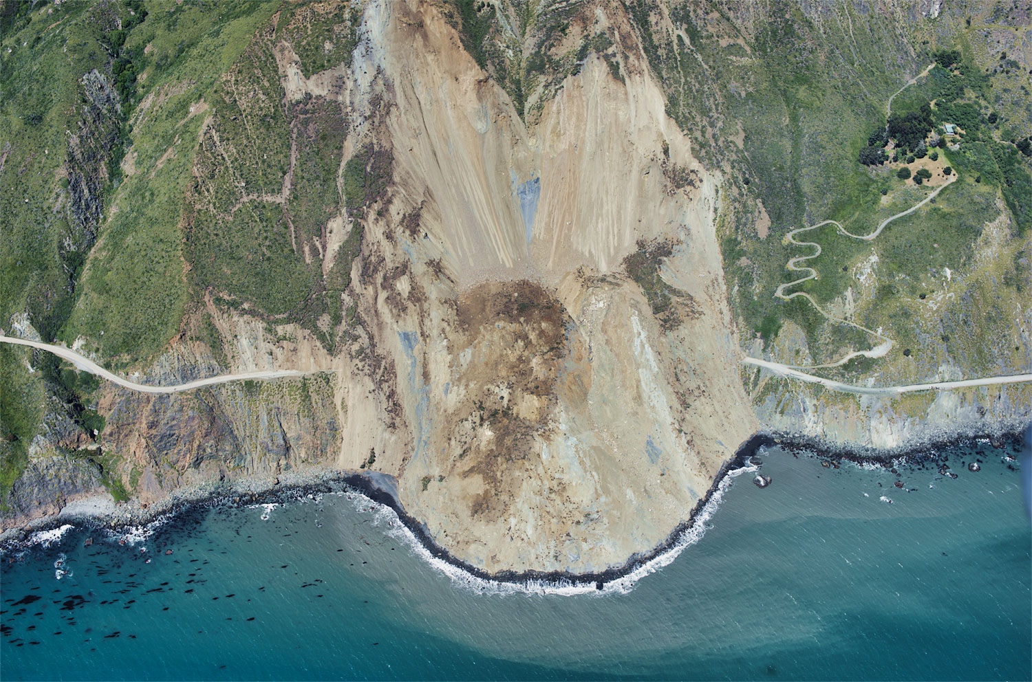
- Mud Creek Slide and Paul's Slide both occurred in 2017 after an extreme rain season and destroyed portions of Highway 1.[1] The section of the highway fallen by Paul's Slide was rebuilt after 6 months and the Mud Creek Slide created an additional 13 acres on California's coast.[28]
- McWay Slide triggered by heavy rainfall in the winter of 1983. The slide was the largest slide ever recorded on that segment of Highway 1.
- Pitkin's Curve Debris Slide a landslide below the road caused Caltrans to move a section of Highway 1 inland, but the cut slope required to move the highway resulted in entire slop failure. Rather than continuing repairs of the highway or attempting to stabilize the cliff face, Caltrans designed a bridge to bypass the slide area.[29][30]
References
- ↑ 1.0 1.1 1.2 1.3 1.4 1.5 Monterey County Office of Emergency Services
- ↑ USGS Natural Hazards
- ↑ 3.0 3.1 California Department of Conservation
- ↑ 4.0 4.1 4.2 4.3 USGS Landslide Types and Processes Fact Sheet
- ↑ 5.0 5.1 5.2 5.3 Geologic Resources and Constraints in Monterey County: A Technical Report
- ↑ 6.0 6.1 [http://ccows.csumb.edu/pubs/reports/CCoWS_CRWC_CarmAssPhysHyd_041101.pdf CCoWS Physical and Hydrologic Assessment of the Carmel River Watershed
- ↑ 7.0 7.1 7.2 7.3 7.4 USDA Forest Service Geology-Landslides
- ↑ 8.0 8.1 USGS Field Trip of The Calaveras and San Andreas Faults In and Around Hollister
- ↑ 9.0 9.1 9.2 9.3 Department of Conservation Special Report on Landslides for the Coast Highway Management Plan
- ↑ USGS Rainfall and Landslides in Northern and Central California
- ↑ 11.0 11.1 11.2 11.3 Los Padres Dam and Reservoir Long-Term Strategic and Short-Term Tactical Plan 2014
- ↑ USA Today 2018 Thomas Fire Article: CDC Quote
- ↑ Spenser A. 2001. A Big Sur newcomer's improvements draw the ire of neighbors and the county. [1].
- ↑ Final EIR/EIS San Clemente Dam Seismic Safety Project
- ↑ Proposed Resource Management Plan Final EIS for the Southern Diablo Mountain Range and Central Coast of California
- ↑ Los Padres Dam and Reservoir Alternatives and Sediment Management Study Draft Alternatives Descriptions Technical Memorandum
- ↑ Monterey Bay National Marine Sanctuary Resource Issues: Landslides and Debris
- ↑ 18.0 18.1 "Regional rainfall threshold maps drawn through multivariate geostatistical techniques for shallow landslide hazard zonation"
- ↑ "Triggering threshold precipitation and soil hydrological characteristics of shallow landslides in granitic landscapes"
- ↑ "Hydrological perspectives on precipitation intensity-duration thresholds for landslide initiation: proposing hydro-meteorological thresholds"
- ↑ "Nonstationary Precipitation Intensity-Duration-Frequency Curves for Infrastructure Design in a Changing Climate"
- ↑ "Towards hydrological triggering mechanisms of large deep-seated landslides"
- ↑ "Post-fire debris flow modeling analyses: case study of the post-Thomas Fire event in California"
- ↑ "Characterizing the catastrophic 2017 Mud Creek landslide, California, using repeat structure-from-motion (SfM) photogrammetry"
- ↑ "Remote Sensing of Landslides—A Review"
- ↑ "Sensitivity of the landslide model LAPSUS_LS to vegetation and soil parameters"
- ↑ Monterey County Water Resource Agency: Historical Flooding
- ↑ USGS News: Huge landslide on California’s Big Sur coast continues to change
- ↑ Wills C, Manson M, Brown K, Davenport C, Domrose C. 2001. Landslides in the Highway 1 Corridor: geology and slope stability along the Big Sur coast between Point Lobos and San Carpoforo Creek, Monterey and San Luis Obispo counties, California. [2]
- ↑ MNS Engineers Inc. 2013. Pitkins Curve: transportation construction management. https://www.mnsengineers.com/news/pitkins-curve-and-rain-rocks-mns-transportation-construction-management/]
Links
- Carmel River Watershed
- Los Padres National Forest
- Hollister
- Monterey County
- Wildfires
- Garrapata Creek Watershed
- Central Coast Region
- Steelhead
- Water quality standards
- Reservoir
- Big Sur
Disclaimer
This page may contain students' work completed as part of assigned coursework. It may not be accurate. It does not necessarily reflect the opinion or policy of CSUMB, its staff, or students...