Carmel River Floodplain Restoration and Environmental Enhancement (Carmel River FREE) Project
An environmental topic examined by the ENVS 560/L Watershed Systems class at CSUMB.

Contents
Summary
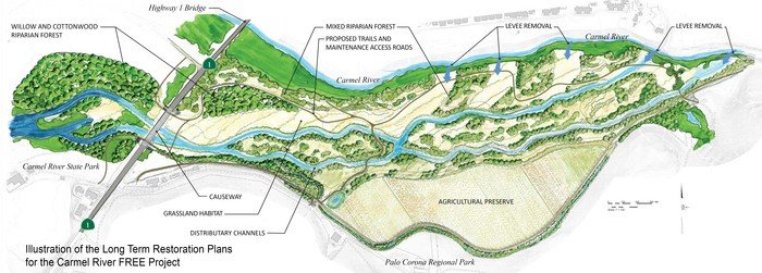
The Carmel River Floodplain Restoration and Environmental Enhancement Project (Carmel River FREE) is a collaboration between the Big Sur Land Trust (BSLT) and the County of Monterey Resource Management Agency to reduce the flood risk for businesses and residences in the Lower Carmel Valley and restore the active floodplain. The project encompasses the following components: [1] [2] [3]
- Removal of 1,470 ft of levee on the south side of the Carmel River to allow river access to the Odello East floodplain,
- Replace 360 ft of the Highway 1 roadway with an elevated causeway to allow floodwater movement under the highway and connect the floodplain to the Carmel River Lagoon,
- 100 acres of agricultural land graded to mimic the historic floodplain including braided off-stream channels and depressions for sediment settlement,
- 90 acres of riparian and grassland habitat restoration and monitoring,
- 23 acres reserved for organic agriculture, elevated above the 100-year floodplain.
Construction is projected to begin in early 2018 and be completed within a year. [4]
Location
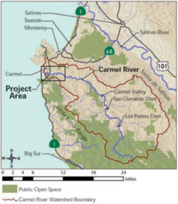
Carmel River FREE will restore floodplain in the Lower Carmel Watershed in Carmel Valley, Monterey County, California. The project site is east of the Highway 1 bridge over the Carmel River.
Background
In 2010 BSLT proposed alleviating the risk of flooding in the Lower Carmel Valley by restoring the floodplain instead of expensive levee reinforcements. [5]
Part of the Carmel River State Beach and Palo Corono Regional Park were contributed by California State Parks and the Monterey Peninsula Regional Park District to Carmel River FREE. Clinton and Margaret Eastwood are donating 82 acres (the Odello East parcel) to add to 49 acres already owned by the Big Sur Land Trust. [2] Water rights for the Odello East property will be re-allocated from crop irrigation to river and lagoon enhancement (46.2 acre-feet per year (afy)) and municipal use (85.6 afy). Cite error: Closing </ref> missing for <ref> tag Floodplain restoration will give water in the Carmel River an appropriate place to spill over in high flow events so that businesses and residences are protected. Without Carmel River FREE, the County of Monterey would have to reconstruct existing levees to meet Federal Emergency Management Agency (FEMA) standards, costing an additional $14 million. [2]
Public access
Carmel River FREE includes plans for recreational trails that will connect Carmel River State Beach with Palo Corona Regional Park.
Funding
The total estimated cost of Carmel River FREE is $24 million. [2]
The Big Sur Land Trust secured $14 million from the California Water Resources Agency, US Environmental Protection Agency, US Fish and Wildlife Service, California Coastal Conservancy, California Department of Transportation, and California Wildlife Conservation Board. [4]
The 2014 Monterey County Service Area 50 Flood Control Report [6] estimated that the Carmel River FREE project would reduce the cost of flood control improvements from $25,771,000 to $11,322,000.
CEQA/NEPA
The US Fish and Wildlife Service and Monterey County are the lead agencies for NEPA and CEQA documents, respectively. A combined CEQA/NEPA draft is under review and will be available to the public in the summer 2016. [2]
Methods and Tools
Hydrologic and floodplain modeling...
Parties Involved
Organizations
Agencies
Consultants
Community Members
- Residents of Monterey County Service Area 50
- Clinton and Margaret Eastwood
Links
References
- ↑ Carmel River FREE, BLST blog
- ↑ 2.0 2.1 2.2 2.3 2.4 Carmel River FREE handout, BSLT
- ↑ Lower Carmel River and Lagoon Floodplain Restoration and Environmental Enhancement Project, BSLT
- ↑ Carmel River FREE Project hopes to relegate flooding to history, Monterey County NOW
- ↑ CSA-50 Final Lower Carmel River Stormwater Management and Flood Control Report
Disclaimer
This page may contain student work completed as part of assigned coursework. It may not be accurate. It does not necessary reflect the opinion or policy of CSUMB, its staff, or students.