Difference between revisions of "Municipal Water Service Boundaries in Southern Monterey Bay Region"
(→Summary) |
(→CalAM Boundaries) |
||
| Line 16: | Line 16: | ||
*Private water companies/ wells | *Private water companies/ wells | ||
| − | == | + | == CalAm Boundaries == |
In 1966 CalAm purchased the southern Monterey Bay's water infrastructure from the California Water and Telephone Company. This purchase included the [[San Clemente Dam]] and [[Los Padres Dam]]. Since then, CalAm has been providing water to approximately 85 % of the Peninsula . | In 1966 CalAm purchased the southern Monterey Bay's water infrastructure from the California Water and Telephone Company. This purchase included the [[San Clemente Dam]] and [[Los Padres Dam]]. Since then, CalAm has been providing water to approximately 85 % of the Peninsula . | ||
Revision as of 13:59, 5 April 2016
Summary of southern Monterey Bay's municipal water boundaries.
This information is by the ENVS 560/L Watershed Systems class at CSUMB.
Contents
Summary
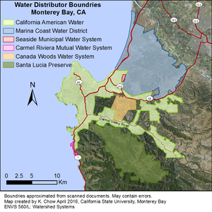
Monterey Bay has several water providers ranging from large agencies such as MCWD and CalAm, small private water districts, and private wells. The boundaries of these entities are the result of historic purchases, legal action, and development.
Southern Monterey Bay Municipal Water Agencies
Multiple agencies serve Monterey Bay's water needs including, but not limited to:
- California American Water Company (CalAm)
- Seaside Municipal Water System [1]
- Marina Coast Water District (MCWD)
- Private water companies/ wells
CalAm Boundaries
In 1966 CalAm purchased the southern Monterey Bay's water infrastructure from the California Water and Telephone Company. This purchase included the San Clemente Dam and Los Padres Dam. Since then, CalAm has been providing water to approximately 85 % of the Peninsula .
CalAm's extent encompasses portions of Seaside, the City of Monterey, Pacific Grove, Pebble Beach, Carmel, Carmel Highlands, Carmel-by-the-Sea, and Carmel Valley [2].
- 1989 - CalAm acquired the Ryan Ranch water facilities
- 1993 - CalAm acquired and annexed the Hidden Hills Unit, which formerly reported as the Carmel Valley Mutual Water Company [3]
- 1999 - The Bishop Unit, which was operated by Cal-Am since September 1996, was acquired and annexed into the Cal-Am water system [4]
MCWD Boundaries
The Marina Coast Water District (MCWD) has been the main water purveyor for the City of Marina since it's establishment in 1958. The original boundaries were set to coincide with the existing fire service boundaries of the Marina Fire District.
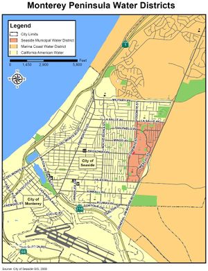
In 1997, with the closer of the Fort Ord Army Base, MCWD entered into an agreement to manage the form Army's water infrastructure. This was finalized by the Board of Directors in 2001 [5]. Half of the the City of Seaside's water infrastructure lies within the boundaries of Fort Ord which was annexed into MCWD's distribution system with Fort Ord lands.
- 2013 - MCWD increased boundaries to include Seaside High School [6]
Seaside Municipal Water System Boundaries
Between CalAm and MCWD boundaries is the Seaside Municipal Water System within the City of Seaside. The Seaside Municipal Water System is small municipal water system composed of one groundwater well and two 500,000 gallon water tanks.
Small Private Water Companies/Wells
Multiple private wells exist on the Monterey peninsula including the Santa Lucia Preserve.
The Monterra Ranch and Tehama Subdivisions are serviced by a small company called Cañada Woods Water Company Water Distribution System (CWWCWDS) [7]

