Los Padres Reservoir Capacity Issues
A watershed-related issue examined by the ENVS 560/L Watershed Systems class at CSUMB.
Contents
Summary
The Los Padres Dam was built in 1949 on the Carmel River as an alternative water storage facility for the Monterey Peninsula. The Dam was built in response to an increase in sediment accumulation behind the downstream San Clemente Dam, which was built in 1921. Water stored in the Los Padres Reservoir is released during the low-flow season to allow water infiltration into the Carmel Valley Aquifer. California American Water Company (CalAm) owns, and operates, the dam and pumps water from the Carmel Valley Aquifer to supply the Monterey Peninsula with water.
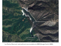
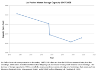
The Los Padres Reservoir had an initial storage capacity of 3,130 acre-feet. By 2008, the Los Padres Dam had lost almost half of its capacity to heavy sediment accumulation [1].
The Los Padres reservoir serves as the primary source of water storage for the Monterey Peninsula. A large increase in sediment accumulation would decrease the storage capacity of the reservoir, which could reduce Monterey Peninsula's water storage capacity.
Potential solutions for addressing the diminishing storage capacity of the reservoir include dredging, dam removal, changing the dam elevation, and construction of a new dam and reservoir system.
Location
The Los Padres Reservoir is on the Carmel River in Central California. The reservoir is located 30 km southeast of the city of Carmel, and is bounded by the Santa Lucia Range to the south, Jacks Peak to the north and Sierra de Salinas to the east.
Capacity Changes
The Los Padres Reservoir was constructed with an initial capacity of 3,130 acre feet. The steep, unstable granitic slopes within the watershed are highly susceptible to erosion, leading to natural sediment accumulation within the reservoir. [2]
In August 1977, the Marble-Cone fire burned approximately 178,000 acres in the Santa Lucia Mountains, affecting virtually all of the Carmel watershed above Los Padres Reservoir. The US Forest Service estimated that less than 10% vegetative cover remained on over half the watershed. Unusually heavy rainfall in the months following the fire led to increased erosion within the watershed. In the three years following the fire the sediment deposition in the reservoir was about equal to the total deposition from the previous thirty years. By October 1980, the reservoir was left with a capacity just under 2000 acre feet. [3]
In 1984, sediment was removed from the reservoir, which increased the capacity to 2,179 acre feet. [1]
The 2008 Basin Complex fire burned 64% [4] of the watershed above the Los Padres reservoir. Unlike the Marble-Cone fire, there was not an increase in the sediment deposition in the reservoir. This is likely due to the low rainfall years that followed the fire.[5]
In 2008 a stage-volume study completed by the CSUMB Watershed Institute measured the reservoir capacity at 1,785 acre feet. [1]
Resources at Stake
The water supply for the Monterey Peninsula is at stake. An increase in sediment in the Los Padres reservoir decreases the total water storage capacity.
Steelhead trout habitat is at stake. Increased sediment accumulation may degrade water quality and pose a threat to essential steelhead trout habitat [6]. Each year a certain amount of water is released from the dam during the low flow season [7]. If there is a decrease in the water storage within the reservoir, then there may be less water released into the Carmel River. This decrease in water could threaten critical habitat.
Proposed Solutions
Over the years, several potential solutions have been discussed to address the diminishing capacity of the reservoir. In 1994-1995, CalAm proposed and submitted an EIR for the New Los Padres Dam Project, a 24,000 acre foot dam and reservoir to be located downstream from the existing Los Padres Dam. The EIR was certified by the Monterey Peninsula Water Management District (MPWMD), but a bond measure to fund the project was not passed by the electorate, and the project stalled. It was re-proposed in 1998 as the Carmel River Dam and Reservoir Project. [8]
A 2008 MPWMD memo discussed the possibility of improving storage capacity by increasing the elevation of the dam. [9] Dredging and dam removal have also been proposed. Discussion of the possible actions is ongoing, with the National Marine Fisheries Service and NOAA favoring dam removal while the state Department of Fish and Game and MPWMD support dredging the reservoir. [10] [11]
In 2013 the debate about the best solution for the Los Padres Dam continued. CalAm was considering removing the dam, which has been encouraged by NOAA fisheries who argue in the draft steelhead recovery plan that the dam either needs to be removed or fish passage needs to be enhanced. However, this is in contrast with California Department of Fish and Wildlife, who are concerned that the removal of the dam would decrease the available water flow for fish habitat [12] MPWMD and CalAm are conducting studies to analyze the potential expansion of the reservoir by dredging, as well as looking at the impacts of dam removal [13] [14]
In 2014 MPWMD began to analyze ways to utilize the Los Padres reservoir as a supply of drinking water in response to the drought. [15] The water district board has begun to discuss the potential of the reservoir, but the processes and finances still need to be determined. The potential expansion of the reservoir is in conjunction with a portfolio of other water projects such as desalination, groundwater replenishment, and underground water storage to secure water supply for the Monterey Peninsula Residents. [16]
Stakeholders
Stakeholders who have an interest in the status of the Los Padres Reservoir include:
- California American Water Company (CalAm)
- Monterey Peninsula Water Management District (MPWMD)
- Monterey Peninsula Residents
- Steelhead trout interests (e.g. NOAA-NMFS, CDFW, Carmel River Steelhead Association (CRSA), Trout Unlimited)
Laws, Policies, & Regulations
Policies and regulations that apply to the situation with the reservoir include:
In 1995 the State Water Resources Control Board (SWRCB) adopted WR 95-10, which found CalAm was diverting more water from the Carmel River than they were allocated. WR 95-10 ordered them to decrease their water diversion to their legally allocated amount. [17] In 2009 the SWRCB issued a cease and desist order (CDO) (WR 2009-0060) against CalAm because they had continued to draw 10,730 acre feet annually, which is 7,150 acre feet more than they are allocated, for the 13 years after WR 95-10 was adopted. [18] As a result of the CDO CalAm will have to decrease the amount of water diverted from the Carmel to 3,376 acre-feet by 2016. This is a 70% reduction in the amount of water diverted from 2009 to 2016. [19]
Steelhead were first listed at threatened under the Endangered Species Act in 1997 in the Central Coast of California. [20] As a result of this listing the Los Padres Dam is under stricter regulations to ensure that the dam is not a barrier to steelhead migration. This issue can either be addressed though dam removal or through enhanced fish passage, such as a fish ladder.
Under the division of safety of dams through the Department of Water Resources, dams must regularly be assessed for compliance with dam safety standards to prevent catastrophic failure. [21] While there is currently not an issue with the Los Padres Dam in terms of dam safety, the dam would have to undergo a thorough review in the event of any changes to the dam or the reservoir. Furthermore, the San Clemente Dam, downstream of the Los Padres Dam, was not in compliance with dam safety standards, particularly the seismic safety standards, which was one of the major reasons for its removal. [22] Changes or alterations to the Los Padres Dam would also have to be in compliance with these standards.
Science and Technology
Projects and technologies that can be applied to capacity issues at the reservoir include:
- The USGS and USFS both have projects assessing burn events:
- The USGS Post-Wildfire landslide project analyzes and predicts the hazards after wildfires. This includes potential landslides, debris flows, water degradation, flood risk and ecosystem damage. [23].
- Through the Department of the Interior, the US Forest service and USGS work cooperatively to form Burned Area Emergency Response(BAER) teams that rapidly assess burn areas using remote sensing and satellite imagery [24].
- Geologists, hydrologists and biologists continue to study erosion, siltation, fish habitat and hydrology in relation to water storage, water supplies and river ecosystems.
- Hydrologic Computer Modeling can be used to analyze the watershed and the role of the Los Padres Dam in the hydrology of the Carmel River. Hydrologic modeling could also be effective in assessing the impacts of overland flow and sediment transport after a wildfire [25]
- Aerial photography and satellite imagery ( AVHRR ) can be used to analyze the changes in the size of the reservoir and to monitor burn areas and landslides.
- LIDAR data can be merged with multibeam bathymetry data to create high resolution digital elevation maps to quantify the change in the reservoir capacity [1].
Future research
There are many potential research opportunities available related to the reservoir. Some ideas include:
- Quantifying the current sediment load in the Los Padres Reservoir and assessing the impacts of increased sediment accumulation. This information would aid MPWMD in future water management decisions.
- Potential future CWSP MS thesis topic:
- Analyzing pre/post fire LIDAR and multibeam bathymetry data of Los Padres Reservoir to quantify sediment change related to wildfires.
References
- ↑ 1.0 1.1 1.2 1.3 2008 Stage-Volume Report for Los Padres Reservoir
- ↑ Assessment of Carmel River Watershed
- ↑ B. Hecht 1981
- ↑ Basin-Indians Fire SEAT Report
- ↑ Geomorphic Change in the Upper Carmel River
- ↑ Newcombe CP, MacDonald DD. 1991. Effects of Suspended Sediments on Aquatic Ecosystems. North American Journal of Fisheries Management 11 (1):72-82
- ↑ 2009 MPWMD Letter
- ↑ MPWD Draft EIR Executive Summary
- ↑ 2008 MPWMD Memo
- ↑ November 2012 Carmel Pine Cone Article
- ↑ A River Tamed- Monterey County Weekly May 2012
- ↑ Water District May try to Save Los Padres Dam- Monterey Herald 2013
- ↑ MPMWD Board Meeting Aug. 14 2013
- ↑ MPMWD Board Meeting Oct. 21 2013
- ↑ Officials eyeing Los Padres Dam as water source amid drought - KSBW News
- ↑ MPMWD Water Supply Projects in Progress
- ↑ SWRCB WR 95-10
- ↑ SWRCB WR 2009-0060
- ↑ MPWMD FAQ on CDO Feb. 2011
- ↑ NOAA North Central Coast Recovery
- ↑ DWR dam regulations and statutes
- ↑ CalAm San Clemente Dam Removal Project
- ↑ USGS Post-Wildfire Landslide Hazards
- ↑ Burned Area Rehabilitation
- ↑ Beeson PC Martens SN Breshears DD. 2001. Wildfire: Mapping Vulnerability to Landscape Disturbance. Hydrological Processes 15 (15):2917 - 2930
Links
- Other Watershed Issues
- San Clemente Dam
- ENVS 560/L Watershed Systems
- CalAm Use of Carmel River Groundwater Basin
- Desalination in the Central Coast
Disclaimer
This page may contain student work completed as part of assigned coursework. It may not be accurate. It does not necessary reflect the opinion or policy of CSUMB, its staff, or students.

